Forecast for the Provo Area Mountains

Nikki Champion
Issued by Nikki Champion for
Wednesday, January 17, 2024
While the overall avalanche danger is CONSIDERABLE on most slopes early this morning, the combination of heavy snowfall and strong winds will cause the avalanche danger to rise to HIGH as the day progresses. Keep a close eye on changing weather conditions, as the avalanche danger will increase with the intensification of the storm.

Today, there are three avalanche problems to watch for: (1) triggering a slab avalanche 4-6' deep in the weak faceted snow, (2) both soft and hard slabs of wind drifted snow that would likely steep down into the weak snow below, and (3) sluffing and soft slab avalanches within the new snow.
What to do? Stick to slopes less than a 30-degree today. Stay away from, and avoid slopes connected to, anything steeper than about 30 degrees.
Low
Moderate
Considerable
High
Extreme
Learn how to read the forecast here
Special Announcements
Weekend storms delivered unprecedented avy conditions and Extreme danger for the mountains of Northern Utah. Wondering how we got there and where we're going? Well then... you came to the right place!
Please join Craig Gordon 6:00-7:00 tonight for a State of the Snowpack presentation at the A. Ray Olpin Student Union- Saltair Room 200 Central Campus Dr, Salt Lake City, UT 84112.
But wait... there's more! Following Craig's presentation is an amazing panel discussion focusing on Mountain Resilience: Navigating Grief, Long-Term Injury, and Identity Crisis in the Backcountry, delivered by a truly remarkable trio of women... Jess Shade, Jessie Brunelle, and River Barry. More info HERE.
Weather and Snow
This morning, the skies are overcast, and snow has resumed in the mountains. Temperatures range in the mid 20s. Winds are coming from the southwest at 20-30 mph, with gusts up to 40 mph. Along the highest elevations, gusts are up to 50 mph. The days of elevated winds have affected the mountains at all elevations.
Today, a trough moving from Oregon to northern Utah will bring significant snowfall, with peak rates of 2 inches per hour between 8 AM and 11 AM. Snow rates will decrease in the afternoon, followed by another wave bringing increased snow rates, from midnight to 4 AM on Thursday. Expected snowfall totals by 5 PM are between 3.5-7.5 inches, with an additional 2-6 inches overnight. Overall, the snow total could range from 10-18 inches with 1.0-1.60 inches of water. Northwest winds will remain elevated, averaging 20-25 mph at mid-elevations and 30-40 mph at the uppermost elevation, with gusts up to 50 mph. Temperatures will climb into the upper 20s and low 30s F.

With this last storm, we are back on track - most areas are at or above "median" snow-water for the year.
Recent Avalanches
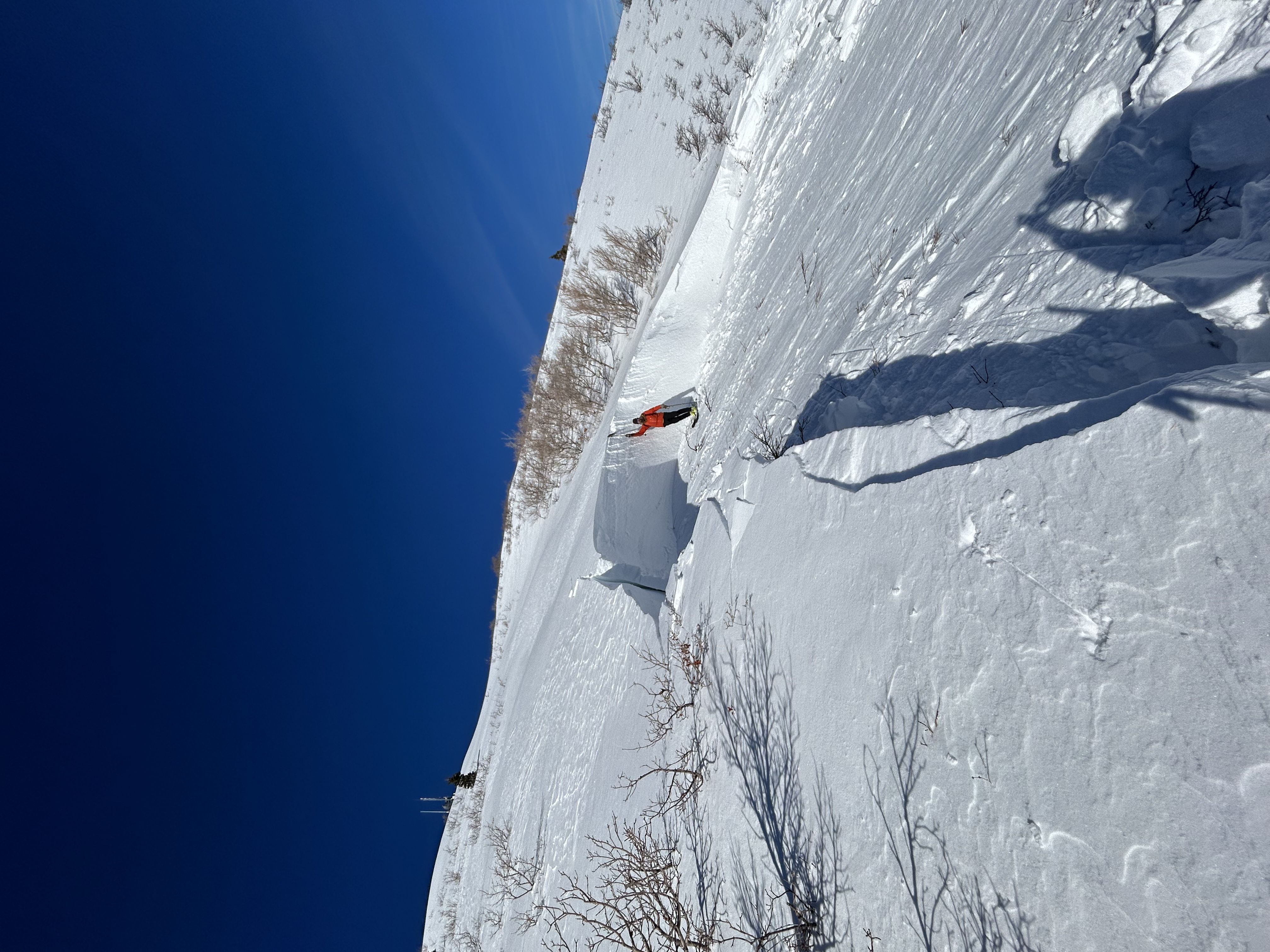
Yesterday, there were multiple rider triggered avalanches in the backcountry. One of the most noteable being a hardslab avalanche that was triggered above the MF Crust on damp facets by three deer in Trailer Court East at an elevation of 7700 feet on the northeast slopes. The average depth of the avalanche is 3 feet, with one section measuring around 8 feet. Notably, the slab was pulled all the way back onto the flat ridge line. This incident occurred either yesterday morning, or the prior night.
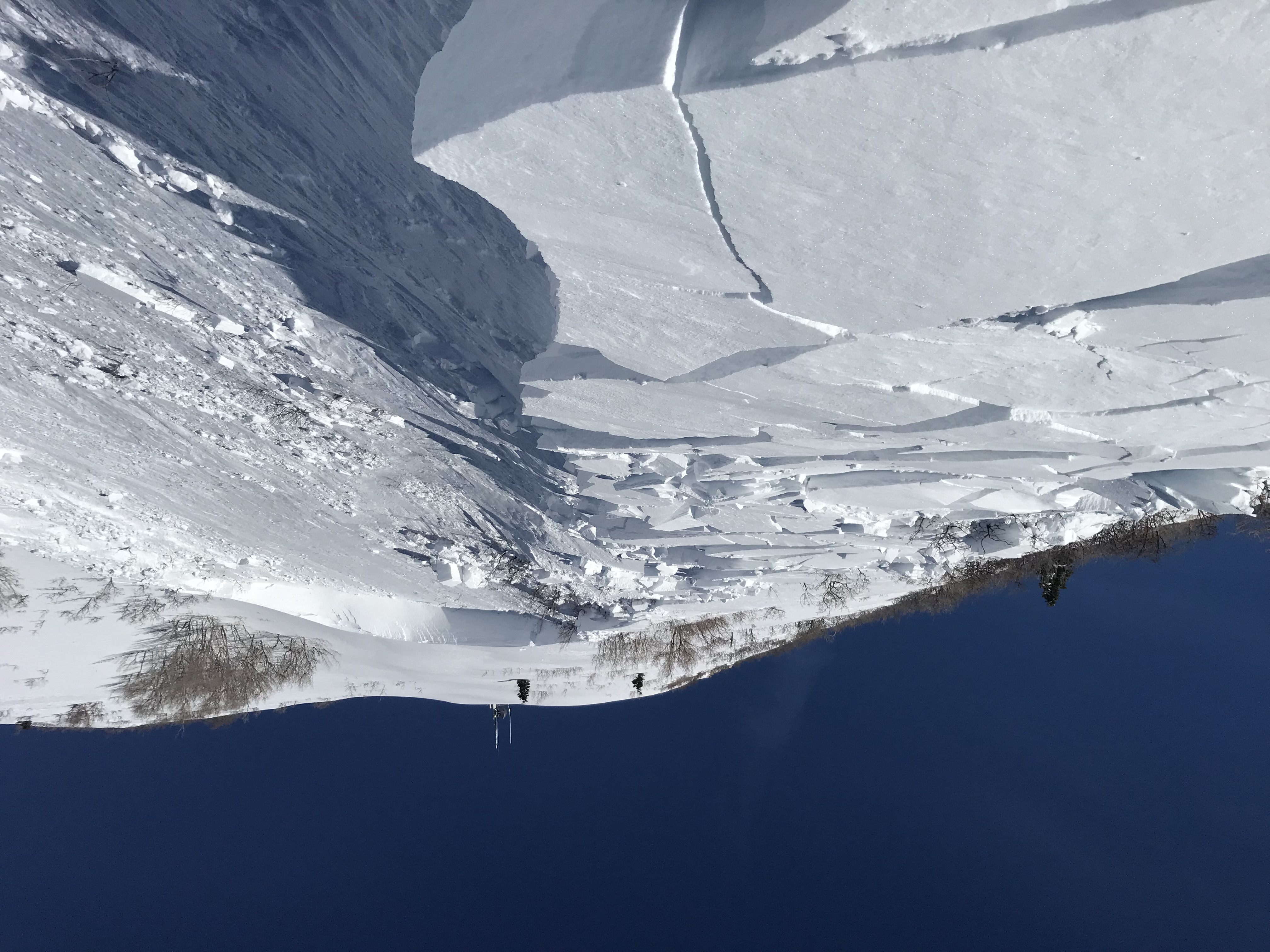
(Photos: Woody)
Overall the area is like a war zone, the last two days of clearing provided an excellent view of the Extreme avalanche conditions. There were numerous avalanches, many breaking at least 4 feet deep at the December persistent weak layer of facets, with some stepping down to the ground. Reports include avalanches on Gobblers Knob in Butler Basin stretching 2500 feet wide and a similar-sized avalanche in the Meadow Chutes of Silver Fork. Ski area control teams triggered numerous avalanches, some reported to be 6-12 feet deep, mostly on north to southeast-facing slopes at mid and upper elevations. However, a couple of natural avalanches occurred near 1000 Springs, leaving a massive debris pile with timber on the upper groomed Mill Creek Canyon path, a couple of miles above the closed gate. According to the old-timers, none of them remembers an avalanche of that magnitude into Mill Creek Canyon.
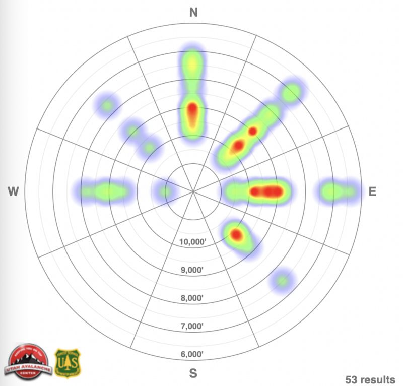
Avalanche Heat map for the Salt Lake, Provo and Ogden area mountains since Friday 1/12.
Since Friday, we've received information about two complete avalanche burials (Main Porter, American Fork) and indications of a third, all successfully rescued by partners or bystanders. Additionally, there have been reports of several skiers and riders being caught and carried, with positive outcomes. Unfortunately, a skier lost their life in a Wyoming avalanche on Sunday (Details).
Be sure to check all the avalanche activity HERE.
Ad
Avalanche Problem #1
Persistent Weak Layer
Type
Location
Likelihood
Size
Description
These avalanche conditions remain highly dangerous, despite the peak of instability occurring over the weekend. While avalanches may not be as hair-trigger, cracking and collapsing are still present. Today another frontal system is moving in, bringing additional snow and wind. This increased load will casue the sensitivity of this weak layer to increase yet again.

Despite the good skiing conditions, it's crucial to recognize that all aspects are suspect, and large, destructive avalanches have occurred even at lower elevations. Soft and hard slab avalanches may be more stubborn, but they can still be triggered at a distance, making survival unlikely if caught in one of these monsters.
We must allow more time for this layer. Avoid traveling in any avalanche terrain, as these avalanches could be triggered remotely, from a distance, or, worse, from below!
Avalanche Problem #2
Wind Drifted Snow
Type
Location
Likelihood
Size
Description
Winds remain elevated, with overnight gusts near 70 mph. With high winds and so much soft snow available for transport, you are likely to find both soft and hard slabs of wind-drifted snow on all upper-elevation slopes, and mid-elevation terrain features that allow for drifting snow to accumulate. These slabs will be most pronounced on lee-ward facing slopes, but high winds can load any aspect because winds swirl and change direction as they pass through the mountains, this is known as cross-loading.

Though alluring, these smooth-looking, rounded pillows of snow are sitting on top of very weak, pre-existing surface snow. The best riding conditions will be in sheltered, lower-angle terrain out of the wind.
Avalanche Problem #3
New Snow
Type
Location
Likelihood
Size
Description
The issue is straightforward today: as snowfall intensity increases, so does the avalanche danger. The approaching front is expected to bring periods of high snowfall rates and overall high snowfall totals. Anticipate shallow new snow avalanches in the backcountry, especially in the upper elevations, with fast-running sluffs likely.
The type of avalanche will depend on how quickly the new snow bonds compared to the rate of snowfall. Watch for signs of instability like cracking and sluffing, as even a small slide can pose serious risks in steep terrain or near cliffs. The sensitivity of the new snow is closely tied to the rate of snowfall, with higher rates (greater than 2 inches per hour) making avalanches easier to trigger. Be alert to changing weather and increased snowfall rates, if snowfall totals surpass forecasts the danger could rise sooner than expected!
General Announcements
This information does not apply to developed ski areas or highways where avalanche control is normally done. This forecast is from the U.S.D.A. Forest Service, which is solely responsible for its content. This forecast describes general avalanche conditions and local variations always occur.