Forecast for the Provo Area Mountains

Mark Staples
Issued by Mark Staples for
Wednesday, January 16, 2019
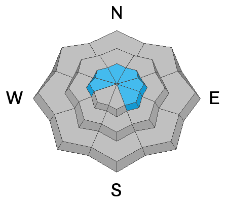
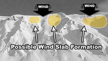
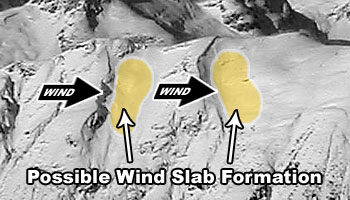
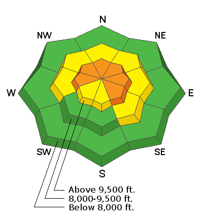
Today with new snow and S and SW winds, the avalanche danger is CONSIDERABLE at upper elevations. In these locations, wind drifts alone may produce an avalanche, however, the heavy new snow combined with the additional weight of wind drifted snow, may cause avalanches to break on buried persistent weak layers.
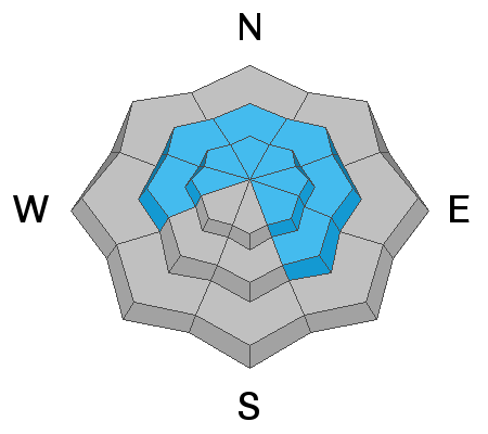
The danger is MODERATE mid elevations where wind drifts should be less common. Persistent weak layers exists at these mid elevations, but lacking the addition load of wind blown snow, they may not be as sensitive. At low elevations the danger is LOW where avalanche conditions are generally safe.
Low
Moderate
Considerable
High
Extreme
Learn how to read the forecast here
Special Announcements
Listen to the first full length episode of the UAC Podcast. Breaking the Stigma with Traumatic Stress - Another Conversation with Dave Richards. Download it on iTunes, Stitcher or from the UAC Blog.
Weather and Snow
It's snowing this morning with about 5-8 inches in the Provo area mountains. This snow is heavy and dense with 0.6 - 1 inches of water in it.
Temperatures are in the mid to upper 20's F.
Winds are blowing 10-15 mph with gusts of 25-35 mph from the S and SW.
Today, temperatures at upper elevations should warm into the upper 20's F and at lower elevations into the mid 30's F. The strongest winds will be this morning and decrease some this afternoon. Snow should continue this morning but taper off by midday. Skies will stay cloudy and more snow returns tomorrow morning.
Recent Avalanches
There have been no reported avalanches during the last two days. There were some slabs of wind drifted snow triggered over the weekend.
On Sunday there was a skier triggered slide in American Fork Canyon. We don't have an avalanche report to view on this one, but it broke on a thin layer of weak facets, about 2 feet deep, on an east facing slope at 9600 ft. It was about 250 feet wide.
Ad
Avalanche Problem #1
Wind Drifted Snow
Type
Location
Likelihood
Size
Description
With new snow this morning and S and SW winds, look for fresh slabs of wind-drifted snow. These can either be formed by wind-loading from the top of ridges OR cross loading along the edges of gullies and sub-ridges. The simplest way to deal with this problem is to look for it and then avoid it. Ski cutting may be an option but it is a high risk maneuver that often surprises professional ski patrollers who have a lot of practice doing it. There are older wind slabs covered by new snow. These have most likely stabilized but a few could remain sensitive. Places with new wind slabs are likely places with older wind slabs.
Image below of top loading.
Image below of cross loading
Avalanche Problem #2
Persistent Weak Layer
Type
Location
Likelihood
Size
Description
With snow containing up to an inch of water so far this morning, this additional weight may begin to awaken persistent weak layers of faceted snow buried about 2-4 feet deep. To be clear. when I say awaken, I mean that this layer could start producing avalanches today. With the additional weight of wind drifted snow, avalanches on this layer become even more likely.
Yesterday my partner and I skied in Little Cottonwood Canyon. We identified and avoided areas of wind drifted snow. A harder problem to avoid is a persistent weak layer of facets. There are some near the ground, but these have not produced an avalanche in a long time. Periods of dry, cold weather in mid December and early January formed a layer of sugary facets that are now buried 2-4 feet deep.
The only way we could find this avalanche problem was by putting our shovels in the snow. We dug quick snowpits and performed extended column tests (how to video). This test can help find weak layers when the colum breaks under your shovel. If it breaks across the column (propagates), that is a bad sign.
Additional Information
The Wasatch range has a complex snow surface for the incoming storms to land on - near surface facets, surface hoar and a variety of weak crusts and hard old wind slabs with facets above and below. If you’re out and about today, see how the new snow has bonded to yesterdays snow surface.
If you’re heading further afield, here’s a great observation from the Oquirrhs.
General Announcements
This information does not apply to developed ski areas or highways where avalanche control is normally done. This forecast is from the U.S.D.A. Forest Service, which is solely responsible for its content. This forecast describes general avalanche conditions and local variations always occur.