Forecast for the Provo Area Mountains

Trent Meisenheimer
Issued by Trent Meisenheimer for
Sunday, January 14, 2024
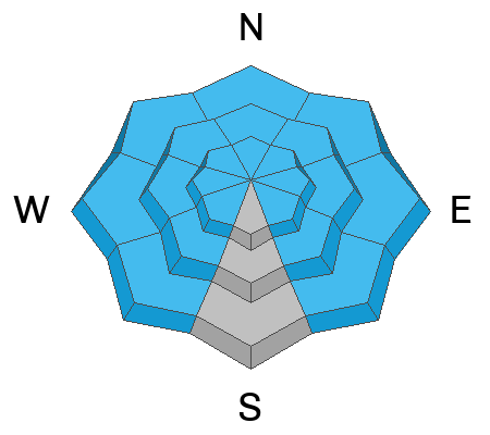
THE AVALANCHE DANGER IS EXTREME, EXTRAORDINARILY DANGEROUS AVALANCHE CONDITIONS. NATURAL AND HUMAN-TRIGGERED AVALANCHES ARE CERTAIN. AVOID ALL AVALANCHE TERRAIN.
DEADLY AND DANGEROUS AVALANCHE CONDITIONS EXIST ON ALL ASPECTS AND ELEVATIONS.
Low
Moderate
Considerable
High
Extreme
Learn how to read the forecast here
Avalanche Warning
The avalanche danger for the warning area is HIGH and EXTREME for the mountains of northern and central Utah and southeast Idaho, which includes the Wasatch Range...the Bear River Range...Uinta Mountains...Manti-Skyline plateau...and the Mountains of Southwestern Utah.
Strong winds and heavy snowfall have created dangerous avalanche conditions. Avalanches failing on a widespread persistent weak layer buried under the new snow are very likely. Avoid all avalanche terrain.
This avalanche warning is in effect from Sunday, January 14, 2024 - 6:00am to Monday, January 15, 2024 - 6:00am
Weather and Snow
A wave of moisture has slammed into the Wasatch Front, and the overnight snow and water totals are impressive. In the past 24 hours, we've picked up 12-24 inches of new snow with 1.95-3.09 inches of water. Some overnight hourly readings had more than 3" per hour snowfall rates. Impressive, to say the least. Since January 9, the mountains have picked up roughly 50" of new snow containing close to 4 inches of water in the Provo area.
This morning, it continues to snow. Mountain temperatures are in the low-to-mid 20s °F. Winds remain from the west and northwest, averaging 20-30 mph with gusts into the 40s across the upper elevations. At 11,000’ it's a different story where the wind blows 50-60 mph, gusting 85.
Today, we will continue to see heavy snowfall and strong winds. Around mid-morning, the temperature and snow densities will drop as the flow veers to the northwest. Winds will remain active from the northwest, blowing at 15-30 mph and gusting into the 40s. By the end of the day, snow totals could be 12-20 inches of new snow. We could see a total of 30-40 inches of new snow by Monday evening. Unreal.
Recent Avalanches
Currently as I type, we are going through a widespread natural avalanche cycle as the mountains are overloaded by strong winds and heavy snowfall. Avalanches are happening now!
Yesterday, the headline was a close call in American Fork, where three riders were caught and carried. Two were partially buried, with one person being fully buried several feet deep. Luckily, another group was in the area as they rolled up and found and dug out the buried rider. The rider came out of the snow blue but he was ok.
Backcountry observations of natural avalanches, remotely triggered avalanches, and large booming collapses continue to pour into the UAC. Be sure to check all the avalanche activity HERE.
Ad
Avalanche Problem #1
Persistent Weak Layer
Type
Location
Likelihood
Size
Description
STRONG WINDS AND HEAVY SNOWFALL HAVE OVERLOADED ALL STEEP AVALANCHE-PRONE TERRAIN. To make matters worse, we have a widespread buried persistent weak layer that makes these avalanches even more dangerous. Tree snapping, bone-crushing, deadly avalanches 3-6 feet deep and hundreds of feet wide are CERTAIN. Natural avalanches will also be roaring down from above and will travel long distances, slamming into the valleys below.
This is one of the more dangerous times I can remember in my career. There is no outsmarting this problem. Please take these avalanche conditions seriously and AVOID ALL AVALANCHE TERRAIN. This means being under any avalanche terrain as well. Avalanches can run long distances way out into the flats.
Avalanche Problem #2
Wind Drifted Snow
Type
Location
Likelihood
Size
Description
Strong winds from the west and northwest are drifting the new snow into dense, thick hard or soft slabs of wind-blown snow. These slabs are guaranteed to break along ridgelines and other terrain features where the wind has loaded the slope, making the avalanche that much bigger and therefore more dangerous.
Any avalanche triggered will likely fail on a persistent weak layer of faceted snow and could be 3-6 feet deep and hundreds if not thousands of feet wide. AVOID ALL AVALANCHE TERRAIN.
Avalanche Problem #3
New Snow
Type
Location
Likelihood
Size
Description
Overnight snowfall rates were well over 2-3" per hour (0.10-0.40" water per hour) and it's still snowing hard. With more snow throughout the day, the mountain will continue to be overwhelmed, and like all things in nature, it will reach equilibrium by avalanching. AVOID ALL AVALANCHE TERRAIN.
General Announcements
This information does not apply to developed ski areas or highways where avalanche control is normally done. This forecast is from the U.S.D.A. Forest Service, which is solely responsible for its content. This forecast describes general avalanche conditions and local variations always occur.