Donate to the 2024 Spring Campaign to help rebuild the UAC website.

Forecast for the Ogden Area Mountains

Greg Gagne
Issued by Greg Gagne for
Friday, April 21, 2023
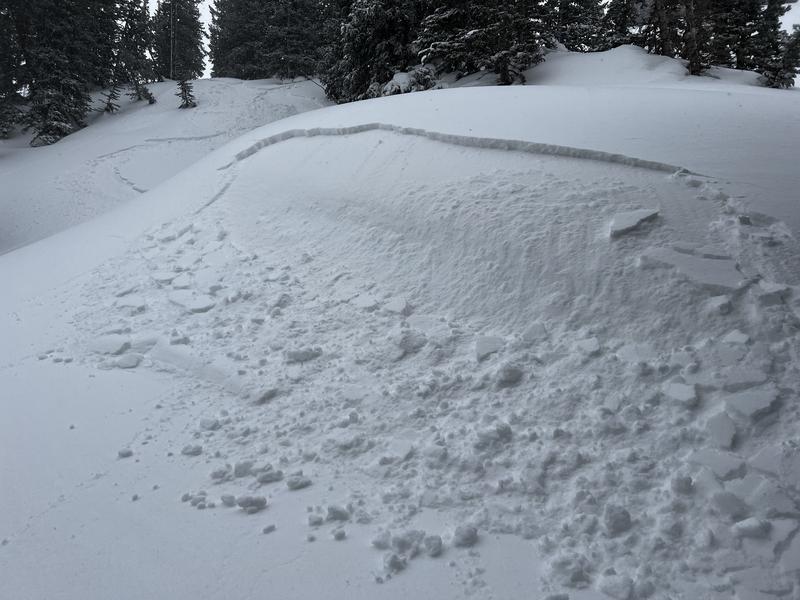
The avalanche danger is MODERATE on upper elevation aspects facing northwest through northeast and southeast where there are fresh soft slabs of wind-drifted snow. The danger is LOW at low and mid elevations.

I am uncertain about snowfall this afternoon and the avalanche danger could quickly rise during any period of heavy snowfall. Be aware that conditions may change rapidly.
Low
Moderate
Considerable
High
Extreme
Learn how to read the forecast here
Special Announcements
The last daily forecast will be Sunday, April 23. We will provide intermittent updates with any storm until Sunday, May 7th and will continue posting backcountry observations until then.
The UAC is sad to report that a resident was killed by a roof avalanche on Monday, April 17th, in the Town of Brighton. A report is available HERE. Many communities still have a lot of snow on roofs that could produce similar avalanches.
Weather and Snow
Snow totals from Thursday are 1-2".
This Morning: Temperatures are in the low20's F and the westerly winds are gusting into the 20's mph along exposed ridgelines at the mid and upper elevations.
Today: Snow will develop around midday and possibly become heavy at times later this afternoon, with 2-4" of new snow expected by early evening. Temperatures will rise into the 30's F and the west/northwest winds will gust into the 20's mph along exposed mid and upper elevation ridgelines.
Overnight/Saturday: Strong winds with periods of heavy snowfall possible. Snowfall totals are proving challenging to forecast, but we may see 4-8" of new snow by Saturday morning.
Extended: Sunny Sunday with a chance of snow Monday and Tuesday.
Recent Avalanches
We received no reports from the Ogden area mountains on Thursday. To our south in the Salt Lake mountains, shallow, sensitive soft slabs up to 6" thick and 10-20' wide were reported from the backcountry on Thursday.
Ad
Avalanche Problem #1
Wind Drifted Snow
Type
Location
Likelihood
Size
Description
Shallow, soft slabs of wind-drifted snow will be found at the upper elevations as well as some exposed mid-elevation ridgelines. These wind drifts will mostly be found on aspects facing northwest through east and southeast, but be aware that fresh drifts can be found on any aspect due to cross-loading. Also watch for sensitive cornices along exposed ridgelines.
With a smooth bed surface, any avalanches may run fast and far.
General Announcements
This information does not apply to developed ski areas or highways where avalanche control is normally done. This forecast is from the U.S.D.A. Forest Service, which is solely responsible for its content. This forecast describes general avalanche conditions and local variations always occur.