Forecast for the Ogden Area Mountains

Nikki Champion
Issued by Nikki Champion for
Wednesday, April 19, 2023
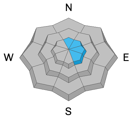
The avalanche danger is MODERATE across upper elevation terrain facing north through east through southeast for shallow slabs of wind-drifted snow. Be on the lookout for pockets of reactive wind-drifted snow, especially in steep, consequential terrain where even a small avalanche can have a detrimental outcome.
Out of the wind zone, the avalanche danger is LOW.
Low
Moderate
Considerable
High
Extreme
Learn how to read the forecast here
Special Announcements
The last daily forecast will be Sunday, April 23. We will provide intermittent updates with any storm until Sunday, May 7th and will continue posting backcountry observations until then.
Weather and Snow
Under mostly cloudy skies, winter has returned to the Ogden area with trailhead temperatures in the mid-teens °F and the highest weather station temperatures hovering below 10 ˚F. Winds are lightly blowing from the west with gusts up to 30 MPH . The mountains picked up a trace amount to 2-4" of new snow in the last storm.

Today will remain mostly cloudy. Temperatures will climb into the mid-20s F. Wind speeds will remain light throughout the day blowing from the west gusting to 35 MPH at the highest ridgelines. There is a minimal chance for trace precipitation throughout the day.
The unsettled weather remains in place tonight, as periods of thick cloud cover and precipitation will move through the area with the best chance of accumulation this evening.
Recent Avalanches
We had no reports of avalanches from the backcountry yesterday. Find all avalanche and snowpack observations HERE.
Ad
Avalanche Problem #1
Wind Drifted Snow
Type
Location
Likelihood
Size
Description
The moderate to strong westerly winds from yesterday will have transported the new snow onto leeward aspects to form sensitive drifts that will be reactive to riders today. Rounded pillows of new snow that crack or collapse on approach are sure signs that the wind-drifts are sensitive and should be approached with caution.
Use small test slopes to see how the new snow behaves before committing to a more aggressive terrain objective.
General Announcements
This information does not apply to developed ski areas or highways where avalanche control is normally done. This forecast is from the U.S.D.A. Forest Service, which is solely responsible for its content. This forecast describes general avalanche conditions and local variations always occur.