Forecast for the Ogden Area Mountains

Drew Hardesty
Issued by Drew Hardesty on
Thursday morning, March 27, 2025
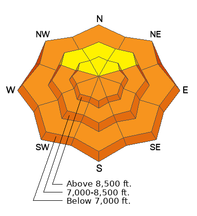
The avalanche danger will quickly rise again to CONSIDERABLE on all steep easterly to southerly to westerly facing aspects for wet loose and some wet slab avalanches. Even some mid and upper elevation polar aspects will have elevated danger. Natural and human triggered avalanches are likely. CORNICES are a significant hazard and may trigger avalanches below.
Travel Advice: It's a day to avoid steep, avalanche prone terrain, particularly by mid/late morning.
Low
Moderate
Considerable
High
Extreme
Learn how to read the forecast here
Special Announcements
Our Spring Campaign is in full swing, and there are two great ways to support forecasting, awareness, and education across Utah: Donate to our Spring Campaign, or Bid on items in our Spring Auction. Every dollar donated helps keep the backcountry community on top.
Weather and Snow
Skies are clear. Winds are blowing 15-20mph from the southwest. It's gusting to 40mph along the highest ridgelines.
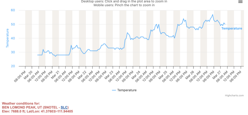
Overnight "lows" are in the mid-40s to low 50s. Wow. See the Ben Lomond weather station graph below - you'll see that the 'last, best" refreeze was the morning of March 23rd.
For today, we'll see increasing high and mid-level clouds by early afternoon. The southwesterly winds will only ramp up as the day wears on and we may see gusts to 60 or 70 by late evening. A little ripple in the flow brings a touch of precipitation overnight with an early rain/snow line up to 9500'. Shouldn't be more than a trace or two. Temps cool slightly for Friday with a quick little storm for Saturday afternoon that might bring 4-8" of winter. Next week looks somewhat active.
Recent Avalanches
More natural wet loose avalanches were reported from the backcountry with debris piles large enough to bury a person.
You can check out all recent observations and avalanches HERE.
Ad
Avalanche Problem #1
Wet Snow
Type
Location
Likelihood
Size
Description
Wet loose and some wet slab avalanches can be expected today on many solar aspects. Due to the extreme heat, some mid and upper elevation polar aspects may be susceptible to wet loose avalanches. Timing is key. When you see rollerballs and pinwheels and the snow becomes unsupportable, head for low angle terrain or aspects less affected by the sun. More info below:
A couple things of note:
  1. Wet loose avalanches on nearly all aspects and elevations. Mountain temperatures will be warmer than yesterday, with warmer temps than yesterday. Some mid/upper elevation north facing slopes may be susceptible to wet loose avalanches.
  2. Wet slab avalanches. Some areas have not had a proper deep freeze for a couple of nights and free water pooling at various structural interfaces tends to promote wet slab releases. Wet slabs are generally much more dangerous and destructive than wet loose.
  3. Cornices are becoming weak and tender and are big enough to trigger large avalanches below, particularly on slopes that have avalanched previously this season. These are generally mid and upper elevation northwest to east facing slopes.
  4. Roofs are shedding their winter loads. Please keep an eye on people, kids, animals underneath the roof lines.
General Announcements
This information does not apply to developed ski areas or highways where avalanche control is normally done. This forecast is from the U.S.D.A. Forest Service, which is solely responsible for its content. This forecast describes general avalanche conditions and local variations always occur.