Forecast for the Ogden Area Mountains

Dave Kelly
Issued by Dave Kelly for
Tuesday, March 26, 2024
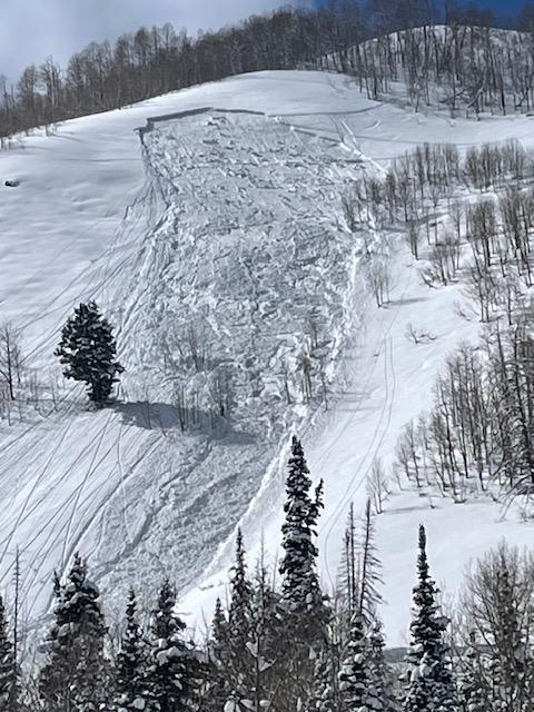
Today, there is a MODERATE avalanche danger on all aspects at the mid and upper elevations where human triggered soft slab avalanches are possible. The avalanche danger is LOW in lower elevation terrain.
Evaluate snow and terrain carefully today as the likelihood of triggering an avalanche will increase with additional precipitation, wind transport, and any hint of March sun that may create periods of increased instability.
Low
Moderate
Considerable
High
Extreme
Learn how to read the forecast here
Special Announcements
Support the UAC website backend platform to ensure the ongoing security of the website and the data stored on the site rebuild by donating to our spring campaign.
Weather and Snow
Currently under overcast skies trailhead temperatures are in the mid-20's °F while the highest peaks are in the mid-teens °F. Winds are blowing lightly from the west gusting to the teens MPH at the lower ridge-lines in the low 20's gusting to 30 MPH at the highest ridge-lines. There was another 2"-5" of new snow in the last 24 hours bringing storm totals to 8"-18"of snow and .80"-1.60" water.
Today, look for overcast skies with increasing chances of snow, wind, and lightning this afternoon. Temperatures are forecast to be 30-35°F with winds blowing from the north-northwest 10 gusting to 15 MPH at the 8,000' ridge-lines and from the west-northwest 25 gusting to 30 MPH at the 9,000' ridge-lines with chances for higher winds during increased snowfall. Look for 1"-2" of new snow with the off chance of 2"-4" and up to .30" water in select areas with increasing snowfall rates and winds this afternoon. The freezing level should stay around 5,000' which means that with cloudy skies and colder temperatures the snow surface will stay soft making for excellent travel today. With any hint of sun today the snow surface will heat up quickly and green-housing could occur on all aspects and elevations.
Read the updated forecast discussion from our partners at the National Weather Service HERE.
Recent Avalanches
Yesterday, we had no backcountry observations from the Ogden Area Mountains. Just south of Ogden in the Central Wasatch we had reports of soft slab avalanches up to 10"-18" deep. The avalanche that got my attention was in Big Cottonwood Canyon in the Silver Fork drainage. It was reported as 2.5' deep, 100' wide and ran 400' vertical feet (photo below). This avalanche is unique in that it appears to have started as a dry snow avalanche that took a hint of warming and then transitioned to a wet snow avalanche. It is much deeper than the other reported avalanches from the last two days and has more slab like characteristics. This is something you might see with any hint of warming on steep east facing terrain in the southern portion of the Ogden Forecast Region.

(Photo: Yannick)

Read all the observations HERE.
Ad
Avalanche Problem #1
New Snow
Type
Location
Likelihood
Size
Description
Over the last few days, the new snow has been reactive to backcountry travelers. The layer of weakness in most cases has been density changes within the newest snow. This weak layer was starting to settle out below 8,000' where it has become more difficult to trigger avalanches at lower elevations.
Today, it will be possible trigger a new snow avalanche failing on a density change. Any new snow that comes in this afternoon will be sensitive to backcountry travelers on steep slopes. IF the slope has had any wind or sun affect you may be able to trigger soft slab avalanches 10"-14" deep breaking above you.
Avalanche Problem #2
Normal Caution
Type
Location
Likelihood
Size
Description
Springtime in the mountains. What this means is that like the last weekend at your favorite ski resort most anything goes. You may see new snow avalanches, wind-drifted snow avalanches, wet snow avalanches, green-housing (filtered sun creating rapid warming of the snowpack at all elevations and aspects), glide avalanches, and thunder snow.
It's the time of year when it's easy to fall back on heuristic traps based on past experience, particularly familiarity. Keep your head about you when traveling in the mountains as even a small avalanche could have real consequences. Read more about heuristics and decision making from local avalanche researcher Ian McCammon HERE.
General Announcements
This information does not apply to developed ski areas or highways where avalanche control is normally done. This forecast is from the U.S.D.A. Forest Service, which is solely responsible for its content. This forecast describes general avalanche conditions and local variations always occur.