Forecast for the Ogden Area Mountains

Trent Meisenheimer
Issued by Trent Meisenheimer for
Thursday, February 8, 2024
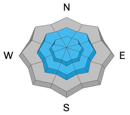
The avalanche danger is CONSIDERABLE across the mid and upper elevations for several avalanche problems. Pick your poison: Hard and soft slabs of wind-drifted snow. Soft slabs of new snow. Or you could trigger an avalanche that fails on a buried persistent weak layer. It's complicated and very dangerous.
In any case, the avalanche you trigger is likely a few hundred feet wide and could be 2 to 4 feet deep.
Low
Moderate
Considerable
High
Extreme
Learn how to read the forecast here
Weather and Snow
I can't say I am ever excited for it to stop snowing, but that was an intense few days here. Storm totals for the past 24 hrs are roughly 7-13 inches of new snow (0.6-1.35" water) for the Ogden Mountains.
This morning, under cloudy skies, it's snowing in some areas, the mountain temperatures range from 16-22 °F. Winds have finally calmed down and blow from the west at 5-15 mph across the upper elevations. As one storm exits, another is spinning over Sin City, which will bring light snow showers to the mountains today. Accumulations will be in the 1-3 inch range. Winds are forecast to be light and from the southwest with speeds of 5-15 mph. One more small storm Friday into Saturday before we clear on Sunday.
Recent Avalanches
Yesterday, the precipitation intensity spiked with rates well over 1" per hour snowfall, and I am sure we went through a widespread natural avalanche cycle at some point. One observer on Cutler Ridge spotted a natural avalanche on the Ben Lomond Headwall that ran at some point during the storm (photo below).
Ad
Avalanche Problem #1
Wind Drifted Snow
Type
Location
Likelihood
Size
Description
South wind has blown for 60 straight hours at speeds of 10-25 mph with gusts into the 20s and 30s. These are the perfect speeds for drifting snow onto lee slopes. These winds, combined with feet of dense, heavy snowfall, have created monster soft and hard slabs of wind-drifted snow in the starting zones. These will not be small avalanches. These avalanches can run long distances into the valleys below.
Avalanche Problem #2
New Snow
Type
Location
Likelihood
Size
Description
I would imagine the new snow is settling and bonding rapidly. However, it's just now stopped snowing, and I think it needs more time to adjust to the rapid loading event over the past few days of heavy snowfall. Soft slabs 1-3' deep will be found in steep terrain today.
Avalanche Problem #3
Persistent Weak Layer
Type
Location
Likelihood
Size
Description
If you think this layer is gone, I challenge you to get your shovel out and dig. I can find this layer everywhere: Skyline, Provo, Wasatch Back, SLC, Parkcity Ridgeline, Millcreek, Lambs, Sessions, Bountiful, Farmington, and Ogden.
This persistent weak layer of faceted snow is now roughly buried 2-6 feet deep with a very thick hard slab above it. Yes, the weak layer is gaining some strength. Yes, it's becoming harder to trigger this layer. However, if you do trigger an avalanche that breaks to this layer, it's likely to be a season-ender or worse. With so many close calls over the past few days, I am worried our luck will run out, and today through this weekend has accident written all over it. We could almost start writing the accident report now.
With the recent loading event, there is only one option in my mind, and that is to avoid avalanche terrain.
General Announcements
This information does not apply to developed ski areas or highways where avalanche control is normally done. This forecast is from the U.S.D.A. Forest Service, which is solely responsible for its content. This forecast describes general avalanche conditions and local variations always occur.