Forecast for the Ogden Area Mountains

Evelyn Lees
Issued by Evelyn Lees for
Thursday, February 28, 2019
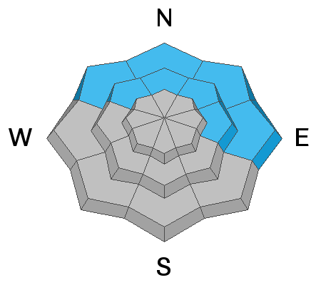
There is a MODERATE avalanche danger on upper elevation slopes where one of the scattered, hard wind drifts or a cornice can be triggered. There is also a MODERATE danger on mid and low elevation slopes facing northwest through easterly for triggering an isolated wind drift or triggering a wet loose sluff in steep terrain, especially if it rains where you are. In the LOW danger areas, isolated small, wet loose sluffs are possible.
Low
Moderate
Considerable
High
Extreme
Learn how to read the forecast here
Special Announcements
Enjoy spring skiing at Snowbasin Resort. The UAC has discount Snowbasin tickets available.
Are you new to the backcountry or looking to refresh your skills? The UAC has released a free 5-part avalanche skills eLearning series.
The latest podcast with Ian McCammon has been published. Check it out HERE.
Weather and Snow
This morning, under mostly cloudy skies, temperatures in the Ogden area mountains are in the mid twenties along the ridge lines and the low 30s at the mid elevations. The greatest cooling has occured at the lower elevations, where temperatures have dropped 10 to 15 degrees, and are now at or below freezing. It’s going to be another warm, humid day with cloudy skies and temperatures warming to near 40 at 8,500’ and near 30 along the highest ridge lines.
Yesterday, most locations picked up 1 to 2” of dense snow. Another trace to 2” of snow is possible this afternoon, with the rain/snow line between 6,500 and 7,000’.
The southwesterly winds are averaging 15 to 20 mph, with averages to 40 mph along the ridge lines, and should maintain those speeds today.
Yesterday, I found the snow at the low to mid elevations to be a challenging inconsistent mix of mashed potatoes and crusts. Overnight, the mountains could get 3 to 5” of snow as a weak cold front moves through. This will be followed by small disturbances adding 1 to 3” every 12 hours, which could add up to a nice refresh of dense snow at the mid and upper elevations.
Recent Avalanches
In the Ogden area mountains, resorts have been able to pry out isolated, stubborn hard wind drifts with explosives over the past few days, including one that was skier triggered.
There was an observation of new natural avalanches on the west facing slopes of the Ogden mountains, seen from town.
Ad
Avalanche Problem #1
Wind Drifted Snow
Type
Location
Likelihood
Size
Description
Avoiding the hard, "stubborn" slabs of wind drifted snow that are scattered at the upper elevations is the main avalanche issue today. These wind drifts are most widespread on north and northeasterly facing slopes, but can be found cross loading onto other aspects. “Stubborn” wind drifts are dense or hard and tend to break out above you when you’re a couple turns down the slope or break on the second or third person on a slope.
The best way to avoid these wind slabs is to look for them. Wind drifts are often rounded, smooth, and could feel hard and hollow. Cracking in the snow is a sign of a wind drift. If you see a slope that’s been scoured or eroded, think about where the snow may have been deposited.
The large cornices have become a permanent part of the landscape, and may be a bit more sensitive with the warmer temperatures. They will break back much further than expected - avoid travel below and on these.
First photo - an icy, scoured slope on one side of a ridge. Second photo - cornices and wind drifts on the other side of the ridge. Both above North Ogden Divide.
Avalanche Problem #2
Wet Snow
Type
Location
Likelihood
Size
Description
Temperatures are cooler this morning, but forecast to warm to well above freezing again at the low and mid elevations, with the rain/snow line as high as 7,000’ at times. As the day warms or if it rains significantly where you are, expect to trigger wet loose sluffs in mushy, unconsolidated snow on steep slopes, most likely on shadier slopes facing northwest through easterly.
Additional Information
While tests in this one spot (north facing, 7,200', above North Ogden Divide) showed the snow above and below the upper crusts to be fairly strong, these crusts and bonding will vary a lot over short distances with aspect and elevation. It's easy to quickly dig to them, and will be worth doing during and after the next series of storms. Lower pack was strong.
General Announcements
This information does not apply to developed ski areas or highways where avalanche control is normally done. This forecast is from the U.S.D.A. Forest Service, which is solely responsible for its content. This forecast describes general avalanche conditions and local variations always occur.