Forecast for the Ogden Area Mountains

Dave Kelly
Issued by Dave Kelly for
Tuesday, February 20, 2024
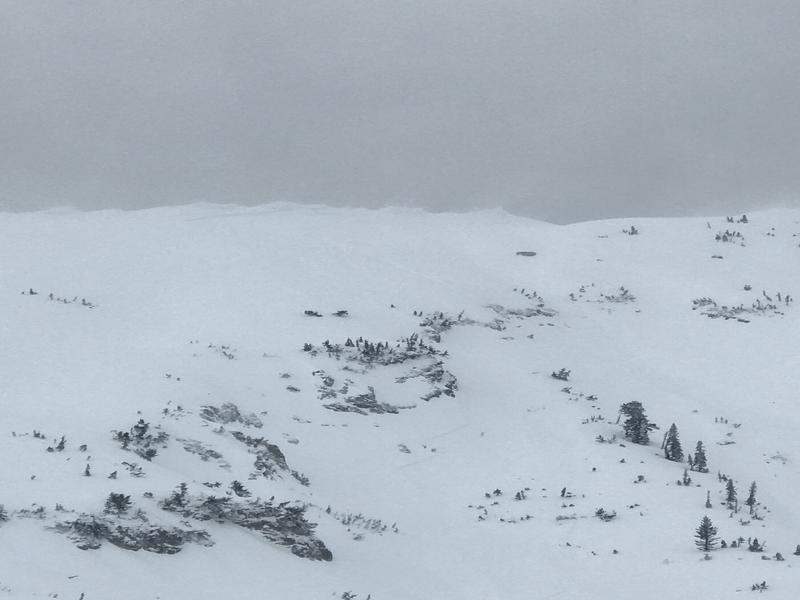
The avalanche danger is CONSIDERABLE at upper elevations where you are likely to trigger a wind-drifted snow avalanche near ridgetops and on the leeward side of terrain features. These wind-drifts may be covered over by new snow, will be hard to see, and could break above you.
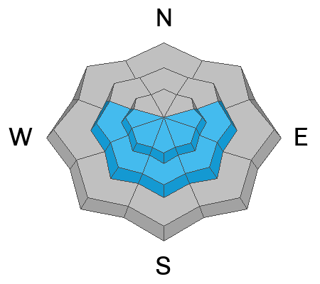
Mid and low elevation slopes have a MODERATE avalanche danger. There is a thin layer of facets associated with a crust now buried 1'-2' deep. We have been seeing avalanches triggered on this layer primarily on east-southeast and west facing aspects.

Careful snowpack evaluation, cautious route-finding, and conservative decision-making will be essential today and if in doubt travel on terrain less than 30 ° in steepness.
Low
Moderate
Considerable
High
Extreme
Learn how to read the forecast here
Special Announcements
Join the UAC and Inspired Summit Adventures for the grand opening of our new Transceiver Training Park at Pinebrook, Sunday, February 25, from 3:00-6:00PM.
Weather and Snow
This morning, under overcast skies trailhead temperatures are in the low 30's° F and the highest ridgelines are in the low 20's °F. Winds are blowing from a southerly direction 10 gusting to 15 MPH. Overnight we received 10"-13" of snow with .86"-1.27" of water weight.
Today, look for overcast skies, mild temperatures 36°-40° F and winds blowing from the south-southwest 15 gusting to 30 MPH at the lower ridgelines and southerly 30 gusting to 45 MPH at the highest ridgelines with isolated gusts to 55 MPH. We can expect to see intermittent snow showers through the day with 1"-3" of new snow and .1"-.35" of water by late afternoon. This may fall as rain below 7500'. There is a chance of lightning and periods of increased precipitation where we might go over on our snow and water numbers in some locations.
Our partners at the National Weather Service have issued a Winter Weather Advisory through 10pm Wednesday night.
Recent Avalanches
We had reports of a large natural wind-drifted snow avalanche on Ben Lomond with a crown up to 4' deep running 1200' vertical. Over the weekend there was a skier triggered avalanche on a southeast aspect in Hells Canyon.
Ad
Avalanche Problem #1
Wind Drifted Snow
Type
Location
Likelihood
Size
Description
Expect to see wind-drifts that could be 12"-36" deep and up to 150' wide. You may not see signs of wind-drifted snow, such as pillow-shaped deposits as they will be buried under the newest snow. There was a large natural wind-drifted snow avalanche reported from Ben Lomond. Cornices are a sign of wind-loading and may be sensitive today breaking further back than you expect.
Photo of crown face on Ben Lomond ( T. Gregory)
Avalanche Problem #2
Persistent Weak Layer
Type
Location
Likelihood
Size
Description
A weak interface made up of a crust with small facets above it has been found on east-southeast and west aspects and maybe found on southerly aspects at mid and upper elevations. This crust is now buried 2' deep. The stubborn and unpredictable nature of this layer means you may trigger an avalanche on this layer remotely. This avalanche problem is spotty-meaning that a snowpit in one location may not tell you if the slope you want to travel on has this buried layer. Assess each slope individually before committing to steep terrain on these aspects. Cracking and collapsing are signs that this layer is present. The tricky part is that this layer is buried on slopes we normally consider "safer".
Avalanche Problem #3
Wet Snow
Type
Location
Likelihood
Size
Description
Warm temperatures and a rain line to 7500' means we may see wet loose avalanches today. Roller balls, pinwheels, and sinking down into the surface snow are signs of instability. If the snow is saturated move to cooler snow at a higher elevation.
Additional Information
Mark describes how to identify thin facets above a crust on aspects where we don't normally see avalanches. The Ogden Area Mountains have more snow (thicker slab) over this weak layer.
General Announcements
This information does not apply to developed ski areas or highways where avalanche control is normally done. This forecast is from the U.S.D.A. Forest Service, which is solely responsible for its content. This forecast describes general avalanche conditions and local variations always occur.