Forecast for the Ogden Area Mountains

Dave Kelly
Issued by Dave Kelly for
Monday, February 19, 2024
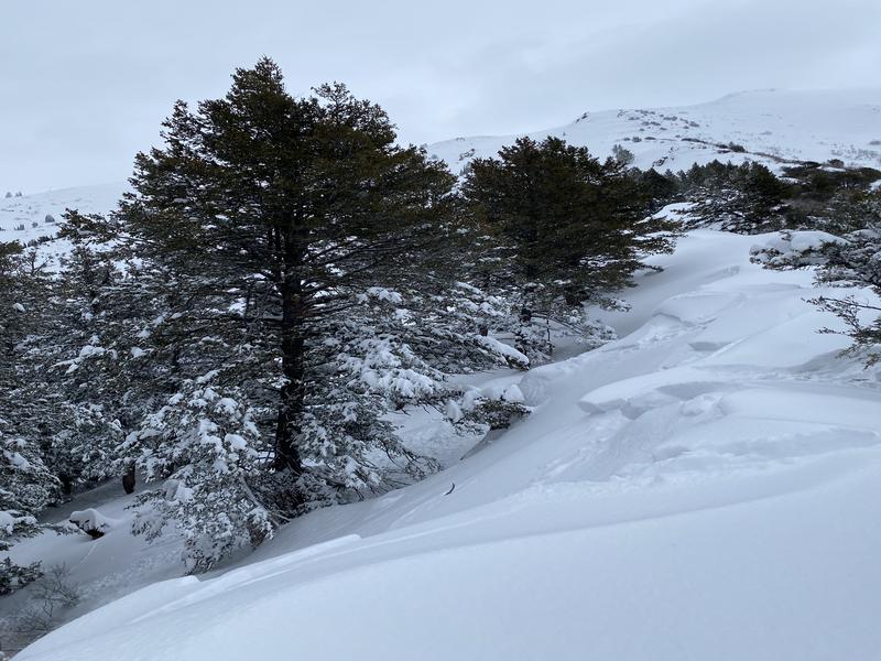
The avalanche danger is CONSIDERABLE at upper elevations where it may be possible to trigger a wind-drifted snow avalanche near ridgetops and on the leeward side of terrain features.
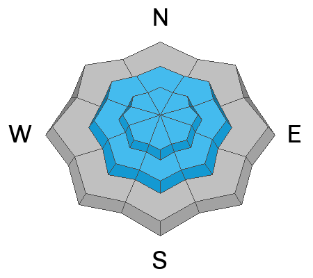
Mid-elevation slopes have a MODERATE danger where we have had reports of avalanches failing on a new/old snow interface that was buried on Valentine's Day. This storm interface has been associated with a crust in many locations and we have seen avalanches failing 12" deep on southeast aspects. This avalanche problem is spotty-meaning that a snowpit in one location may not tell you if the slope you want to travel on has this buried layer. Dig on slopes you wish to travel on to determine if this interface is present.

Sunny skies and filtered clouds could warm the snow surface particularly at lower elevations out of the wind zone, where you could see wet loose avalanche activity on the snow surface.
Careful snowpack evaluation, cautious route-finding, and conservative decision-making will be essential today and if in doubt choose terrain less than 30 ° in steepness.
Low
Moderate
Considerable
High
Extreme
Learn how to read the forecast here
Special Announcements
We are seeking a passionate individual to join us as Executive Director of the nonprofit Utah Avalanche Center. Click here for more information.
Weather and Snow
This morning, under partly skies temperatures are in the 20's° F. Winds are blowing from the south-southwest 15 gusting to 20 MPH at the lower ridgelines and from the south 20 gusting to 35 MPH on Mt. Ogden. Last night's storm cleared out with one final burst of snow for most of the forecast region with accumulations of 4"-6" of snowfall and .7"-.85" of water. Yesterday there were reports of great travel on all aspects.
Today, will start out with clear skies, mild temperatures 39°-42° F and winds blowing from a southerly direction 25 gusting to 30 MPH at the 8,000' ridgelines and blowing from the southeast 30 gusting to 40 MPH at the 9,000' ridgelines. Clouds will increase this afternoon as wind speeds ramp up and we can look for 1"-2" of new snow and .10"-.20" of water by late afternoon. As the sun moves out and the clouds move in you may experience some green-housing on all aspects and elevations which could lead to wet loose avalanches.
Our partners at the National Weather Service have issued a Winter Weather Advisory from 5pm this afternoon through 10pm Wednesday night. Read more HERE.
Recent Avalanches
Yesterday we had reports of wind-drifted snow avalanches near ridgelines and soft slab avalanches within the newest snow on steeper terrain.
Ad
Avalanche Problem #1
Wind Drifted Snow
Type
Location
Likelihood
Size
Description
As winds increase throughout the day expect to see sensitive slabs of wind-drifted snow on all upper-elevation and mid-elevation terrain features. These drifts could be 6-24 inches deep and up to 150 feet wide. Watch out for signs of wind-drifted snow, such as pillow-shaped deposits, and avoid those slopes. Cornices are a sign of wind-loading. Watch for traffic below you before tickling any fresh cornices and be careful as they could break further back than you expect.
L. Bell photo of wind-drifted snow avalanche associated with a cornice near Thurston Peak.
Avalanche Problem #2
New Snow
Type
Location
Likelihood
Size
Description
The Valentine's Day storm buried facets, weak stellar crystals, and surface hoar on many slopes. The Ogden Area Mountains reported 24" of new snow during this storm and while many of the new snow instabilities have settled out, we are still looking at an interface found on east and southeast facing aspects that has small grained facets above a melt-freeze crust where you may be able to trigger avalanches remotely. Forecaster Greg Gagne did not find it in his travels near Ben Lomond, but S. Crowe and A. Budge mentioned finding it on Cutler Ridge. This variability shows us just how spotty this layer can be. Dig down before committing to steeper terrain as it may not be on every slope.
Photo of a soft slab avalanche that failed on a new/old snow interface above a melt-freeze crust in Hells Canyon.
Avalanche Problem #3
Wet Snow
Type
Location
Likelihood
Size
Description
Warm temperatures and sunny skies this morning will increase the likelihood of seeing wet loose avalanches entraining the newest storm snow. This will be more likely in locations out of the wind zone. If you start to see snow falling off of rocks or loose wet snow on steep terrain it's time to move to colder snow.
Many roofs in mountain neighborhoods are still capped with storm snow and we may see some of these roof lines shedding this snow today. Keep an eye out for children playing or adults working around the house as they may be impacted by snow sliding off of roofs.
General Announcements
This information does not apply to developed ski areas or highways where avalanche control is normally done. This forecast is from the U.S.D.A. Forest Service, which is solely responsible for its content. This forecast describes general avalanche conditions and local variations always occur.