Forecast for the Ogden Area Mountains

Dave Kelly
Issued by Dave Kelly for
Tuesday, February 13, 2024
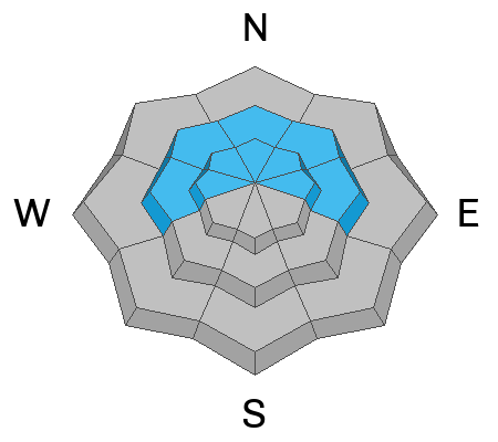
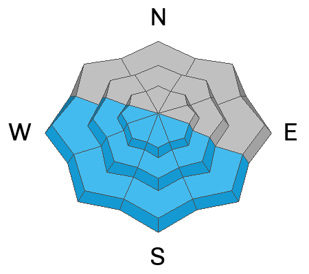
Today, the avalanche danger is MODERATE at mid and upper elevations where it will be possible to trigger either a wet loose avalanche with solar warming throughout the day; or a wind-drifted snow avalanche near ridgetops.
The avalanche danger is LOW in the lowest elevation terrain.
Low
Moderate
Considerable
High
Extreme
Learn how to read the forecast here
Weather and Snow
This morning, under clear skies temperatures are in the mid to high 20's °F. Winds are blowing from a southerly direction 10 gusting to 15 MPH at the 8,000' ridgelines and 25 gusting to 30 MPH at Mt Ogden. There was no new snow overnight and cold clear conditions led to faceting of the surface snow.
For today, look for partly cloudy skies with temperatures from 36-40°F. Winds will blow from a southwesterly direction 5 gusting to 10 MPH at the 8,000' ridgelines and 20 gusting to 30 MPH at the 9,000' ridgelines. No new snow is forecast for today.
Yesterday there were reports of dry loose avalanches running in the surface snow and of wind-drifted snow isolated to the ridgelines. Cornices are a sign that the slope below has been wind-loaded and in some cases the combination of wind-drifted snow and the buried facets could make for large avalanches that would be unsurvivable if you were to be involved. Cold temperatures over the last week have maintained great travel conditions and there is still great riding on shady aspects less than 30 °.
Recent Avalanches
There were no backcountry reports from the Ogden Area yesterday. Ski resorts reported isolated areas of wind-drifted snow near ridgetops.
Read all the observations HERE.
Ad
Avalanche Problem #1
Persistent Weak Layer
Type
Location
Likelihood
Size
Description
The last reported observation from Ogden commenting on the buried PWL was D. Turner from the North Ogden Divide on February 8th and the last reported backcountry avalanche on this layer was January 20th in Black Canyon. Our partners last reported avalanches failing on this layer on February 6th in thin rocky repeater zones. We are seeing less activity on the buried PWL with reports of rounding facets which is good for moving forward. Check out D. DeBruin's observation HERE.
Steep, shallow, and rocky terrain features, or areas that have previously avalanched are still suspect to have avalanches failing near the ground on a layer of buried facets. Dig down into the snow to see if this layer is present before committing to a steeper objective. If you find somewhere that seems to be or not to be healing submit an observation HERE.
Avalanche Problem #2
Wet Snow
Type
Location
Likelihood
Size
Description
With today's warm temperatures and the bright Utah sun solar facing aspects (southeast-south-west) will start to shed snow. Watch for snow falling off rocks and stay out of steep gully features as the day warms up. Roof-lines that are still holding snow may start to shed today. Be aware of children playing or adults shoveling solo or working around the house as they are the most vulnerable to roof slides.
General Announcements
This information does not apply to developed ski areas or highways where avalanche control is normally done. This forecast is from the U.S.D.A. Forest Service, which is solely responsible for its content. This forecast describes general avalanche conditions and local variations always occur.