Forecast for the Ogden Area Mountains

Dave Kelly
Issued by Dave Kelly for
Monday, February 12, 2024
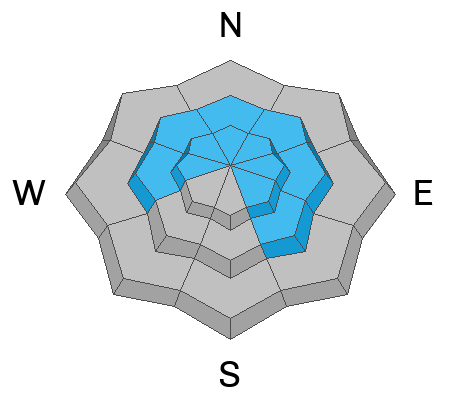
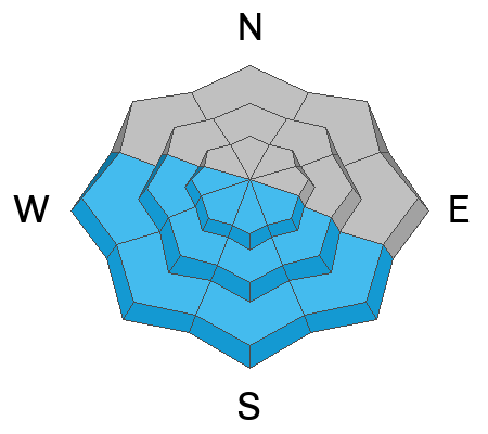
Today the avalanche danger is MODERATE for the Ogden area mountains at mid and high elevations in terrain steeper than 30 ° and LOW in the lowest elevation terrain. Slab avalanches may fail in a persistent weak layer up to 3'- 5' deep in isolated rocky terrain features.
Warmer temperatures today may lead to wet-loose avalanches on lower elevation sunny slopes.
Avoid wind-drifted snow along the highest ridgelines.
Low
Moderate
Considerable
High
Extreme
Learn how to read the forecast here
Weather and Snow
This morning, under partly cloudy skies trailhead temperatures are in the mid-teens °F, the highest ridgelines are in the low-teens °F. Winds are blowing from a westerly direction 20 gusting to 30 MPH at the 9,000' ridgelines. There was no new snow overnight and cold clear conditions led to faceting of the surface snow.
For today, look for partly cloudy skies with temperatures from 34-37°F. Winds will blow from a westerly direction 5 gusting to 10 MPH at the 8,000' ridgelines and 20 gusting to 30 MPH at the 9,000' ridgelines. Winds are forecast to increase throughout the day. No new snow is forecast for today.
Cold temperatures over the last week have led to blower travel conditions and there is still great riding on higher elevation and shady aspects less than 30 ° that haven't been sun-affected.
Recent Avalanches
Yesterday there were reports of wet loose avalanches on due south facing terrain in Black Canyon and wind-drifted snow at the highest ridgelines.

This was an active avalanche weekend in the backcountry south of Ogden. Some stand out avalanches are listed below:
  • Skier triggered-Broads Fork Twins-Lisa Falls 11,200 Southeast Aspect- Wind-drifted snow avalanche 2' deep - ran 1500' vertical-Helicopter Evacuation
  • Unknown trigger-Main Gobblers - Millcreek Canyon - 9800' - Northwest Aspect - Hard slab failing on facets 5' deep - 400' wide - ran 2000' vertical
  • Skier triggered-Cardiac Ridge - Cardiff Fork - 10,800' - East Aspect - Hard slab failing on facets 3.5-4' deep - 350' wide-ran 1000' vertical
  • Snowboarder triggered-Pioneer Ridge- Toilet Bowl- 10,200'- North Aspect- Hard slab failing on facets 3' deep-70' wide-ran 200' vertical
    Read all the observations HERE.
Ad
Avalanche Problem #1
Persistent Weak Layer
Type
Location
Likelihood
Size
Description
Steep, shallow, and rocky terrain features, or areas that have previously avalanched are most suspect to have avalanches failing near the ground on a layer of buried facets. The PWL in the Ogden area is less in your face and we have heard of less activity on this layer than further south. Collapsing and whumpfing are signs of instability and these red flags may or may not be present prior to an avalanche failing on a persistent weak layer. Dig down into the snow to see if this layer is present before committing to a steeper objective.
Avalanche Problem #2
Wet Snow
Type
Location
Likelihood
Size
Description
With today's continued warming temperatures and the bright Utah sun solar facing aspects (southeast-south-west) will start to shed snow. Watch for snow falling off rocks and stay out of steep gully features as the day warms up. Roof-lines that are still holding snow may start to shed today. Be aware of children playing or adults shoveling solo or working around the house as they are the most vulnerable to roof slides.
Avalanche Problem #3
Wind Drifted Snow
Type
Location
Likelihood
Size
Description
There is a lot of snow available for transport on shady aspects and at the highest ridgelines. Yesterday there was a close call in the Central Wasatch involving a very lucky solo skier in Lisa Falls that was caught in a wind-drifted snow avalanche that took him for a 1500' ride over cliff band. You may find similar areas of wind-drifted snow near ridgetops in the Ogden area mountains.
Look for and avoid rounded pillowy areas of drifted snow. These will most likely be close to or below ridgelines on all aspects and while they may not be big enough to bury you, they are more than enough to take you for a violent ride down the hill. Cornices are a great sign that the slope below has been wind-loaded and in some cases the combination of wind-drifted snow and the above mentioned PWL problem could make for large avalanches that would be unsurvivable if you were to be involved.
General Announcements
This information does not apply to developed ski areas or highways where avalanche control is normally done. This forecast is from the U.S.D.A. Forest Service, which is solely responsible for its content. This forecast describes general avalanche conditions and local variations always occur.