Fall Auction is now live! Check it out now

Forecast for the Ogden Area Mountains

Drew Hardesty
Issued by Drew Hardesty on
Saturday morning, December 31, 2022
DANGEROUS AVALANCHE CONDITIONS
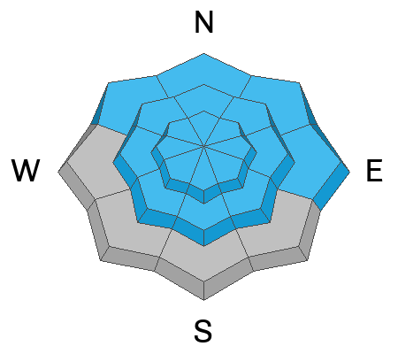
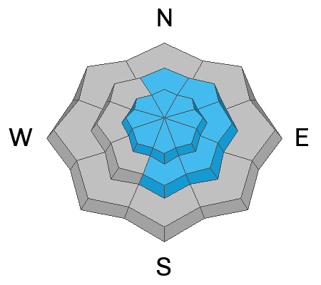
The avalanche danger will reach HIGH today on many slopes of the mid and upper elevations. Natural and human triggered new snow or wind-drifted snow avalanches are likely. On northwest through easterly facing aspects, avalanches may step down into older weak layers, leading to large and destructive avalanches.
Travel Advice: Travel in avalanche terrain is not recommended. I would also avoid traveling beneath large avalanche paths as well.

The danger in the Provo mountains is - or will soon reach - EXTREME.
Low
Moderate
Considerable
High
Extreme
Learn how to read the forecast here
Avalanche Warning
...THE FOREST SERVICE UTAH AVALANCHE CENTER IN SALT LAKE CITY HAS ISSUED A BACKCOUNTRY AVALANCHE WARNING WHICH IS IN EFFECT FROM 6AM MST SATURDAY TO 6AM MST MONDAY...
* WHAT...The avalanche danger is expected to reach High. The danger may reach Extreme in the Provo area mountains.
* WHERE...For the mountains of northern and central Utah, to include southeast Idaho. This includes the Wasatch Range, the Bear River Range, the Western Uintas, and the Manti-Skyline Plateau.
* WHEN...In effect from 6am MST Saturday morning to 6AM MST Monday morning. * IMPACTS...Very dangerous avalanche conditions exist. With heavy snowfall and strong wind, both natural and human triggered avalanches are likely on many slopes. Stay off of and out from under slopes steeper than 30 degrees.
* PRECAUTIONARY/PREPAREDNESS ACTIONS... Stay off of and out from under slopes steeper than 30 degrees.
Weather and Snow
Storm totals thus far are 8-10" with up to 1.20" snow water equivalent.
Temperatures, currently in the upper 20s to low 30s, have risen during the storm. Winds are westerly, blowing 25-30mph with gusts to 40mph. Along the highest elevations, they are gusting to 60mph+.
We'll see continued snowfall, heavy at times, during the day. Winds should remain moderate to strong and shift to the southwest. Temperatures will be in the upper 20s...and rising. We may see another foot of heavy dense snow today. This is a long, prolonged event and we won't see cooler air and lower density snow until later Sunday eve.
Recent Avalanches
A very close call occurred on the Rodeo Ridge area in the north fork on the 28th. The excellent write up is HERE>.
Ad
Avalanche Problem #1
Persistent Weak Layer
Type
Location
Likelihood
Size
Description
This heavy snowfall and wind event will be a significant test of our buried November persistent weak layer (PWL). This storm will add significant stress to these layers, particularly with any other new snow avalanche stepping down to these old layers, creating large and tree snapping avalanches. At lower elevations, the poor structure still exists and remains suspect, particularly with additional rain today.
Avalanche Problem #2
New Snow
Type
Location
Likelihood
Size
Description
Continued heavy snowfall rates, rising and then fluctuating rain/snow lines will increase the avalanche danger today on all aspects and elevations. I expect rising sensitivity and size of both soft slab avalanches and dry loose avalanches within the new snow of all aspects at the mid and upper elevations.
Any heavy rain on dry snow will lead to unstable avalanche conditions in the low elevation bands.
Avalanche Problem #3
Wind Drifted Snow
Type
Location
Likelihood
Size
Description
Sensitive soft slabs of wind blown snow will be found on steep slopes of the mid and upper elevations, predominantly on north to east to south facing slopes. Some of these will run naturally.
These can be found well off the ridgelines and around other terrain features. Cracking is a clear sign of instability. Avoid steep terrain with fresh wind drifts.
General Announcements
Help support the UAC while doing your Holiday Shopping. The UAC's Holiday Silent Auction opens at 8:00 AM MT on December 26 and will close at 8:00 PM MT on January 2. Take a look at items and bid HERE.

This information does not apply to developed ski areas or highways where avalanche control is normally done. This forecast is from the U.S.D.A. Forest Service, which is solely responsible for its content. This forecast describes general avalanche conditions and local variations always occur.