Forecast for the Ogden Area Mountains

Mark Staples
Issued by Mark Staples for
Wednesday, November 30, 2022
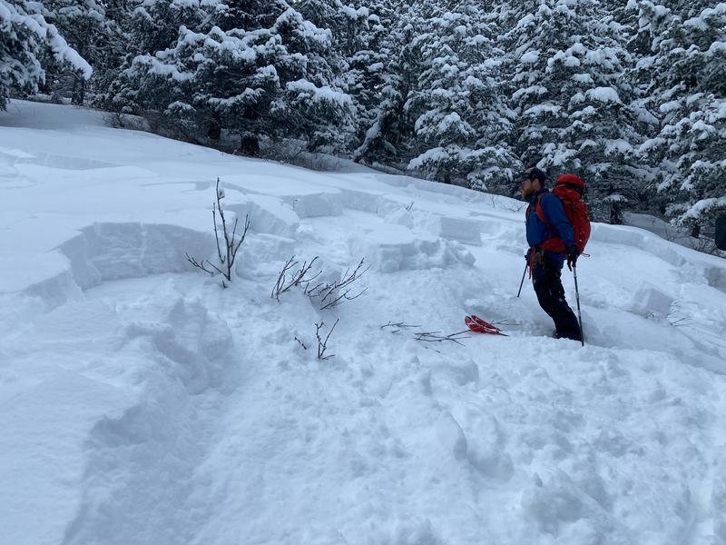
The biggest and most dangerous avalanches will be at upper elevations on slopes with wind drifted snow where the avalanche danger will be CONSIDERABLE today. Most of these wind loaded slopes have a cohesive slab of wind drifted snow resting on a persistent weak layer.
Mid and low elevations have a MODERATE danger with heightened avalanche conditions on any slope loaded by winds which should be increasing from the southwest today. Even on non-wind loaded slopes, you can trigger a soft slab avalanche breaking on a persistent weak layer.
These are serious conditions that will become much more dangerous with strong winds and more snowfall over the next few days. The danger ratings alone don't tell the full story.
Low
Moderate
Considerable
High
Extreme
Learn how to read the forecast here
Special Announcements
Join the Utah Avalanche Center and the Utah Division of Outdoor Recreation to celebrate the Fourth Annual Avalanche Awareness week, from December 4 - December 11. Click HERE to view the full list of events for the week.
Weather and Snow
The storm ended yesterday around 9 a.m. with total snowfall amounts of 12 - 23 inches of snow (1-1.17 inches of water).
This morning, temperatures are hovering mostly in the mid to upper teens F. Winds have increased since yesterday and are blowing 12-27 mph with gusts up to 37 mph from the southwest.
Today will be noticeably warmer than yesterday with temperatures rising into the mid and upper 20s F. Lower elevations will have temperatures near freezing. Winds from the southwest will increase this afternoon averaging 20-30 mph with gusts at upper elevations reaching 55 mph.
Snow conditions and coverage are fantastic, especially for Nov 30th. Total snow depths above 8000 feet are generally 3 feet.

Tomorrow will have even stronger winds from the southwest ahead of another storm with snowfall beginning late tomorrow afternoon. It will be a fast moving storm with a lot of water that could bring similar snow and water amounts as yesterday's storm.

From Ogden to the central Wasatch to the Provo mountains, we have received several excellent observations. You can find them HERE. Please keep these reports coming.
Recent Avalanches
Yesterday from Ben Lomond to Powder Mountain, there were several reports of natural avalanches and big collapses occurring on a layer of buried surface hoar. This is unusual because surface hoar forms often but typically is destroyed by winds or sunshine before it is buried.
There were many slides reported further south near SLC, and I suspect very similar ones could have been triggered in the Ogden area. Below is a photo (S. Thackeray) of one from Mineral Fork in Big Cottonwood Canyon at 7,800 ft.
Ad
Avalanche Problem #1
Wind Drifted Snow
Type
Location
Likelihood
Size
Description
Winds will be increasing from the southwest today and transporting snow to the leeward (or downwind) side of ridges, gullies, and other terrain features. Cohesive slabs of this wind drifted snow will create the largest and most dangerous avalanches today that should be easy to trigger. On most slopes these wind slabs will be resting on a weak layer of faceted snow that formed during two weeks of dry weather in the middle of November.
These wind slabs will cover wide areas, and the most likely places to find them will be upper elevations where southwest winds will be the strongest. However, look for them at mid and low elevations as well. Avoid these slopes.
Avalanche Problem #2
Persistent Weak Layer
Type
Location
Likelihood
Size
Description
Dry and cold weather during the middle two weeks of November created a persistent weak layer (PWL) of facets on nearly all slopes. To make matters worse, there may be a layer of surface hoar (another PWL) on top of these facets. Both layers were capped and loaded 1-2 feet of snow from the storm that ended yesterday.
On slopes that received sunshine and ones at mid and low elevations during a brief warmup around Thanksgiving, there is a fragile ice crust on top of this persistent weak layer. This ice crust doesn't really change the situation except on steep slopes facing due south where the ice crust is much thicker and stronger.
As mentioned above, the biggest and most dangerous avalanches will be on wind loaded slopes because the slab of snow on top of this weak layer is more cohesive and thicker. I still expect avalanches will be triggered on this layer on slopes not loaded by winds, but these slides will be smaller and not break over such wide areas. Warmer temperatures today should help consolidate the new snow, helping it become a more cohesive slab.
General Announcements

This information does not apply to developed ski areas or highways where avalanche control is normally done. This forecast is from the U.S.D.A. Forest Service, which is solely responsible for its content. This forecast describes general avalanche conditions and local variations always occur.