Join us at our 2nd Annual Blizzard Ball

Forecast for the Ogden Area Mountains

Drew Hardesty
Issued by Drew Hardesty on
Tuesday morning, January 7, 2025
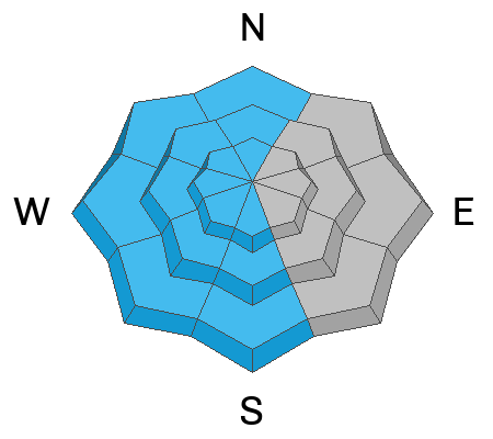
Areas of CONSIDERABLE danger exist on upper elevation northwest through east facing slopes. Here you can trigger 1-3' thick slab avalanches failing on a persistent weak layer of faceted grains. You can trigger these tricky avalanches from a distance or below. A MODERATE danger exists for developing soft slabs of wind-drifted snow at all elevations with today's increasing winds from the EAST.
*If you're heading out of bounds, you are most likely stepping into potentially dangerous conditions.
Low
Moderate
Considerable
High
Extreme
Learn how to read the forecast here
Weather and Snow
Skies are mostly cloudy but trending clear. Mountain temperatures are in teens to low 20s. Wind speeds are10-15mph with gusts to 20mph out of the northeast. The highest ridgelines are likely double that.
For today, we'll have partly cloudy skies, temps in the teens and increasing winds from the east northeast. I've often found the models to sandbag (underplay) the windspeeds from the east and northeast, so keep an eye on more blowing and drifting snow than expected.
Another quick hitting storm arrives Wednesday night that should be more wind than snow with another storm on the horizon over the weekend.
Recent Avalanches
Ski area control teams had mixed results with ski cutting and explosives yesterday with mostly soft slabs triggered within the new snow or as wind slabs. Pockety hard slabs continue to release with explosives.
Ad
Avalanche Problem #1
Persistent Weak Layer
Type
Location
Likelihood
Size
Description
The snowpack sits uneasily with cohesive slabs of snow sitting 1-3 feet thick above a persistent weak layer of sugary grains. These slabs continue to be triggered at the ski areas and remain dangerous in the backcountry. This unstable structure is most pronounced on northwest to east facing slopes at the mid and upper elevations. Caution is required in this terrain.
Avalanche Problem #2
Wind Drifted Snow
Type
Location
Likelihood
Size
Description
This is probably an over-forecast, but I just want you to have blowing and drifting snow on your radar today. There is quite a bit of uncertainty with the forecast of moderate to strong EASTERLY winds but keep an eye not just on increasing winds aloft, but blowing and drifting snow with the gap winds in the canyons; ie - Weber Canyon etc. It could be a bust, but keep an eye on how things play out today.
Additional Information
The accident reports for the Porter Fork and Davenport Hill Accident have been completed. You can read them HERE.
At the Utah Avalanche Center, we strive to learn from every avalanche incident and share insights to help others avoid similar accidents. We have all experienced close calls and understand how easily mistakes can happen. Our goal with these reports is to provide valuable learning opportunities.
General Announcements
This information does not apply to developed ski areas or highways where avalanche control is normally done. This forecast is from the U.S.D.A. Forest Service, which is solely responsible for its content. This forecast describes general avalanche conditions and local variations always occur.