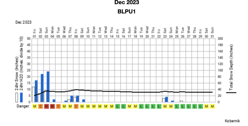
Forecast for the Ogden Area Mountains

Drew Hardesty
Issued by Drew Hardesty for
Thursday, January 4, 2024
There is a generally LOW avalanche danger but conditions will be changing.
Even though we will only see a few inches of new snow today, it will sluff easily in steep terrain. If you're traveling along the ridgelines this afternoon, watch for very shallow, very soft, very sensitive soft slabs. Today's a day to get locked in toward an avalanche mindset. Conditions will start to get tricky and dangerous soon.
Low
Moderate
Considerable
High
Extreme
Learn how to read the forecast here
Special Announcements
New UAC Product! Sign up HERE for forecast region-specific text message alerts. You will receive messages about changing avalanche conditions, watches, and warnings.
Weather and Snow
Skies are overcast with light snow falling in the mountains.
Today and Tomorrow's Big Picture: a larger storm diving to the south provided us some spillover clouds and precipitation out of the southeast, but as it pulls away, we'll shift to our bread and butter cool, moist northwest flow. In other words, we'll see light precipitation (1-3") and light to moderate winds from the northwest today. Temperatures will be in the teens. Another storm on this track (again from the northwest) arrives tomorrow that might be something of a sleeper storm - one that doesn't look all that dramatic on paper, per se, but may end up providing a decent amount of snowfall through Saturday morning; say perhaps 6-10" of cold smoke. Maybe more?
The Outlook: We get a bit of a break Saturday ahead of another strong storm that again dives a bit south but we'll still see some snowfall out of it. I do worry that this storm will bring some strong winds from the east on Sunday, but there are still a few days to work out the details. Next week looks active and stormy as well. Buckle up, it might be a wild and bumpy ride for awhile (more on this below).
Recent Avalanches
None reported. Sluffing in the weak surface snow noted in the SLC mtns.
Ad
Avalanche Problem #1
New Snow
Type
Location
Likelihood
Size
Description
Any new snowfall today will bond poorly to the old snow surfaces on all aspects and sluffing is likely in steep terrain. Along the ridgelines, there may be just enough wind out of the northwest to create the softest of soft slabs that will be sensitive to provocation. Any hazard will be a function of the terrain in which you're traveling: the sluffs and pockets of slab will be enough to knock you off your feet and take you for a ride.
Know also that slide-for-life conditions still exist on steep southerly aspects and some shady aspects where it may be easy to lose footing and continue to slide on the myriad slick crusts.
Additional Information


Look below at the weather and avalanche danger chart from December. (Vertical bars represent snowy days, colored letters denote danger rating.)
A few things at play here: as you well know, it really hasn't snowed much at all for weeks and this has deteriorated/weakened the snow surfaces and fostered the development of surface hoar on many aspects and elevations. I like to say that Idle weather does the devil's work. See Doug Wewer's video of the weak snow surfaces below...or see Will Ambler's observation HERE. It's common to have weak surface snow destroyed or blown away due to sun/temperatures/wind but I fear that today's couple-few inches of new will protect and insulate this weak, fragile and faceted snow ahead of the next series of storms. THIS now makes a bad set-up worse. When we get a cohesive slab of snow, watch out.
There's more to the problem. Because it has been so dry, all of us are capital H hungry for the goods. It may shape up to be the perfect storm of danger and desire. Stay safe out there.


General Announcements
This information does not apply to developed ski areas or highways where avalanche control is normally done. This forecast is from the U.S.D.A. Forest Service, which is solely responsible for its content. This forecast describes general avalanche conditions and local variations always occur.