Forecast for the Ogden Area Mountains

Dave Kelly
Issued by Dave Kelly for
Saturday, January 27, 2024
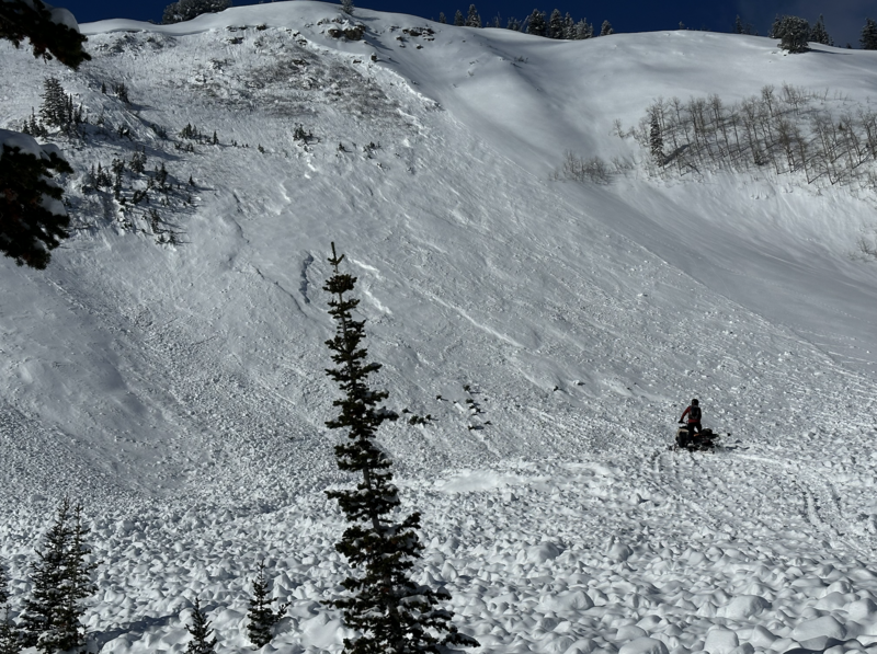
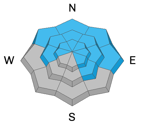
The avalanche danger is MODERATE on all slopes facing northwest through north and east, and mid and upper elevation slopes facing west and southeast. All other slopes have a LOW avalanche danger.
MODERATE danger with a buried persistent weak layer is not a green light nor is it the same as MODERATE danger with another type of avalanche problem. Evaluate snow and terrain carefully to identify thin, rocky, steep areas where slab avalanches may fail in a persistent weak layer buried 2-5' deep.
With today's warming you may see wet avalanche activity on lower or mid elevation slopes out of the wind zone.
Low
Moderate
Considerable
High
Extreme
Learn how to read the forecast here
Special Announcements
Join us for a Motorized Backcountry 101: Introduction to Avalanches class on February 2-3 down on the Skyline. Click HERE for more information.
Weather and Snow
This morning, under partly cloudy skies trailhead temperatures are in the 20's° F while the highest ridgelines are in the high-teens to low 20's °F. Winds are blowing from southwest in the low-teens gusting to the 20's MPH at the 8,000' ridgelines and in the mid 20's gusting to the high 20's MPH from the northwest at the 9,000' ridgelines. There was no new snow overnight.
For today, we should see mostly sunny skies with temperatures from 34-37°F and winds blowing from the north-northwest 10 gusting to 15MPH at the 8,000' ridgelines and 25 gusting to 30 MPH at the 9,000' ridgelines. Winds are forecast to decrease throughout the day.

Looking forward we can expect to see progressively warmer temperatures with clear skies through the middle of the week with the next storm on the horizon for the end of the week. Read more from our partners at the National Weather Service HERE.
Recent Avalanches
There were no reports to the UAC from the Ogden area yesterday. If you're out and about submit an observation HERE.
There was an avalanche reported from Ant Knolls on the northern edge of the Provo Forecast region. This avalanche is representative of what you may find during Moderate danger with a buried persistent weak layer in the Ogden Area mountains.
Photo of Ant Knolls Avalanche (Photo Credit R. Shea)
Click here for all recent observations and avalanches.
Ad
Avalanche Problem #1
Persistent Weak Layer
Type
Location
Likelihood
Size
Description
These avalanches involving buried persistent weak layers are not to be fooled with; if it's a thin snowpack over steep rocky terrain then you're taking a gamble. While the danger may have dropped from Considerable to Moderate the mountains don't care what the avalanche forecast is. For today, I will still be assessing terrain and avoiding zones that are steep and rocky with dry facets now buried close to the ground as these are the areas where you are more likely to trigger an avalanche.
If you choose to venture into steeper terrain:
  • Continually evaluate the snowpack looking for thinner areas where it may be easier to trigger an avalanche in the buried PWL
  • Avoid steep, rocky slopes where the snowpack is likely to be thinner
  • Back off of steep slopes when red flags are present, such as collapsing or recent avalanches
Additional Information
Nikki and Greg discuss the forecaster mindset when moving to a Moderate Danger with a buried Persistent Weak Layer (PWL)
Eric Trenbeath (Moab Avalanche Forecaster) put together a great blog discussing Moderate Danger with a buried Persistent Weak Layer. Read it HERE.
General Announcements
This information does not apply to developed ski areas or highways where avalanche control is normally done. This forecast is from the U.S.D.A. Forest Service, which is solely responsible for its content. This forecast describes general avalanche conditions and local variations always occur.