Forecast for the Ogden Area Mountains

Nikki Champion
Issued by Nikki Champion for
Wednesday, January 25, 2023
The avalanche danger is MODERATE on all upper-elevation slopes where freshly formed wind drifts are the primary concern. The avalanche danger is LOW on mid and lower-elevation slopes where there has been overall less wind and less snow. Small, long-running sluffs are also possible in steep, sustained terrain.

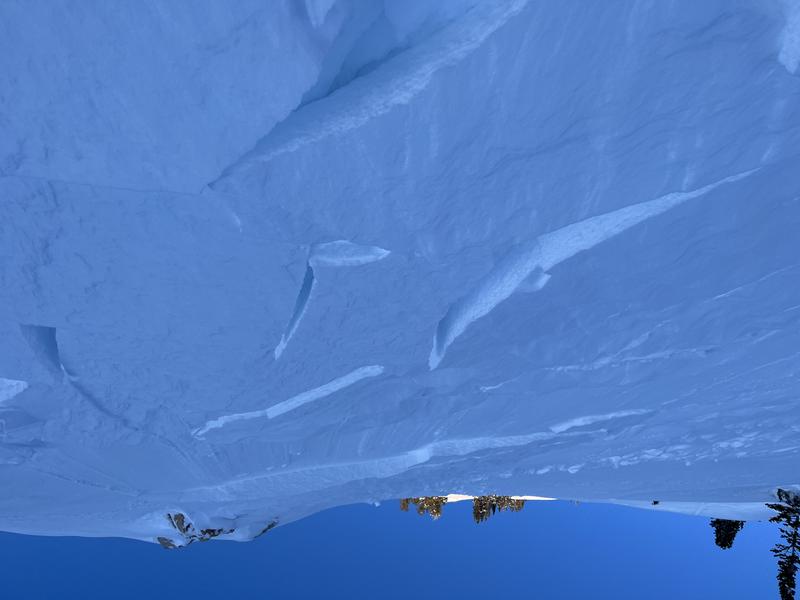
Cornices continue to grow in size. Avoid traveling below or along corniced ridgelines as they can break further back than you might expect.
Low
Moderate
Considerable
High
Extreme
Learn how to read the forecast here
Weather and Snow
This morning, it is lightly snowing. Temperatures are in the low teens F and winds are blowing from the north-northwest between 10-15 mph with gusts up to 40 mph at the highest ridgelines. Overnight 1-2" of new snow fell.
Today, skies will become mostly cloudy. There is a small chance for another trace to 2" of snow before mid-morning. Temperatures will climb into the mid-20s F. Winds will remain north northwesterly, averaging 5-15 mph with gusts up to 30 mph.

Small loose avalanches are possible in steep terrain at all elevations. If the sun comes out look for warming on any solar aspect at mid and lower elevations and avoid traveling underneath these slopes as an avalanche in steep rocky terrain could lead to an injury.
Recent Avalanches
Yesterday there were reports of small sensitive wind drifts along upper-elevation terrain and ridgelines.

Catch up on backcountry observations HERE.
Ad
Avalanche Problem #1
Wind Drifted Snow
Type
Location
Likelihood
Size
Description
The elevated winds will continue to form sensitive slabs of wind-drifted snow along upper-elevation ridgelines and mid-elevation terrain features that allow for drifting snow to accumulate. Variable wind directions over the last few days will have loaded snow onto all aspects.
Look for cracking, collapsing, and rounded pillows of new snow, and avoid steep terrain where you could trigger them.
These wind-drifted snow avalanches may entrain snow on steeper slopes, and could be more than enough to take a rider off their feet. Even a small avalanche can be consequential in hazardous terrain.

Wind-drifted avalanche on a south facing slope at 9,200' (Photo-Karol)
Cornices continue to grow in size and will be sensitive today and may break further back than you anticipate. Give them a wide berth.
General Announcements
This information does not apply to developed ski areas or highways where avalanche control is normally done. This forecast is from the U.S.D.A. Forest Service, which is solely responsible for its content. This forecast describes general avalanche conditions and local variations always occur.