Forecast for the Ogden Area Mountains

Drew Hardesty
Issued by Drew Hardesty for
Tuesday, January 23, 2024
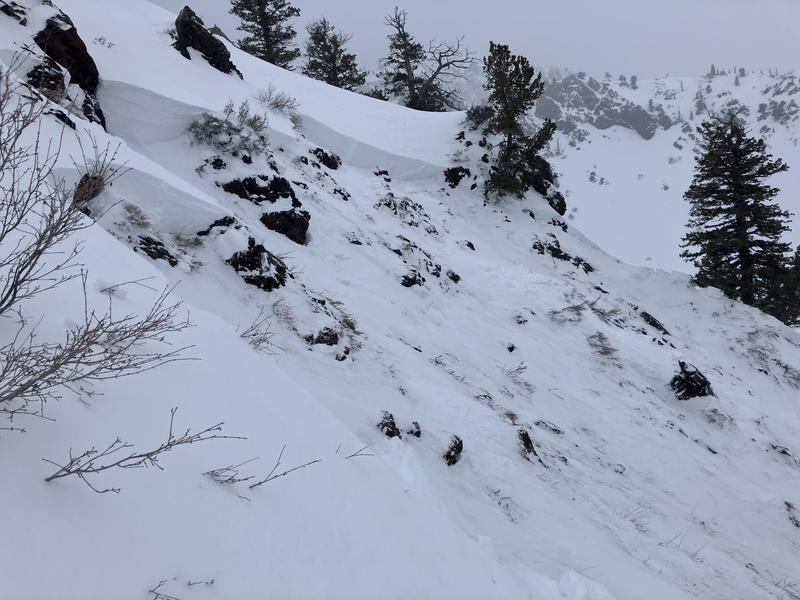
The avalanche danger is CONSIDERABLE on many west to north to southeast facing slopes. Dangerous and tricky avalanche conditions exist. Cautious route-finding and conservative decision making is essential. Essential to what? - Essential to making it back to the trailhead at the end of the day. Be careful out there.
Remember if you're stepping out of bounds at a ski area, you are stepping into CONSIDERABLE danger.
Low
Moderate
Considerable
High
Extreme
Learn how to read the forecast here
Weather and Snow
Skies are mostly cloudy. Mountain temps are in the upper 20s to low 30s; winds are light from the southeast. I expect a marginal refreeze in the low elevations; the snow may be punchy and poorly consolidated.
We do have a weak storm on tap for this evening, but at least it'll split around us. But all seriousness aside, we'll see a trace to 2" of new with a stronger storm slated for Thursday. Thursday's storm should offer an additional 3-6" - a nice refresh.
For today, we'll have mostly cloudy skies trending overcast with a few flakes early afternoon. Temps will be in the mid-30s. Winds will be light from the southeast, then shift around to blow 10-15mph from the northwest.
The Outlook: high pressure builds for the weekend with a warming trend on tap. And I do mean warm. The models suggest we could see mountain temps into the 40s and higher for early next week. We'll see.
Recent Avalanches
The most recent reported slide in the Ogden mountains was from Saturday off Island Peak near Ben Lomond. This large and significant avalanche broke 3' deep and 70' wide on a steep northeast facing slope at 8400'. DETAILS
Ad
Avalanche Problem #1
Persistent Weak Layer
Type
Location
Likelihood
Size
Description
Your main concern is triggering a large and unsurvivable hard slab avalanche that fails on weak faceted snow 2-5'+ deep. This weak faceted snow is a persistent weak layer that formed during our extended dry spell in December and was subsequently buried on January 4th. The initial indicator avalanche of this newly buried PWL was just two days later on the 6th in Main Porter Fork of MCC in SLC with an upward trend of avalanche activity with additional storms the following week. The world fell apart with an Extreme danger on Sunday Jan 14th with widespread avalanches on many aspects and elevations. Over time, this unstable combination has become more stubborn and yet they are no less deadly. Below is an avalanche frequency chart since Jan 6th for all regions.

Beyond all the highlight reel avalanches are some booby-trap avalanches that have recently caught my eye from last Thursday and Friday. These PWL avalanches are well off the ridgelines and in the mid-elevation (some low elevation) bands but still large enough to catch, carry, and bury you. Don't let your guard down. Slope angle is slope angle.
Additional Information

Forecaster's Corner: Skiing and riding the backcountry during a Considerable avalanche danger that harbors a PWL is tricky. Usually the snow is great and the signs of instability are not as apparent and obvious as during High or Extreme danger. In spite of our better judgment, we can get lured out into steep terrain by other tracks and even get away with a run or two. But it's when most of our accidents and fatalities occur. Over 70% of our fatalities involve a persistent weak layer. If you get caught and carried today, where will you go? What will happen?
General Announcements
This information does not apply to developed ski areas or highways where avalanche control is normally done. This forecast is from the U.S.D.A. Forest Service, which is solely responsible for its content. This forecast describes general avalanche conditions and local variations always occur.