Forecast for the Ogden Area Mountains

Dave Kelly
Issued by Dave Kelly for
Monday, January 23, 2023
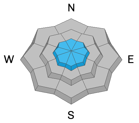
The avalanche danger is MODERATE on upper-elevation slopes where you may trigger small wind-drifted snow avalanches. The avalanche danger is LOW on mid and lower elevation slopes where there is less wind-drifted snow.

Don't get caught in any avalanche regardless of size in a place where you don't want to go; such as over a cliff band, or through a stand of trees.

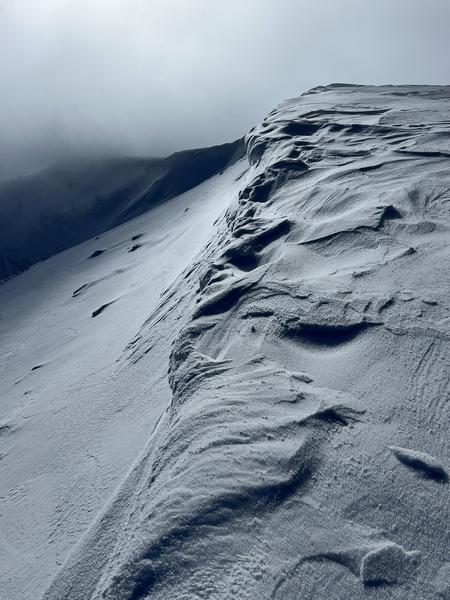
Small loose dry avalanches are possible in steeper terrain at all elevations.
Low
Moderate
Considerable
High
Extreme
Learn how to read the forecast here
Weather and Snow
Under clear skies temperatures are in the single digits F. Winds are primarily blowing from an easterly direction 30 gusting to 65 MPH at the highest ridgelines. Mountain operations teams reported 1-2" of new snow in the last twenty-four hours. For today, winds will blow strong from the east before decreasing in speed and turning more northerly. Skies will be partly cloudy with mountain temperatures 23-27 F. No new snow is expected today.

Looking ahead, cold northwest flow with a chance for light snow on Tuesday.

UAC Forecaster Greg Gagne's observation from Ben Lomond talks about the weakening of the surface snow. Any new wind-drifted snow that lands on this weak surface snow will be a place where a rider could easily trigger an avalanche.
Recent Avalanches
There were no reports of avalanche activity from the Ogden backcountry yesterday. Catch up on backcountry observations HERE.
Ad
Avalanche Problem #1
Wind Drifted Snow
Type
Location
Likelihood
Size
Description
Areas of wind-drifted snow will be more sensitive today than yesterday with winds now blowing from the east. These areas of wind-drifted snow will be easily recognizable as you will see smooth and rounded deposits. Look for clues of instability such as cracking and avoid steep slopes where you may trigger soft or hard slabs of wind-drifted snow. Cornices will be sensitive today and I would avoid traveling underneath these cornices or close to the edge of corniced ridgelines.
Photo- B. Smith of east winds transporting snow to the opposite side of the ridge.
Additional Information
General Announcements
This information does not apply to developed ski areas or highways where avalanche control is normally done. This forecast is from the U.S.D.A. Forest Service, which is solely responsible for its content. This forecast describes general avalanche conditions and local variations always occur.