Forecast for the Ogden Area Mountains

Dave Kelly
Issued by Dave Kelly for
Tuesday, January 17, 2023
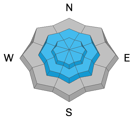
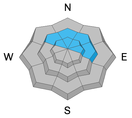
The avalanche danger is CONSIDERABLE at upper elevations where there will be more wind drifting. You can expect to trigger avalanches in the new snow on all aspects. The avalanche danger is MODERATE at mid and lower elevations where there has been less new snow.

With increased snowfall rates throughout the day, I would expect to see natural and human triggered avalanches running on density changes in the new snow.
Low
Moderate
Considerable
High
Extreme
Learn how to read the forecast here
Weather and Snow
It's snowing at most mountain locations. Overnight, the Ogden area mountains reported 4-6" of new snow. Trailhead temperatures are in the mid 20's F and the 9,000' temperatures are in the high teens F. Winds are calm blowing from the south and south east at the lower elevations and blowing lightly from the southeast at the higher ridgelines.
Today will bring continued snowfall, heavy at times, 1-3" expected. Temperatures will be 28-32 F. Winds will veer to the north-northwest 15 gusting to 30 MPH at the 9,000' ridgelines.

Snowfall and total snow depths for the last two weeks
  • Ogden Area Mountains- 75" snow (snow depth 90-110")
Recent Avalanches
Yesterday backcountry travelers reported good skiing at low and mid-elevations. Read more about why they stuck to those slopes HERE.

Check out the observations from yesterday HERE.
Ad
Avalanche Problem #1
New Snow
Type
Location
Likelihood
Size
Description
It just keeps snowing. With today's forecasted new snow falling on last night's low density fluff expect to see loose dry and soft slab avalanches running on density changes today.

Use caution and watch for easily triggered new snow avalanches while ascending and descending steep slopes. Travel one at a time through steep terrain over 30 degrees and think about not IF you'll see a new snow avalanche, but where it might take you if you are swept off your feet.
Avalanche Problem #2
Wind Drifted Snow
Type
Location
Likelihood
Size
Description
Very light snow only needs very light winds to transport it around the mountains. At higher elevations soft slabs of wind drifted snow may crack out upon approach or under your skis. These wind drifted snow avalanches may entrain all of last night and today's new snow and on steeper slopes will be more than enough to take a rider off their feet.

Cornices will be sensitive today and may break further back than you anticipate.
Avalanche Problem #3
Persistent Weak Layer
Type
Location
Likelihood
Size
Description
The PWL is deeply buried and it would require a significant trigger (a medium size avalanche, large cornice, or a series of powerful sustained storms with winds) to avalanche. If an avalanche breaks on this layer it would be 6-10' deep and up to 3,000' wide. An avalanche on this PWL would be very hard to trigger and un-survivable if a human was caught in a slide of this size.

You may notice us chipping away at the PWL layer in the avalanche rose. Do we think that humans will trigger an avalanche on this November PWL today? Probably not- but with continued new water weight and wind the PWL layer is still hanging on in the back of our minds.

The Rattlesnake Avalanche from north of Ogden in the Wellsville Range is still recent enough that we can't pull this PWL problem from our radar.
General Announcements
This information does not apply to developed ski areas or highways where avalanche control is normally done. This forecast is from the U.S.D.A. Forest Service, which is solely responsible for its content. This forecast describes general avalanche conditions and local variations always occur.