Join us at our 2nd Annual Blizzard Ball

Forecast for the Moab Area Mountains

Eric Trenbeath
Issued by Eric Trenbeath on
Tuesday morning, April 6, 2021
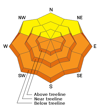
Temps did drop below freezing last night but several days of extreme heat have saturated and weakened the snowpack. As the day heats up the danger for loose wet and wet slab avalanches will again rise to CONSIDERABLE. Thin shallow rocky areas and terrain under cliffs should be avoided. Water is moving through the snowpack, and slopes do not have to be in the sun to be dangerous. Signs of instability include rollerballs, pinwheels, and punchy or sloppy unsupportable snow. Stay off of and out from under steep slopes as they become wet and sloppy.
A very isolated or MODERATE avalanche danger exists on very steep slopes above treeline that face NW-N-NE where stiff slabs overlying weak, faceted snow may still be found. Recent warm temperatures may increase the likelihood of triggering an avalanche on this weak, faceted snow. Shallow snowpack areas with steep convexities and rocky, more radical terrain are where you are most likely to trigger an avalanche.
Low
Moderate
Considerable
High
Extreme
Learn how to read the forecast here
Special Announcements
The Geyser Pass Road is melted down to the dirt up to the parking lot.
The Lower Utah Nordic Alliance is through grooming for the season.
Weather and Snow
24 Hour Snow 0" 72 Hour Snow 0" Base Depth in Gold Basin 54" Wind WNW 15-20 Temp 26F
Temps have finally cooled off as a low-pressure system moves through to the north. Today look for mostly sunny skies, gusty northwesterly winds, and high temps in the mid 30's. We may see a few clouds later today and overnight. A pattern of seasonally warm days and clear nights sets up through the end of the week.
Overnight freezes and daytime high temps mean everything right now. Get current and past 24-hour readings from these real-time weather links.
Wind, temperature, humidity on Pre Laurel Peak (11,700')
SNOTEL site near Geyser Pass Trailhead (9600')
Storm totals and temperatures at the Gold Basin study plot (10,000')
NWS Weather Forecast
Snowpack Discussion
Last night's cooler temps have finally refrozen the snow surface but after several days of extreme heat, the snowpack underneath is well saturated. Sunday's wet slab avalanche was a clear indicator of the current state of instability, and one night's freeze isn't going to take care of the problem. Timing will be everything today. Work slope aspects according to the sun and once the surface crust becomes unsupportable it's time to call it a day. You definitely do not want to be on or underneath steep slopes when they become wet and sloppy.
Weak, sugary, faceted snow still exists near the ground, especially at higher elevations on NW-E aspects. Warm temperatures and percolating water in the snowpack may make these layers more reactive to the weight of a skier or rider. Slopes with steep convexities and rocky, more radical terrain are where you are most likely to trigger an avalanche failing on this weak, faceted snow.
Recent Avalanches
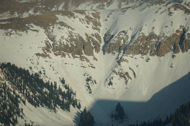
Chris Benson spotted this wet slab avalanche from the air on Sunday evening. Wet slabs have also been observed in the Abajo Mountains.
Ad
Avalanche Problem #1
Wet Snow
Type
Location
Likelihood
Size
Description
Loose Wet Avalanches:
The danger for loose wet avalanches will again quickly rise today as a strong sun melts the thin surface crust. Signs of instability include rollerballs, pinwheels, and "point release" sluffs that fan out and gather more snow as they travel down the slope. Timing is everything today, and you need to get off of steep slopes as they become wet and sloppy.
Wet Slabs:
Record temps and light to no overnight re-freezes have produced wet slab avalanches. This type of wet snow avalanche is harder to predict than loose wet it but can be invariably more dangerous. Wet slabs release when melt water saturates a layer in the snowpack and the over riding slab fails as a cohesive layer. Outward signs of this type of problem are not obvious but sloppy, wet, or punchy snow indicates that the pack is trending towards unstable.
Avalanche Problem #2
Persistent Weak Layer
Type
Location
Likelihood
Size
Description
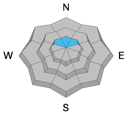
Weak, sugary, faceted snow still exists near the ground, mostly above treeline on NW-N-NE aspects. Warm temperatures and percolating water in the snowpack may make these layers more reactive to the weight of a skier or rider. Thinner snowpack areas around steep convexities, or in rocky, more radical terrain are where you are most likely to trigger an avalanche failing on this weak, faceted snow.
General Announcements
This forecast is from the U.S. Forest Service, which is solely responsible for its content. This forecast describes general avalanche conditions and local variations always occur.