Forecast for the Moab Area Mountains

Eric Trenbeath
Issued by Eric Trenbeath for
Saturday, April 2, 2022
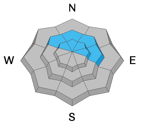
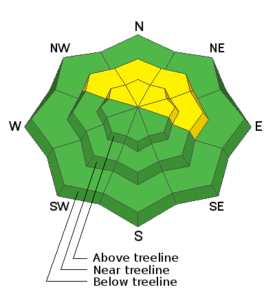
We are finally turning the corner toward generally stable snow conditions and most terrain offers LOW danger. An isolated or MODERATE avalanche danger remains in areas of steep, radical terrain on slopes facing NW-N-NE-E. Near treeline, a low probability/high consequence scenario exists for triggering an avalanche 2'-3' deep on a buried persistent weak layer. Above treeline, isolated, unstable wind slabs exist that could carry you over a cliff or rock band. And finally, as the day heats up, be on the lookout for signs of loose, wet instability such as rollerballs, pinwheels, and sloppy wet snow.
As we turn this corner into greater stability, continue to be mindful of terrain complexities such as steep convexities and blind break overs. Practice safe travel techniques and only expose one person to danger at a time.
Low
Moderate
Considerable
High
Extreme
Learn how to read the forecast here
Special Announcements
We'd like to thank our incredible community for your support of the 2022 Spring Campaign. We raised $75,000 in two weeks to help grow our avalanche forecasting program. Thank You!
Road Conditions: The road is a mix of dirt and mud down low and a few inches of snow up high. It gets sloppier as the days warm up. All wheel drive and good tires are recommended.
Grooming: Trails into Gold Basin were groomed yesterday.
Weather and Snow
6:00 a.m. weather data:
24 Hour Snow 0" 72 Hour Snow 1" Base Depth at Gold Basin 57" Wind SW 15-20 Temp 22F
A few clouds are out this morning, temperatures are well below freezing, and SW winds are ramping up. Today, look for mostly sunny skies, breezy SW winds, and high temps up in the mid 40's. Clouds will develop tonight ahead of a weak system tracking to the north. Sunday will be mostly cloudy and breezy with a very slight chance for snow Sunday night. Dry conditions are on tap for the up coming week.
Snowpack
It was a stellar day in the mountains yesterday with clear skies, negligible wind, and good settled powder on a supportable base. In our travels we found generally stable snow conditions and people were pushing it into areas of large and steep terrain. The best snow exists on upper elevation, northerly aspects just below the main ridge lines. Solar aspects took on a lot of heat and will be crusted over but I think there will be a good chance for finding supportable corn snow on mid elevation S and W facing slopes. NW winds mid-week blew and drifted snow at the highest elevations, and surfaces up there are slightly scoured or crusted. If you are up in these areas, remain on the lookout for unstable drifts on the leeward sides of terrain features such as sub-ridges or gully walls, especially in consequential terrain where a triggered wind slab could carry you over a cliff.
The Jan-Feb persistent weak layer is still present though stability tests are consistently showing the layer to be non-reactive. I feel safe in saying that we have moved into a low probability, but nevertheless, high consequence scenario. The weakest snow exists right around treeline, and steep, complex, featured terrain in this zone is where you are most likely to find trouble.
Snow and Weather Links
Gold Basin SNOTEL site (10,000')
Storm Totals in Gold Basin
Wind Station on Pre Laurel Peak (11,700')
Ad
Avalanche Problem #1
Normal Caution
Type
Location
Likelihood
Size
Description
Most terrain offers generally low danger but the La Sals are a big "little" mountain range comprised of large, steep, and radical terrain. It's also been an unusual winter with persistent weak layer problems lingering late into the season. As you start to set your sights on larger objectives keep the following in mind:
  • A persistent weak layer of faceted snow still exists on northerly aspects, with the weakest snow found right around treeline. Stability tests this week have shown that this weak layer has gained strength and is largely non-reactive however, it could still pose a threat in areas of extreme terrain right around treeline. Minimize your risk by avoiding this type of terrain.
  • Isolated wind slabs exist in upper elevation, wind exposed terrain. Though likely small, a triggered wind slab could carry you over a rock band or cliff. Remain on the lookout for unstable areas of wind drifted snow, especially in consequential terrain.
  • As the day heats up, be alert to signs of loose, wet instability such as rollerballs and pinwheels on sun exposed slopes, and get off of steep slopes if they become wet and sloppy.
Additional Information
General Announcements
Who's up for some free avalanche training? Get a refresher, become better prepared for an upcoming avalanche class, or just boost your skills. Go to https://learn.kbyg.org/ and scroll down to Step 2 for a series of interactive online avalanche courses produced by the UAC.
This forecast is from the U.S.D.A. Forest Service, which is solely responsible for its content. This forecast describes general avalanche conditions and local variations always occur.