Forecast for the Moab Area Mountains

Eric Trenbeath
Issued by Eric Trenbeath for
Wednesday, April 13, 2022
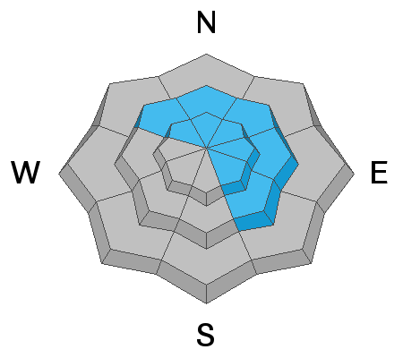
A MODERATE avalanche danger exists on steep slopes that have recent deposits of wind drifted snow. Fresh, unstable drifts are most likely to be found on leeward slopes facing NW through N through SE. Look for fresh drifts on the leeward sides of ridge crests and terrain features such as gully walls and sub ridges. Triggered wind slabs may run far and fast on slick surfaces underneath. You may also encounter some fast running, loose snow sluffs. Utilize slope cuts and test slopes to see how the snow is behaving before committing to steep terrain.
Low
Moderate
Considerable
High
Extreme
Learn how to read the forecast here
Special Announcements
This weekend will see the end of regular avalanche forecasts.
Road Conditions: Expect a few inches of new snow on bare dirt.
Grooming: Done for the season.
Weather and Snow
7:00 a.m. weather data:
24 Hour Snow 2" 72 Hour Snow 8" Base Depth at Gold Basin 54" Wind WNW 10-15 Temp 8F
Brrr! Welcome back to the dead of winter! Yesterday's storm system brought 8" of new snow to the mountains and moderate winds during the day were remarkably well behaved. A few clouds are hanging over the mountains this morning, but today we should see mostly sunny skies with increasing westerly winds that will blow in the 15-25 mph range with possible gusts to 40. High temps will be in the low 20's but wind chill values will make it fell much colder. Thursday will see a few clouds, continued breezy conditions, and temps about 10 degrees warmer. The pattern to the north remains unsettled through the week but we'll stay dry and windy with slowly warming temperatures.
Snowpack
I don't have any reports from the backcountry but I'll be headed up today to have a look around. I'm expecting to find recent wind drifts up to a foot deep on leeward slopes, with continued loading today by westerly winds. I suspect they may be less sensitive today, but potentially unstable drifts are sitting on top of a variety of slick, hard surfaces, and if triggered, may run faster and farther than you expect. Utilize slope cuts and test slopes to see how the snow is behaving before you just jump right in. If you see cracking or blocks of snow breaking off, you've found an unstable wind slab. Prior to this storm, spring conditions were in effect with stout melt freeze crusts on sun exposed slopes, and areas of wind blasted, dryish, transitional snow still hanging around on upper elevation, northerly aspects. Many south facing slopes were melted down to the rocks, and existing lines are getting quite thin on these aspects.
Gold Basin SNOTEL site (10,000')
Storm Totals in Gold Basin
Wind Station on Pre Laurel Peak (11,700')
Ad
Avalanche Problem #1
Wind Drifted Snow
Type
Location
Likelihood
Size
Description
Unstable areas of recently deposited wind drifted snow are your primary concern today. Fresh drifts are most likely to be found on leeward slopes facing NW through N through SE. Look for fresh drifts on the leeward sides of ridge crests and terrain features such as gully walls and sub ridges. Recent drifts are recognizable by their smooth, rounded appearance, and cracking is a sign of instability. Though mostly shallow and manageable, triggered wind slabs may run far and fast on slick surfaces underneath. Utilize slope cuts and test slopes to see how the snow is behaving before you just jump right in.
General Announcements
Who's up for some free avalanche training? Get a refresher, become better prepared for an upcoming avalanche class, or just boost your skills. Go to https://learn.kbyg.org/ and scroll down to Step 2 for a series of interactive online avalanche courses produced by the UAC.
This forecast is from the U.S.D.A. Forest Service, which is solely responsible for its content. This forecast describes general avalanche conditions and local variations always occur.