Forecast for the Moab Area Mountains

Eric Trenbeath
Issued by Eric Trenbeath for
Wednesday, March 6, 2024
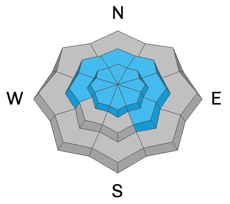
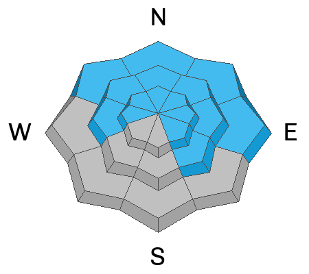
The avalanche danger is MODERATE and human triggered avalanches involving slabs of wind drifted snow up to 2' deep remain possible, primarily on slopes facing NW-N-NE-E. In these same areas, deep drifts have added stress to a buried persistent weak layer increasing the likelihood for a much deeper avalanche.
The danger decreases as you wrap around to the southern half of the compass, but isolated, shallower drifts may still be found, especially on slopes facing W and SE.
Wind slabs are recognizable by their smooth, rounded appearance, and they may sound or feel hollow underneath. Cracking is a sign of instability.
Low
Moderate
Considerable
High
Extreme
Learn how to read the forecast here
Special Announcements
We are seeking a passionate individual to join us as Executive Director of the nonprofit Utah Avalanche Center. Click here for more information.
Road Conditions: The Geyser Pass Road to the winter trailhead is plowed. The surface is snowpacked and AWD with good tires recommended.
Grooming: Trails will start seeing some attention today.
Weather and Snow
6:00 a.m. Snow and Weather Data
24 Hour Snow 0" 72 Hour Snow 0" Season Total Snow 143" Depth at Gold Basin 53"
Winds on Pre-Laurel Peak: SW 15-25 G 30 Temp 24° Percent of Normal: 99%

Weather
Winds from the SW were on the increase again overnight as a low pressure system tracks by to the north. Today looks like one of those days where if you don't like the weather, wait 5 minutes. We should see mostly sunny skies with some developing clouds and a very slight chance for some flurries. We'll see overall light to moderate SW winds with some higher speeds along ridge tops. High temps at 10,000' will be near 30 degrees. A low pressure system currently off the Pacific coast moves inland tonight. This system is taking a southerly track but we should pick up a few inches of snow on Thursday. High pressure and warming temperatures settle in for the weekend.
General Conditions
In our travels on Monday, Dave and I concluded that overall conditions are one star but that's still a huge improvement. 8" of new snow Saturday night was wildly blown and unevenly distributed and most open terrain has some degree of wind affect. Sheltered locations offer much better conditions. We continued to observe active blowing and drifting of the most recent snow, and we found wind slabs formed over the past couple of days to be widely distributed across the landscape. They varied in depth from 6"-24" with the deepest drifts found on north and easterly aspects. On southerly aspects, drifts are shallow and more isolated, often existing next to scoured surfaces. We did not observe much cracking, but we experienced several collapses indicating that slabs of wind drifted snow remained sensitive to the weight of a skier or rider. Wind slabs are gaining strength and will be much harder to trigger today, but I'd continue to remain wary of steep, wind drifted slopes.
On steep, northerly aspects, deep drifts have added stress to a persistent weak layer (PWL) of faceted snow near the base of the snowpack. This has increased the likelihood for triggering a deeper and more dangerous avalanche. We are uncertain to what degree this load has affected the PWL, and we've been wrestling with how to quantify the likelihood of triggering a deep avalanche for some time now. For more details on that see my recent blog post. The bottom line is that Dave and I are continuing to avoid big, steep, northerly facing slopes.
Snowpack and Weather Data
Gold Basin Storm Stake (10,000')
Gold Basin SNOTEL site (10,000')
SNOTEL site near Geyser Pass Winter Trailhead (9600')
Wind Station on Pre-Laurel Peak (11,400')
NWS forecast for the La Sal Mountains.
Ad
Avalanche Problem #1
Wind Drifted Snow
Type
Location
Likelihood
Size
Description
Strong winds from the south and west have blown and drifted snow at all elevations. The problem is most pronounced on leeward-facing slopes near treeline and above where drifted snow has formed slabs 12-24 inches deep. Slopes that face NW-N-E are the bulls-eye location for this problem. Wind slabs will be more stubborn to trigger today meaning that you may be further down slope before they release. Cracking, collapsing, and hollow sounds are obvious clues that you have stepped onto an unstable drift.
It is possible to encounter recent drifts on windward aspects as well. Strong winds often swirl and change direction in the mountains and can deposit snow on any aspect. On slopes that face W-S-SE, this problem will be more isolated. Many southerly facing slopes may be scoured, but look for fresh drifts around terrain features that facilitate loading such as gully walls, under cliff bands, along sub-ridges, beneath convexities, and in scoops, saddles, and sinks.
Avalanche Problem #2
Persistent Weak Layer
Type
Location
Likelihood
Size
Description
For some time, we have remained in a low likelihood, high consequence scenario for avalanches failing down to the persistent weak layer (PWL). Deep wind-drifts have formed on the same slopes that harbor weak layers of faceted snow, adding stress to the layer and increasing the likelihood of triggering a deep and very dangerous avalanche. Triggering an avalanche in wind-drifted snow remains your primary concern, but any avalanche triggered in wind-drifted snow has the potential to step down to the deeply buried PWL. Give the buried weak layer some time to adjust to the new load and look for safe and fun riding in sheltered, low-angle terrain.
Additional Information
Want some more insight into the La Sal Mountains as well as the communal impacts of a tragic avalanche? Check out the latest UAC podcast with forecaster Eric Trenbeath where he discusses the range, it's often treacherous snowpack, and how the devastating avalanche in February, 1992, affected the Moab community.
Our avalanche beacon checker sign and beacon training park are up and running. A huge thanks to Talking Mountain Yurts for sponsoring those this season!
Sign up for forecast region-specific text message alerts. You will receive messages about changing avalanche conditions, watches, warnings and road plowing closures.
Follow us on Instagram @utavy_moab
General Announcements
This forecast is from the U.S.D.A. Forest Service, which is solely responsible for its content. This forecast describes general avalanche conditions and local variations always occur.