Join us at our 2nd Annual Blizzard Ball

Forecast for the Moab Area Mountains

Eric Trenbeath
Issued by Eric Trenbeath on
Saturday morning, March 6, 2021
The avalanche danger remains MODERATE today with several potential problems.
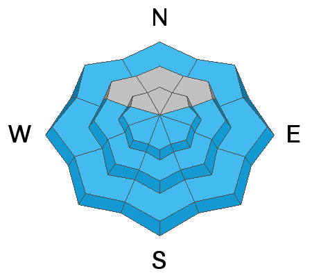
  • Persistent Weak Layer Deep and dangerous human-triggered avalanches failing on a layer of sugary, faceted snow remain possible primarily on steep slopes near and above treeline that face NW-N-E-SE. This is becoming a low probability/high consequence situation. Shallow areas along slope margins and near rock outcroppings or sparse trees are potential trigger points.
  • Wet Snow As the day heats up sun-exposed slopes will become wet, sloppy, and susceptible to avalanches. Signs of instability include roller balls, pinwheels, and small point release sluffs. Stay off of and out from under steep slopes when these signs are present.
  • Wind Drifts Isolated, unstable wind drifts may still exist on the leeward signs of ridge crests and terrain features in upper elevation, wind exposed terrain. Avoid steep wind drifted slopes.
Low
Moderate
Considerable
High
Extreme
Learn how to read the forecast here
Special Announcements
The Geyser Pass Road was plowed and widened on Wednesday. A couple inches of snow fell on Thursday and all-wheel drive with good tires is recommended. Beware of soft shoulders.
The Lower Utah Nordic Alliance (LUNA) groomed and set classic track into Gold Basin on Thursday. Traffic on Friday roughed up the surface.
Weather and Snow
24 Hour Snow 0" 72 Hour Snow 3" Base Depth in Gold Basin 48" Wind S 25-30 G38 Temp 29F
Under clear skies, southerly winds began to increase around midnight where they've averaged around 30 mph for the last six hours. Overnight low temps dipped into the 20's above 10,000' but low elevations did not see much of a freeze and it's already a warm 35F at the Geyser Pass Trailhead. Today will be sunny, warm, and breezy with continued moderate ridgetop southerly winds and high temps near 40F, Sunday and Monday will be even warmer with temps soaring into the mid 40's. The mid-month Pacific trough we've been placing our hopes on for so long is looking less promising by the day as models continue to struggle for a solution. For now, look for unsettled weather to begin on Wednesday.
Wind, temperature, humidity on Pre Laurel Peak (11,700')
Snotel site near Geyser Pass Trailhead (9600')
Storm totals at the Gold Basin study plot (10,000')
Snowpack Discussion
A few inches of new snow on Thursday freshened up conditions but the sun was out in full force yesterday and most sun-exposed slopes will be crusted over this morning. In short, spring-like conditions are in effect and the snow during the day will be a mixed bag of crusts and glop with dry snow on shady aspects. Warm temperatures have helped to strengthen the snowpack and we are moving toward a low probability/high consequence situation for deep and dangerous avalanches. Weak, faceted snow can still be found on most aspects and stiff, hard slabs 1'-3' thick exist over this weak layer on slopes facing primarily NW-N-E-SE. Shallow areas, along slope margins and near rock outcroppings or sparse trees remain likely trigger points.
Ad
Avalanche Problem #1
Persistent Weak Layer
Type
Location
Likelihood
Size
Description
Poor snowpack structure exists with consolidated slabs resting on buried persistent weak layers of loose, sugary, faceted snow on many aspects. The most dangerous areas are on slopes near and above treeline that face NW-N-SE where wind drifted snow has created slabs 1'-3' deep on top of these buried weak layers. These avalanches are becoming harder to trigger but once released, they will be large and destructive. Likely trigger points include shallower areas along slope margins, around sparse trees or rock outcroppings, or on repeat running slide paths.
Avalanche Problem #2
Wet Snow
Type
Location
Likelihood
Size
Description
We will likely see some shallow, loose wet activity today as the day heats up. Look for signs of instability such as roller balls and pinwheels, and get off of and out from under steep slopes if they become wet and sloppy.
Avalanche Problem #3
Wind Drifted Snow
Type
Location
Likelihood
Size
Description
A few inches of new snow combined with wind during the week has created shallow deposits of wind drifted snow upper elevations. Look for fresh drifts on the leeward sides of ridge crests and terrain features like sub-ridges and gully walls. On steep, northerly aspects, wind drifted snow has added additional stress to buried persistent weak layers so it isn't merely a question of identifying and testing for wind slab instability. The bottom line is that steep, wind loaded, northerly-facing terrain is where you are most likely to trigger a deep and dangerous avalanche.
General Announcements
This forecast is from the U.S. Forest Service, which is solely responsible for its content. This forecast describes general avalanche conditions and local variations always occur.