Forecast for the Moab Area Mountains

Dave Garcia
Issued by Dave Garcia for
Wednesday, March 30, 2022
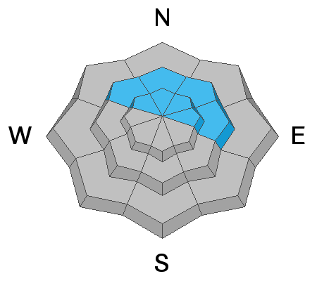
On steep terrain near and above treeline on slopes that face NW-N-E there is a MODERATE danger for triggering an avalanche on a buried persistent weak layer of faceted snow. Eight inches of new snow and strong, shifting winds have created a MODERATE danger for triggering an avalanche in wind drifted snow on all aspects above treeline. On slopes that face W-S-SE near treeline and below you can enjoy eight inches of new snow and a LOW avalanche danger.
Low
Moderate
Considerable
High
Extreme
Learn how to read the forecast here
Special Announcements
Please help support avalanche forecasting throughout Utah. Donate to the Spring Campaign to help raise the funds to support the forecasting you rely on.
Road Conditions: The road is a mix of dirt and mud down low and a few inches of snow up high. It gets sloppier as the days warm up. All wheel drive and good tires are recommended.
Grooming: Trails have not been groomed.
Weather and Snow
6:00 a.m. weather data:
24 Hour Snow 3" 72 Hour Snow 8" Base Depth at Gold Basin 57" Wind NW 20-25 Temp 25F
We will see lingering snow showers this morning that could add another trace to an inch of snow. Look for partial clearing this afternoon, and maybe even a little bit of sunshine. High temps will be in the upper 20's. Winds are out of the NW this morning, and will shift to the N as the day progresses. Wind speeds will be around 15 mph in valley bottoms and 25-30 mph on the ridge lines. A small system will affect our area Thursday night, but it doesn't look like much snow at this time.
Snowpack
Three inches of snow overnight brings us up to a total of 8 inches since Monday night. The initial five inches came in warm and moist, and bonded well to the old snow surface. I'm expecting the most recent snow to be similar. Overnight snowfall came with strong winds from the NNW, be on the lookout for fresh drifts of wind blown snow above treeline. We still have some concern for the buried persistent weak layer of facets that exists on slopes that face NW-N-NE-E. It is still possible to trigger an avalanche 2-3 deep on this weak layer.
Snow and Weather Links
Gold Basin SNOTEL site (10,000')
Storm Totals in Gold Basin
Wind Station on Pre Laurel Peak (11,700')
Recent Avalanches
In my travels yesterday I came across some old wet loose debris on a variety of aspects from the weekend's heat wave.
Ad
Avalanche Problem #1
Persistent Weak Layer
Type
Location
Likelihood
Size
Description
A persistent weak layer of faceted snow still exists near treeline and above on NW-N-NE-E aspects beneath a slab that is 2'-3' thick. Time and recent warm temperatures have helped this layer to gain strength. Yesterday I found a strong, stiff slab overlying the weak layer. The buried weak layer did not react to stability testing yesterday, but we're not entirely out of the woods yet. The weekend heat wave was an unusual and significant event and I'd like to see a few more snowpits that show strong snow and no failures. For now, you should expect some lingering instabilities involving this buried persistent weak layer. I am most suspect of sparsely treed areas right around treeline. Other spots where you could possibly trigger this layer include shallow snowpack areas, near rock outcroppings, and gully walls.
For more details check out my observation from yesterday's field work.
Avalanche Problem #2
Wind Drifted Snow
Type
Location
Likelihood
Size
Description
Be on the lookout for recently deposited wind slabs on all aspects above treeline. The new snow came in with strong winds from the South, which have now shifted to the North and continue to blow. Expect to find fresh drifts right below ridge lines. This problem should be easily managed today. Wind drifted snow will have a smooth, rounded appearance and cracking is a sign of instability.
Additional Information
A snowpit from a NE aspect at 11,060 feet shows the buried weak layer gaining strength.
General Announcements
Who's up for some free avalanche training? Get a refresher, become better prepared for an upcoming avalanche class, or just boost your skills. Go to https://learn.kbyg.org/ and scroll down to Step 2 for a series of interactive online avalanche courses produced by the UAC.
This forecast is from the U.S.D.A. Forest Service, which is solely responsible for its content. This forecast describes general avalanche conditions and local variations always occur.