Forecast for the Moab Area Mountains

Eric Trenbeath
Issued by Eric Trenbeath on
Saturday morning, March 29, 2025
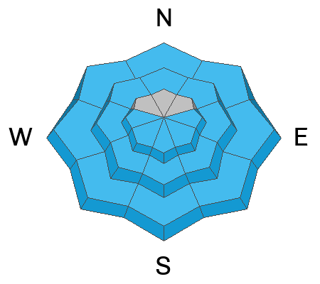
Although the danger has decreased significantly since mid-week, today we will again see a MODERATE danger for loose wet, and wet slab avalanches on all aspects and elevations with the exception of high elevation, northerly aspects. Get in and out early. Stay off of and out from under steep slopes if they start to become wet and sloppy.
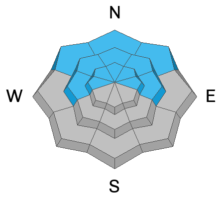
A MODERATE danger remains for human triggered avalanches failing on a buried persistent weak layer. This is a low probability, high consequence scenario. You are mostly likely to encounter this problem on steep, northerly aspects right around treeline with isolated areas above. Warm temperatures this past week have greatly decreased the likelihood at lower elevations and on westerly aspects and although not out of the question, I suspect we have turned the corner in these areas.
Low
Moderate
Considerable
High
Extreme
Learn how to read the forecast here
Special Announcements
Our Spring Campaign is in full swing, and there are two great ways to support forecasting, awareness, and education across Utah: Donate to our Spring Campaign, or Bid on items in our Spring Auction. Every dollar donated helps keep the backcountry community on top.
Construction continues on the Loop Road Mon-Fri. It will be closed near Pack Creek from 8:30-5:30.
Geyser Pass Road: The road is melted down to the dirt.
Grooming Conditions: Grooming is done for the season.
Weather and Snow
6 A.M. Snow and Weather Data
24 Hour Snow: 0" 72 Hour Snow: 0" Season Total Snow: 121" Depth at Gold Basin: 43"
Winds on Pre-Laurel Peak: N/A Temp: 30° F
Weather
A shortwave trough will exit the region this morning leaving mostly sunny skies in it's wake. A second trough passes by to the north this afternoon bringing more clouds and a chance for snow showers. Look for continued breezy southwest winds, and high temperatures near 40°F at 10,000'. Skies will be mostly cloudy tonight with temperatures dropping down into the low 20's or high teens. Sunday looks partly sunny with a slight chance for afternoon showers. Unsettled weather is on tap for the upcoming week.
General Conditions
A light refreeze occurred overnight for the first time in several days. This should make for some supportable conditions out there this morning but the window will be short. As the day heats up, you will again need to be alert to the threat of wet avalanche activity.
Overall, the weather this past week has not been good for skiing and riding conditions. Dry surface snow is all but non-existent, and the lack of overnight freezes has prevented a corn cycle from happening. So it goes. The good news is that warm temperatures and percolating melt water are helping to consolidate the snowpack which will work toward curing our persistent weak layer problem. At lower elevations the process is well under way but buried cold, dry facets still remain on northerly aspects near and above treeline and this is where you are most likely to find trouble.
Snowpack and Weather Data
Gold Basin SNOTEL site (10,000')
SNOTEL site near Geyser Pass Winter Trailhead (9600')
Wind Station on Pre-Laurel Peak (11,400')
NWS forecast for the La Sal Mountains.
Recent Avalanches
Numerous loose wet avalanches have occurred over the past several days.
See the complete avalanche database here.
Ad
Avalanche Problem #1
Wet Snow
Type
Location
Likelihood
Size
Description
A very light overnight refreeze and sunny skies this morning mean we will again have to pay attention to signs of wet snow instability. Although I suspect the cycle has largely played out, loose wet avalanches are possible on all aspects and elevations with the exception of high elevation northerlies. Signs of instability include rollerballs, pinwheels, and sloppy wet snow. Stay off of and out from under steep slopes when these signs are present.
Although harder to predict, wet slab avalanches are also possible. On south through westerly aspects, melt water can pool on buried crusts and faceted layers nearer to the surface increasing the likelihood for wet slab avalanches. There is a higher degree of uncertainty regarding the faceted weak layers on northerlies. Faceted snow packs can be somewhat unpredictable during rapid warming events. The conservative choice is to let the heat wave play out and wait for a solid refreeze.
Avalanche Problem #2
Persistent Weak Layer
Type
Location
Likelihood
Size
Description
Warm temperatures and percolating melt water are working to consolidate and strengthen the snowpack but it's still very much in transition. The likelihood for triggering an avalanche on a PWL has decreased significantly, particularly on west, and on lower elevation northerly aspects but I'd really like to see a few nights with a solid refreeze before I let it go. Layers of cold, dry faceted snow still remain on steep, northerly aspects near treeline, and in some areas above. Likely trigger points are steep convexities, thin slab margins, and shallow rocky areas. If you are biting off pieces of avalanche terrain, choose smooth planar slopes with clean run-out zones.
Additional Information
Check out the latest UAC podcast with forecaster Brett "Kowboy" Kobernick where he discusses faceted persistent weak layers and how "nobody is immune from getting killed in an avalanche."
Sign up for text alerts to get the most up to date information about changing conditions, road plowing, special avalanche announcements.
Follow us on Instagram @utavy_moab
General Announcements
This forecast is from the U.S.D.A. Forest Service, which is solely responsible for its content. This forecast describes general avalanche conditions and local variations always occur.