Join us at our 2nd Annual Blizzard Ball

Forecast for the Moab Area Mountains

Eric Trenbeath
Issued by Eric Trenbeath on
Sunday morning, March 27, 2022
Near record daytime temperatures, and two nights without a re-freeze have created dangerous conditions in the backcountry.
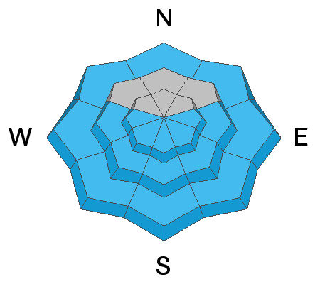
The avalanche danger will quickly rise to CONSIDERABLE on steep, sun exposed slopes. Natural and human triggered loose, wet avalanches are likely and wet slab releases are possible.
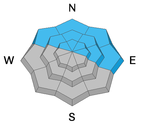
On slopes facing the north half of the compass, melt water percolating down to the buried persistent weak layer may increase the likelihood for human triggered avalanches 2'-3' deep. A fair amount of uncertainty surrounds this scenario but current conditions make this kind of terrain high risk and low reward. Avalanche terrain should be avoided today.
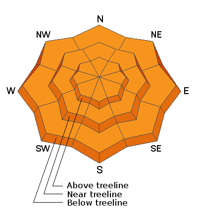
Low
Moderate
Considerable
High
Extreme
Learn how to read the forecast here
Special Announcements
Please help support avalanche forecasting throughout Utah. Donate to the Spring Campaign to help raise the funds to support the forecasting you rely on.
Road Conditions: The road is a mix of dirt, mud, and patches of packed snow. It gets sloppier as the days warm up. All wheel drive and good tires are recommended.
Grooming: Trails have not been groomed.
Weather and Snow
6:00 a.m. weather data:
24 Hour Snow 0" 72 Hour Snow 0" Base Depth at Gold Basin 55" Wind S 10-20 G25 Temp 36F
Temperatures again did not get below freezing last night and they're basically where they were yesterday at this time ranging from the mid 40's at Geyser Pass Trailhead to the mid 30's up high. The heat wave continues today as the ridge axis moves overhead. High temps will again rise into the 50's under mostly sunny skies. Tonight will be slightly cooler but still not cool enough for a good freeze, and Monday will again see temps near 50F. By Monday afternoon we should start to see some clouds ahead of a low pressure system making its way inland from the coast of Southern California. We should see some snow on Tuesday.
Snowpack
Another night without a refreeze and record breaking temps on tap for today are not a good set up for snow and avalanche conditions. Most surfaces will be punchy and unsupportable this morning, and they will quickly become wet and sloppy as the day heats up. As temps soar, loose, wet avalanches will become likely on steep, sun exposed slopes, especially in rocky or cliffy areas, and we may even see some wet slab releases.
On slopes facing NW-N-NE-E, we still have a persistent weak layer of sugary faceted snow that formed during the Jan-Feb dry period. The weakest snow exists right around treeline on slopes with a northeasterly component. As melt water percolates down through the snowpack, avalanches failing on this weak layer may become increasingly more likely. A fair amount of uncertainty surrounds this scenario but current conditions make this kind of terrain high risk and low reward.
Snow and Weather Links
Gold Basin SNOTEL site (10,000')
Storm Totals in Gold Basin
Wind Station on Pre Laurel Peak (11,700')
Recent Avalanches
In my travels on Friday, I observed numerous, loose wet avalanches, primarily at mid elevations on steep slopes facing E-S-W.
Ad
Avalanche Problem #1
Wet Snow
Type
Location
Likelihood
Size
Description
With a strong sun and dramatically warm temperatures the avalanche danger will quickly rise on sun exposed slopes today. Both loose wet, and wet slab avalanches are possible. Stay off of and out from under steep slopes that are wet and sloppy. There's not much more to say about it. It didn't freeze last night. It's going to get sloppy quick. Stay off of it.
Avalanche Problem #2
Persistent Weak Layer
Type
Location
Likelihood
Size
Description
A persistent weak layer of dry, sugary faceted snow still exists on NW-N-NE-E aspects beneath a slab that is 2'-3' thick. The weakest snow exists right around treeline and this is the most likely zone for triggering an avalanche. As more melt water percolates down through the snowpack, avalanches failing on this weak layer may become increasingly more likely.
General Announcements
Who's up for some free avalanche training? Get a refresher, become better prepared for an upcoming avalanche class, or just boost your skills. Go to https://learn.kbyg.org/ and scroll down to Step 2 for a series of interactive online avalanche courses produced by the UAC.
This forecast is from the U.S.D.A. Forest Service, which is solely responsible for its content. This forecast describes general avalanche conditions and local variations always occur.