Join us at our 2nd Annual Blizzard Ball

Forecast for the Moab Area Mountains

Eric Trenbeath
Issued by Eric Trenbeath on
Friday morning, March 26, 2021
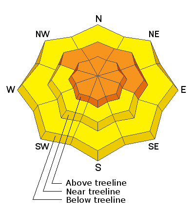
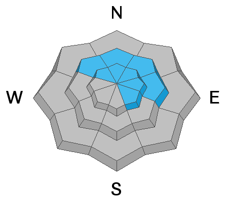
Recent and wind drifted snow has caused a rise in avalanche danger. The avalanche danger is CONSIDERABLE on steep, wind drifted slopes near and above treeline that face NW-N-E and human-triggered avalanches are likely in these areas. All other terrain has a MODERATE avalanche danger and human-triggered, soft slab avalanches involving the new snow are possible on slopes steeper than about 35 degrees. And finally, the recent snowload may increase the likelihood for triggering a deep and dangerous avalanche on a buried persistent weak layer. The danger for this type of avalanche is MODERATE on steep slopes facing NW-N-E-SE. Thinner snowpack areas and slopes made up of steep, rocky terrain are the most likely trigger points.
Low
Moderate
Considerable
High
Extreme
Learn how to read the forecast here
Special Announcements
The 2021 Spring Awareness Campaign is underway. Help us save lives through avalanche forecasts and education. Consider making a donation to show your support HERE.
Over the last couple of days, two different fatal avalanche accidents have occurred in CA and CO. Our deepest condolences to the friends and families of these victims.
The Geyser Pass Road has not been plowed. Expect several inches of new snow on a dirt surface. Four-wheel-drive required.
The Lower Utah Nordic Alliance (LUNA) has plans to groom today.
Weather and Snow
24 Hour Snow 11" 72 Hour Snow 18" Base Depth in Gold Basin 78" Wind SW 10-15 G28 Temp 18F
Snowfall kicked in around 3:00 p.m. yesterday and mountain stations are reporting 10" in Gold Basin and 5" at the Geyser Pass Trailhead. Expect cloudy skies and lingering showers today as a low-pressure system moves through the 4 Corners. 2"-4" of additional snow is possible. SW winds will average 5-10 mph with gusts to 20 along ridge tops. High temps will be in the mid to upper 20's. Winds shift to the NW tonight as the system moves on bringing dry and warmer conditions for the extended period.
Wind, temperature, humidity on Pre Laurel Peak (11,700')
SNOTEL site near Geyser Pass Trailhead (9600')
Storm totals at the Gold Basin study plot (10,000')
Snowpack Discussion
18" of new snow has stacked up over the past few days which is certainly enough to create avalanche concerns. With 11" coming in over the past 24 hours be on the lookout for new snow instabilities on steep slopes on all aspects where the new snow may have formed a cohesive, soft slab. Look for signs of instability such as cracking in the snow surface. In addition, southerly winds yesterday and overnight have loaded northerly aspects near and above treeline. Look for fresh, unstable drifts up to 2' deep on the leeward sides of ridge crests and terrain features and avoid steep, wind drifted slopes.
Weak, faceted snow still exists near the ground and this new load may be enough to increase the likelihood of triggering an avalanche on this buried, persistent weak layer. Deep and dangerous avalanches failing on weak facets are still being triggered in neighboring Colorado. You are most likely to trigger one of these avalanches in areas of steep, rocky terrain that has a thinner snowpack.
Ad
Avalanche Problem #1
Wind Drifted Snow
Type
Location
Likelihood
Size
Description
18" of accumulated snow combined with moderate southerly winds has resulted in the formation of fresh deposits of wind drifted snow on northerly aspects near and above treeline. Unstable drifts up to 2' deep are likely to be found out there today. Fresh drifts are recognizable by their smooth, rounded appearance and cracking is a sign of instability. Look for recent drifting on the leeward sides of ridge crests and terrain features and avoid steep, wind drifted slopes.
Avalanche Problem #2
New Snow
Type
Location
Likelihood
Size
Description
Human triggered avalanches within the new snow will be possible on steep slopes on all aspects today. These may come in the form of cohesive soft slabs or loose snow sluffs. If you see cracking in the snow surface, or blocks between your skis you will know the storm snow is forming a slab. Avoid steep slopes with more than about 8"-10" of snow if these signs are present. Loose snow sluffing may also be a concern. Stay out from under steep, high faces today.
Avalanche Problem #3
Persistent Weak Layer
Type
Location
Likelihood
Size
Description
The new snowload may be enough to increase the likelihood of triggering a deep and danerous avalanche on a buried persistent weak layer of sugary faceted snow that exists deep in the snowpack. Areas of rocky, more extreme terrain, where the snowpack is shallow and weak are the most likely areas to find trouble. New and wind drifted snow should present enough of a hazard to keep you out of these areas today, but be advised that deeper and more dangerous avalanches remain possible.
General Announcements
This forecast is from the U.S. Forest Service, which is solely responsible for its content. This forecast describes general avalanche conditions and local variations always occur.