Join us at our 2nd Annual Blizzard Ball

Forecast for the Moab Area Mountains

Issued by Chris Benson on
Wednesday morning, March 24, 2021
Recent snow and wind has increased the danger on all aspects near and above treeline to MODERATE, with human-triggered avalanches possible. Modest new snow amounts and moderate-strong NNE winds overnight have made it possible to trigger a small avalanche that could step-down and produce a deep and dangerous avalanche on a buried persistent weak layer near the ground. The most dangerous areas exist near and above treeline on steep slopes that face NW-N-E-SE. Thinner snowpack areas and slopes made up of steep, rocky terrain are the most likely trigger points. Suspect slopes that have a smooth rounded appearance or that sound or feel hollow underneath. Most other terrain has generally LOW danger.
Low
Moderate
Considerable
High
Extreme
Learn how to read the forecast here
Special Announcements
The 2021 Spring Awareness Campaign is underway. Help us save lives through avalanche forecasts and education. Consider making a donation to show your support HERE.
Over the last couple of days, two different fatal avalanche accidents have occurred in CA and CO. Our deepest condolences to the friends and families of these victims.
The Geyser Pass Road has been plowed and is down to the dirt in most areas. Patches of ice and snow exist and it turns muddy as the day heats up. All-wheel-drive recommended.
The Lower Utah Nordic Alliance (LUNA) groomed into Gold Basin on Friday.
Weather and Snow
24 Hour Snow 5" 72 Hour Snow 5" Base Depth in Gold Basin 68" Wind NNE 20-30 G 45 Temp 18F
Look for scattered snow showers today with another 1-2" of snow possible throughout the day as the center of a low-pressure system passes through the AZ/NM border. Yesterday's storm resulted in 5" of new snow (0.4" SWE) with NNE winds, 20-35 mph that picked up last night and will continue until mid-day when they will diminish and shift towards the NW. Clearing skies by late-afternoon and high temps at 10,000' will be around 33F. A transient ridge will then push this system east and yet another system enters our area mid-day tomorrow. This system will favor the southern mountains and looks likely to bring a good-dose of moisture with conservative estimates of 1-foot of snow to the high country of the 4 Corners Region by the end of Friday.
Wind, temperature, humidity on Pre Laurel Peak (11,700')
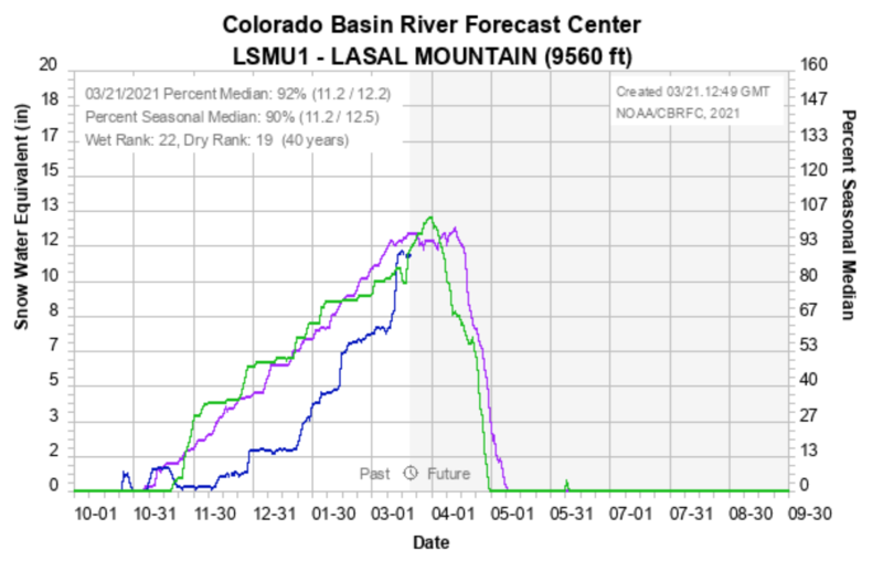
SNOTEL site near Geyser Pass Trailhead (9600')
Storm totals at the Gold Basin study plot (10,000')
Snowpack Discussion
3-5" of new snow yesterday with moderate NNE winds overnight has likely resulted in numerous shallow wind slabs in wind-exposed terrain at higher elevations. Yesterday in more wind-sheltered areas, I observed a variety of surfaces that the new snow has fallen-on. On southerly aspects, I encountered a supportive-crust and on well-shaded, northerly aspects, I observed soft snow containing some graupel in the uppermost layers. A couple of shovel-tilt-tests informed me that some of these layers are not bonding very well and it will be interesting to see how new snow and/or wind-drifted snow will bond with these surfaces.
Deeper in the snowpack, time and warm temperatures have helped the snowpack adjust to the large snow load we received on March 13th, but it's still possible to trigger a deep and dangerous avalanche on a buried persistent weak layer of sugary, faceted snow near the ground. At lower elevations, these weak layers have consolidated and in places are 1-finger in hardness (strong). At higher elevations, these facets are often thicker, and only fist-hardness (weak).
Recent Avalanches
It's now been over a week since the last avalanche cycle. Getting out and about we've observed numerous slides that ran on northerly aspects near and above treeline that failed on a buried persistent weak layer of sugary, faceted snow near the ground. Most of these avalanches occurred in rocky, shallower snowpack areas or in repeat-running slide paths.
Ad
Avalanche Problem #1
Persistent Weak Layer
Type
Location
Likelihood
Size
Description
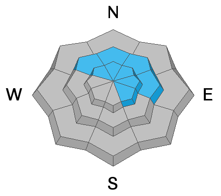
Most of the avalanches from the last cycle (March 14th) stepped-down to a layer of weak, faceted snow near the ground, and human triggered avalanches remain possible on similar slopes that have not avalanched. New snow and wind have increased the chances of avalanches today. The greatest concern is on wind loaded slopes that face NW-N-E-SE near and above treeline. Yesterday on a NE aspect near treeline, I found large (2-3mm) angular depth hoar still present at the bottom of the snowpack. 3-5 feet of dense snow is resting on top of these weak layers, and although it is difficult to trigger an avalanche failing on these weak layers, if you find the wrong spot, the possibility still exists to trigger a large and destructive avalanche. I did a couple of extended column tests, which did not produce any results, however, as you can see in a propagation saw test below, we still have a deep, persistent slab problem. Suspect areas and likely trigger points include: thin snowpack areas consisting of steep, rocky terrain, thinner snowpack areas along slope margins, and near rock outcroppings or trees. Today, reduce your exposure by keeping your slope angles below 30 degrees.
The following video (3/17) of a propagation saw test on a NE aspect at 11,200' illustrates the kind of avalanche problem we are dealing with.
Avalanche Problem #2
Wind Drifted Snow
Type
Location
Likelihood
Size
Description
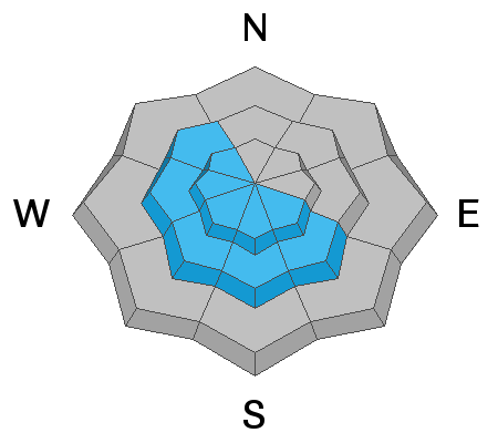
Recent snow and moderate-strong NNE winds overnight have drifted snow near and above treeline on NW-SW-SE aspects. There may also be some isolated, old, hard wind slabs hanging around in the high country on the northern half of the compass, but these will not be nearly as sensitive. Be on the lookout for fresh drifts and suspect smooth rounded areas that sound or feel hollow underneath. Additionally, softer wind slabs may just feel denser or punchy. You may find them on the leeward sides of ridge crests and terrain features such as gully walls and sub-ridges. Cross-loading and turbulent mountain winds can create slabs in unexpected places so be on the lookout for any wind-affected snow. Cracking and collapsing are obvious signs of instability and you should avoid steep slopes any time these signs are present.
Additional Information
It's amazing what the March 13/14 storm did for our snowpack which has skyrocketed to 92% of normal. Better late than never.
General Announcements
This forecast is from the U.S. Forest Service, which is solely responsible for its content. This forecast describes general avalanche conditions and local variations always occur.