AVALANCHE WARNING!! Tap for info

Forecast for the Moab Area Mountains

Dave Garcia
Issued by Dave Garcia on
Wednesday morning, March 20, 2024
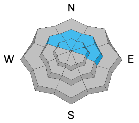
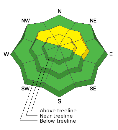
The avalanche danger is MODERATE. Although the likelihood is decreasing, it remains POSSIBLE to trigger avalanches in slabs of wind-drifted snow that formed during the storm on Friday and Saturday. These wind drifts exist near treeline and above on slopes that face NW-N-NE-E. If you are seeking bigger objectives, evaluate each slope carefully.
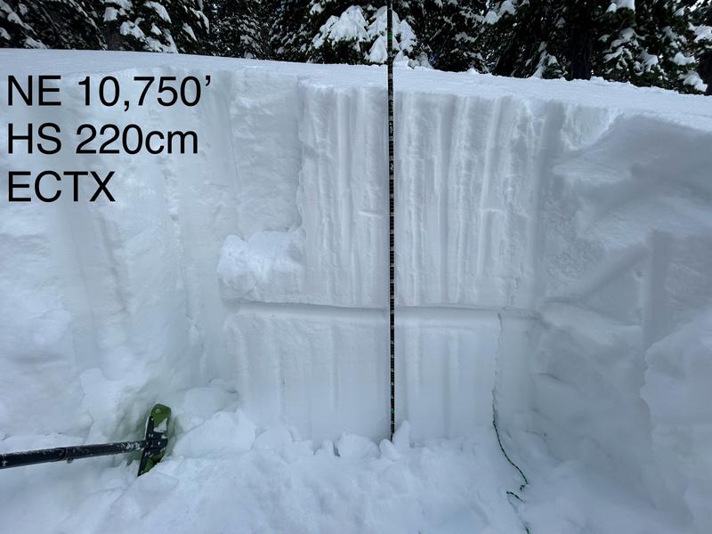
In isolated areas on northerly aspects near treeline and below, weak faceted snow exists two feet below the surface. The distribution of this layer is spotty at best, but it deserves to be on your radar today.
Low
Moderate
Considerable
High
Extreme
Learn how to read the forecast here
Special Announcements
Road Conditions: The Geyser Pass Road was plowed on Monday 3/18.
Grooming: Trails will be groomed today
***Support the UAC website rebuild by donating to our spring campaign. Save lives by making a donation today! HERE

The Banff Film Festival is returning to Moab on Thursday 3/21 and Friday 3/22 For tickets and information visit our event page.
Weather and Snow
6:00 a.m. Snow and Weather Data
24 Hour Snow 0" 72 Hour Snow 0" Season Total Snow 168" Depth at Gold Basin 63"
Winds on Pre-Laurel Peak: WNW 4-6 Temp 20° F Percent of Normal: 121%

Weather
The cut-off low to the South finally kicks out to the East, as high pressure continues to expand Eastward. Under clear skies, it is currently 20 degrees in Gold Basin. High temperatures will rise to 32 degrees today. Winds will be light out of the WNW, blowing 5-15 MPH. Tomorrow's weather will be a repeat of today. A gradual warming trend this week will see high temperatures climbing to 5-10 degrees above normal by Friday and Saturday. We are still on track for another storm system Saturday night into Sunday, which will bring cooler temps and widespread precipitation to the region.
General Conditions
Riding conditions took a slight hit, as warm temperatures on Monday made the snow surface damp on many aspects. Yesterday, I found a thin zipper crust even on Northerlies at the low and mid-elevations. Upper elevation shady slopes remain your best bet for cold dry snow, and there are still plenty of good turns to be had up there. Today will be warm and sunny, and the spring-like weather should help soften things a bit. Strong winds during the storm drifted the new snow, and many natural wind slab avalanches have been observed. Lingering slabs of wind-drifted snow near treeline and above remain your primary concern. Alpine terrain is not completely off-limits, but you will need to have a keen eye for observing and avoiding fat rounded pillows of drifted snow. In our travels on Monday, we found the recent slabs of drifted snow reactive to our weight and stability tests.
The weak layer of faceted snow that we have been tracking since 3/8, is still popping up in isolated areas. This layer is about two feet below the surface, and it exists in steep, sparsely treed, north-facing terrain near treeline and below. The distribution of this layer is spotty at best, but backcountry travelers should exercise caution when entering steep loosely treed slopes. When you do find this layer, it tends to be very obvious.
Snowpack and Weather Data
Gold Basin Storm Stake (10,000')
Gold Basin SNOTEL site (10,000')
SNOTEL site near Geyser Pass Winter Trailhead (9600')
Wind Station on Pre-Laurel Peak (11,400')
NWS forecast for the La Sal Mountains.
Recent Avalanches
In our travels on Sunday and Monday, we observed numerous avalanches that ran during the storm. Most of these avalanches involve slabs of wind-drifted snow. For a full updated list of recent avalanche activity click here.
This avalanche in Talking Mountain Cirque, appears to have failed deeper on a layer of facets. It is also possible that this avalanche in Horse Creek Chutes may have failed on facets as well. Both of these slopes are repeat runners, meaning they avalanched previously this season, leaving behind a shallow and weak snowpack.
The photo below shows avalanches from 3/16 that involved wind-drifted snow in the Meat Cleavers of Middle Cirque.
Ad
Avalanche Problem #1
Wind Drifted Snow
Type
Location
Likelihood
Size
Description
Strong winds on Friday and Saturday easily blew and drifted snow onto many slopes near treeline and above. Primary deposition occurred on slopes that face NW-N-NE-E. This resulted in a fairly widespread natural cycle over the weekend. In our recent travels, we encountered drifts up to two feet deep. These slabs are beginning to settle out, but it remains possible to trigger an avalanche 2 feet deep in these older drifts. If you are navigating through alpine terrain today, keep an eye out for fat, rounded, pillowy looking slabs of snow. Wind-drifted snow is stiffer and more compacted than non-drifted snow, and you will feel the difference when you cross onto a wind slab. Shooting cracks in drifted snow are a sure sign of instability.
This video was filmed on Monday, when we found sensitive drifts right at the treeline on a North facing slope.
Avalanche Problem #2
Normal Caution
Type
Location
Likelihood
Size
Description
We should be over the hump for wet activity on Solar aspects. These slopes took on the initial shock of heat on Monday, and got a sold refreeze last night. However, it is still springtime in the mountains, and that means it will be warm. Be alert to changing conditions on sunny slopes, and if you see signs of warming like roller balls, pinwheels, and sloppy wet snow, it is time to change aspects.
The weak layer of faceted snow that we have been tracking since 3/8, is still popping up in isolated areas. We have seen one skier-triggered avalanche associated with this layer back on 3/12. This layer exists on some Northerly facing terrain near treeline and below. We have been finding it on steep, sparsely treed slopes. This weak layer is not widespread by any means, but you should be aware that it exists. Exercise some caution when entering steep terrain near the tree line. If you dig down into the snow, you may find this weak layer buried about 2 feet below the surface. Where it exists, it is very obvious and easy to identify.
Additional Information
Want some more insight into the La Sal Mountains as well as the communal impacts of a tragic avalanche? Check out the latest UAC podcast with forecaster Eric Trenbeath where he discusses the range, it's often treacherous snowpack, and how the devastating avalanche in February, 1992, affected the Moab community.
Our avalanche beacon checker sign and beacon training park are up and running. A huge thanks to Talking Mountain Yurts for sponsoring those this season!
Sign up for forecast region-specific text message alerts. You will receive messages about changing avalanche conditions, watches, warnings and road plowing closures.
Follow us on Instagram @utavy_moab
General Announcements
This forecast is from the U.S.D.A. Forest Service, which is solely responsible for its content. This forecast describes general avalanche conditions and local variations always occur.