UDOT PLANNED AVALANCHE CLOSURES!!

Forecast for the Moab Area Mountains

Dave Kelly
Issued by Dave Kelly for
Sunday, March 19, 2023
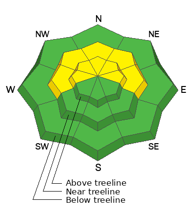
A MODERATE avalanche danger exists on northerly facing aspects near and above treeline where human triggered avalanches are possible. On southerly facing slopes at and above treeline and north facing slopes in the trees the avalanche danger is generally LOW.

Watch for cracking in the snow surface as a sign of instability. Avoid steep terrain with snow that that has a smooth, rounded, or pillowy appearance. On northerly aspects, it is still possible to trigger an older deeper wind slab. Even a small avalanche can be devastating in consequential terrain.
Low
Moderate
Considerable
High
Extreme
Learn how to read the forecast here
Special Announcements
Geyser Pass Road: The road was plowed on Friday. A snowpacked surface exists up high with muddy conditions down low.
Grooming: Trails were last groomed on Friday.
Weather and Snow
6:00 a.m. Snow and Weather Data
24 Hour Snow 0" 72 Hour Snow 0" Season Total Snow 257" Base Depth at Gold Basin 89"
Winds on Pre-Laurel Peak N/A Temp 2˚ F

Weather
Under partly cloudy skies it is currently 13˚F at the Geyser Pass trailhead. The Pre-Laurel wind station is down. Winds at the base of the La Sal's are blowing down canyon from the east-southeast and weather stations on the east side of the range and in the San Juan Mountains are showing winds blowing from a southerly direction.

For today, we will see increasing clouds and southwest winds blowing 10-20 MPH and gusting to the 30's. Expect to see temperatures from 18-22 ˚F.

The next Atmospheric River will bring a series of snowy weather through the region Mon-Wed. The National Weather Service has issued a Winter Weather Advisory from tonight at midnight until 800PM on Tuesday for areas over 8,000' where snowfall totals could exceed 2' of snow with 2-3" of water with strong winds.

General Conditions
Yesterday we had a great day traveling up the Laurel Highway into Talking Mountain Cirque and traversing out Gold Basin. We found wind-affected snow at and below the ridgetops. Southerly facing slopes were a breakable crust and the redeeming skiing was on lower angle protected north-east facing slopes well below the ridgelines. Read more about our tour HERE.
Winds have been blowing long and strong enough to create shallow fresh slabs of wind drifted snow and older slabs that formed during the storm are now buried under new wind-drifted snow. The danger for triggering an older slab is greatest on steep, northerly facing slopes above treeline. The March sun has done its work on southerly slopes and they were well crusted yesterday. As the day heats up, look for signs of loose, wet instability such as rollerballs, pinwheels, and sloppy wet snow and stay off those solar aspects later in the day. Increasing winds may keep this wet loose problem at bay today.

Snowpack and Weather Data
Gold Basin Storm Stake (10,000')
Gold Basin SNOTEL site (10,000')
SNOTEL site near Geyser Pass Winter Trailhead (9600')
Wind Station on Pre-Laurel Peak (11,400')
NWS forecast for the La Sal Mountains.
Recent Avalanches
A handful of natural avalanches ran during Wednesday's storm event on steep, northerly facing slopes.
Check out Chris' observation from Burro Ridge HERE and our observation from Mt. Peale HERE.
Ad
Avalanche Problem #1
Wind Drifted Snow
Type
Location
Likelihood
Size
Description
Yesterday we found north-east winds had been blowing and drifting surface snow into stiff wind slabs at the ridgetops and starting to sculpt the surface lower on the slope. Overnight the winds shifted to a southerly direction and are now loading slopes from the opposite direction. This means that the upper alpine terrain has been wind-affected and surface conditions will be variable.

Yesterday we observed northeast winds moving snow around on the Pre-Laurel Peak Ridgeline just below the weather station.
Additional Information
Thanks to everyone who made it out the Banff Film Festival the last two nights. We had an awesome turnout and a great selection of movies were shown.

Persistent Weak Layers - If you've been following along, you know we've been tracking various weak layers in the snowpack, the most prominent of which was buried by a storm on Valentine's Day. Throughout this period, the location of this weak layer was spotty, and was only occasionally reactive to stability tests. Two rounds of heavy snowfall have failed to produce avalanches on any weak layer, and we have determined they are not widespread, or reactive enough to be deemed a problem. Isolated areas with buried weak snow may still remain, primarily on northerly aspects in wind sheltered areas. You can minimize your exposure by avoiding very steep, radical terrain in these areas, and by practicing safe travel techniques.
General Announcements
This forecast is from the U.S.D.A. Forest Service, which is solely responsible for its content. This forecast describes general avalanche conditions and local variations always occur. This forecast will be updated by 7:30 tomorrow morning.