Forecast for the Moab Area Mountains

Eric Trenbeath
Issued by Eric Trenbeath for
Sunday, March 17, 2024
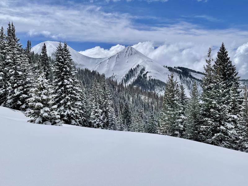
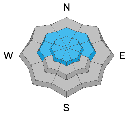
Heavy snowfall and periods of high winds over the past few days caused a spike in avalanche danger. We are now trending down to an overall MODERATE danger for human triggered avalanches involving slabs of wind drifted snow, but areas of CONSIDERABLE danger may still exist on steep, wind loaded, northerly aspects above treeline. Avoid steep, wind drifted slopes, especially those with a northerly component to their aspect. Dry, loose avalanches may also be possible in steep terrain.
In isolated areas on northerly aspects, a triggered wind slab may step down to a buried weak layer of faceted snow. Far from widespread, this has been popping up from time to time, and the only sure way to know if it's there is to dig for it.
If the sun pokes out today, we'll see a MODERATE danger for loose, wet avalanches on sun exposed slopes. Signs of instability include rollerballs, pinwheels, and sloppy wet snow. ​​​​​​
Low
Moderate
Considerable
High
Extreme
Learn how to read the forecast here
Special Announcements
Road Conditions: The Geyser Pass Road is not plowed and driving conditions are sporty. There's now over a foot of snow at the parking lot and the road is drifted. 4x4 and good tires are necessary. It's a good idea to carry chains. Consider parking at Trans La Sal today.
Grooming: LUNA continues to pack in the new snow but trails remain covered.
***Support the UAC website rebuild by donating to our spring campaign. Save lives by making a donation today! HERE

The Banff Film Festival is returning to Moab on Thursday 3/21 and Friday 3/22 For tickets and information visit our event page.
Weather and Snow
6:00 a.m. Snow and Weather Data
24 Hour Snow 6" 72 Hour Snow 15" Season Total Snow 168" Depth at Gold Basin 69"
Winds on Pre-Laurel Peak: ENE 10-15 Temp 16° F Percent of Normal: 119%

Weather
The cutoff low responsible for this long duration storm continues to churn over Arizona. A plume of moisture feeding into the 4 Corners will keep the threat of snow showers alive in our area this morning although accumulation will be minimal. By mid-day, we should at least see some partial clearing that will give the strong March sun a chance to beat down before another chance for light, convective showers and possibly some thunder develops by late afternoon. Monday looks to be mostly sunny with generally quiet weather for the upcoming week.
General Conditions
We've picked up 21" of snow since Wednesday night, and by all accounts, that's what the skiing and riding feels like. Yesterday's 6" capped some of the wind affected snow that fell Thu-Fri, and observers yesterday reported excellent powder conditions with no storm snow slab. Brian Sparks reported rapid warming and some sun affect as the clouds broke for a bit yesterday. Read his observation here. If the sun comes out again today you'll want to pay attention to signs of loose, wet, instability such as roller balls or pinwheels on sun exposed slopes, but your primary concern will be areas of wind drifted snow near and above treeline, primarily on steep, northerly aspects. You may also encounter some dry, loose snow sluffs if you venture into steep terrain.
Additionally, we have been tracking a weak layer of faceted snow in the upper pack. This layer is currently buried about a 18"-24" below the surface. We have been finding this very weak snow on some northerly facing slopes near treeline and below. The distribution of this layer is spotty at best, but it seems to be popping up in isolated areas of steep, sparsely treed terrain and it has produced a skier triggered avalanche. For more details on this weak layer see Dave's observations #1, #2. Dial back your terrain choices for now and let's see how the recent snow affects this layer.
Brian Sparks snapped this photo during a sunny moment yesterday. Note cross-loading and wind drifted areas along the chutes in "Gravel Pit Lanes."
Snowpack and Weather Data
Gold Basin Storm Stake (10,000')
Gold Basin SNOTEL site (10,000')
SNOTEL site near Geyser Pass Winter Trailhead (9600')
Wind Station on Pre-Laurel Peak (11,400')
NWS forecast for the La Sal Mountains.
Ad
Avalanche Problem #1
Wind Drifted Snow
Type
Location
Likelihood
Size
Description
Strong easterly winds early in the storm cycle blew and drifted snow on to all aspects, particularly in the high country. SE has been the primary wind direction but we've seen winds from the NE as well. Primary deposition has been on leeward, north and westerly aspects, but cross-loading has also been a factor. I'm personally not comfortable yet with steep, wind loaded, northerly facing slopes. Human triggered avalanches 2' deep or more remain possible to likely in these areas, especially in the high country. I'd give it another day or two before stepping out into this kind of terrain.
Avalanche Problem #2
Wet Snow
Type
Location
Likelihood
Size
Description
The recent snow will be at it's most vulnerable state when the strong March sun hits it for the first time. Some exposed slopes were touched yesterday, but today should see a little more widespread warming of the snow surface. If and when the sun comes out, be alert to signs of loose, wet snow instability such as rollerballs or pinwheels, and stay off of, and out from under steep slopes if they become wet and sloppy.
Additional Information
Want some more insight into the La Sal Mountains as well as the communal impacts of a tragic avalanche? Check out the latest UAC podcast with forecaster Eric Trenbeath where he discusses the range, it's often treacherous snowpack, and how the devastating avalanche in February, 1992, affected the Moab community.
Our avalanche beacon checker sign and beacon training park are up and running. A huge thanks to Talking Mountain Yurts for sponsoring those this season!
Sign up for forecast region-specific text message alerts. You will receive messages about changing avalanche conditions, watches, warnings and road plowing closures.
Follow us on Instagram @utavy_moab
General Announcements
This forecast is from the U.S.D.A. Forest Service, which is solely responsible for its content. This forecast describes general avalanche conditions and local variations always occur.