Forecast for the Moab Area Mountains

Eric Trenbeath
Issued by Eric Trenbeath for
Friday, February 8, 2019
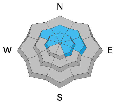
The avalanche danger remains CONSIDERABLE on steep, wind drifted slopes that face NW-N-E at mid and upper elevations. In addition to wind drifted snow, avalanches breaking down into buried persistent weak layers are also likely. Most south facing, and low elevation terrain, has MODERATE to LOW danger.
Low
Moderate
Considerable
High
Extreme
Learn how to read the forecast here
Special Announcements
We are sorry to report that a snowmobiler is missing in an avalanche east of Beaver, Utah near Circleville Mountain. Search and Rescue operations are under way this morning. We will update this situation as more information becomes available.
We will be offering a Backcountry 101 avalanche course on Feb 8, 9. It's a great way to up your avalanche knowledge with both classroom, and hands on field instruction. Click here for more details and to register. Much thanks to Moab Gear Trader for sponsoring this course! Please visit them for all of your winter backcountry needs.
Weather and Snow
Since Sunday, we've had 21" of new snow and conditions remain excellent in mid and lower elevation sheltered areas. Strong SW winds blew throughout the stormy period, scouring southerly aspects, and drifting snow onto northerlies. By Thursday, winds had backed off and shifted to the northwest. On Wednesday, Chris Jacobsen and I took out the sleds and found deep powder conditions for carving and turning, especially over on the east side of the range where more than 2' of snow has piled up. I also received reports of excellent skiing in the woods from Dave Garcia and company, read his report here. With all the new snow, wind, and a weak underlying snowpack, you'll want to stick to sheltered, low angle, terrain for the safest, and best conditions.
Base depth in Gold Basin: 58"
New snow totals in Gold Basin (10,000')
Snow totals at the Geyser Pass Trailhead (9600')
Wind, temperature, and humidity on Pre Laurel Peak (11,700')
National Weather Service point forecast.
Ad
Avalanche Problem #1
Wind Drifted Snow
Type
Location
Likelihood
Size
Description
Strong southerly winds earlier this week have blown and drifted snow on to northerly aspects, and human triggered avalanches are likely on steep, wind drifted slopes with those aspects. At upper elevations, you may find wind slabs on all sides of the compass on the leeward signs of terrain features such as sub-ridges and gully walls. Avoid, steep, wind drifted terrain.
Avalanche Problem #2
Persistent Weak Layer
Type
Location
Likelihood
Size
Description
The new snow doesn't appear to have caused any natural avalanches down to our buried persistent weak layers, but snow pits and stability tests conclude that they are very much alive and well. Our primary layer of concern is the early December snow that has turned into weak, sugary facets on top of the October crust. There is also a buried layer of facets that existed near the surface before Sunday's storm. With 21" of new snow, and almost 2" of water weight since then, I'm going to assume these layers are guilty until proven innocent. This means assuming that deep and dangerous, human triggered avalanches are likely, primarily on steep slopes at mid and upper elevations that face NW-N-E.
General Announcements
Your information can save lives. If you see anything we should know about, please help us out by submitting snow and avalanche observations HERE. You can also call me at 801-647-8896, or send me an email: [email protected].
Support the UAC through your daily shopping. When you shop at Smith's, or online at REI, Backcountry.com, Patagonia, NRS, Amazon, eBay by clicking on these links, they donate a portion of your purchase to the UAC. If you sell on eBay, you can have your See our Affiliate Page for more details on how you can support the UAC when you shop
This advisory is from the U.S.D.A. Forest Service, which is solely responsible for its content. This advisory describes general avalanche conditions and local variations always occur.