Forecast for the Moab Area Mountains

Eric Trenbeath
Issued by Eric Trenbeath for
Monday, February 4, 2019
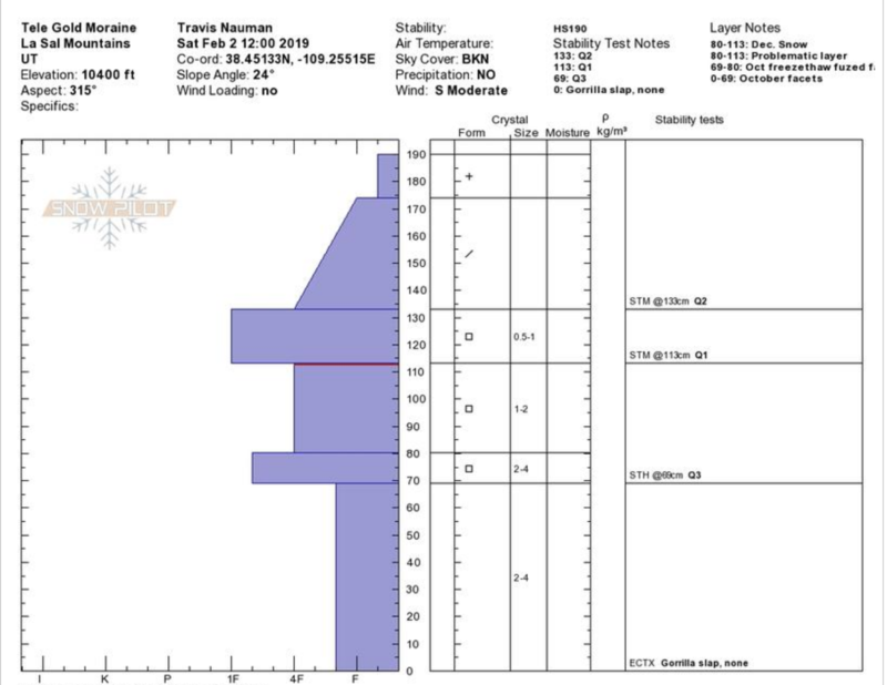
Blowing and drifting snow have created dangerous avalanche conditions and the avalanche danger is CONSIDERABLE today. Human triggered avalanches are likely on steep, wind drifted slopes, and natural avalanches are possible off the steep, higher peaks. Above treeline, shallow wind slabs may be found on all aspects, but deeper drifts will have formed on slopes facing NW-N-E. Avoid steep slopes with recent deposits of wind drifted snow, and stay out from under high, steep faces that have a northerly aspect.
Low
Moderate
Considerable
High
Extreme
Learn how to read the forecast here
Special Announcements
We will be offering a Backcountry 101 avalanche course on Feb 8, 9. It's a great way to up your avalanche knowledge with both classroom, and hands on field instruction. Click here for more details and to register. Much thanks to Moab Gear Trader for sponsoring this course! Please visit them for all of your winter backcountry needs.
Weather and Snow
I don't have any data from Pre Laurel Peak this morning, but surrounding stations suggest SW winds averaging 25-30 mph along ridge tops with gusts into the 40's. Yesterday's storm brought 5"-6" of dense snow to the mountains, accompanied by strong SW winds. Today look for mostly cloudy skies, a chance for snow, and continued blustery conditions and strong SW winds. Temps will climb up to near 30 degrees. They are currently in the low 20's at 10,000'. We'll see unsettled weather today into tomorrow before the next significant storm arrives Tue night or Wed.
Base depth in Gold Basin: 56"
New snow totals in Gold Basin (10,000')
Snow totals at the Geyser Pass Trailhead (9600')
Wind, temperature, and humidity on Pre Laurel Peak (11,700')
National Weather Service point forecast.
Blustery out there yesterday!
Recent Avalanches
No recent activity to report.
Ad
Avalanche Problem #1
Wind Drifted Snow
Type
Location
Likelihood
Size
Description
Human triggered avalanches involving wind drifted snow are likely today, and we may also see some natural activity off the higher, steep faces. Sustained strong southerly winds have been blowing and drifting snow for the past 24 hours, and you may find shallow wind slabs on the lee sides of terrain features on all sides of the compass at upper elevations. Deeper drifts will be found on slopes facing NW-NE-E. Stay out from under high, steep faces with these aspects, and avoid steep slopes with recent deposits of wind drifted snow.
Avalanche Problem #2
Persistent Weak Layer
Type
Location
Likelihood
Size
Description
Drifting snow has added additional stress to buried, persistent weak layers in the snowpack. Our primary layer of concern is the early December snow that has turned to weak, sugary facets. Today there remains a very real possibility for triggering a deep and dangerous avalanche on this weak layer. The danger is greatest on steep, upper elevation slopes facing NW-N-E, but in some areas the problem wraps around to W and SE facing slopes.
Travis Nauman and Reed Kennard noted strengthening persistent weak layers in this observation but we aren't out of the woods yet.
Here is their snowpit from a NE aspect at 10,400'. Layer of conncern continues to be facets from early December.
General Announcements
Your information can save lives. If you see anything we should know about, please help us out by submitting snow and avalanche observations HERE. You can also call me at 801-647-8896, or send me an email: [email protected].
Support the UAC through your daily shopping. When you shop at Smith's, or online at REI, Backcountry.com, Patagonia, NRS, Amazon, eBay by clicking on these links, they donate a portion of your purchase to the UAC. If you sell on eBay, you can have your See our Affiliate Page for more details on how you can support the UAC when you shop
This advisory is from the U.S.D.A. Forest Service, which is solely responsible for its content. This advisory describes general avalanche conditions and local variations always occur.