Forecast for the Moab Area Mountains

Dave Garcia
Issued by Dave Garcia for
Wednesday, February 28, 2024
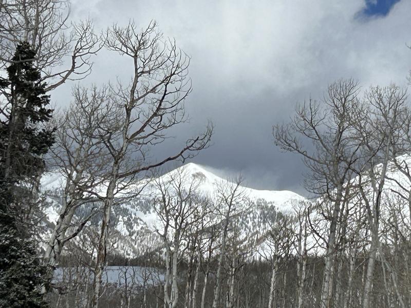
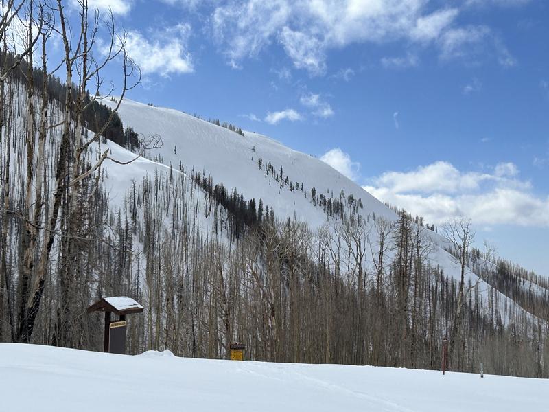
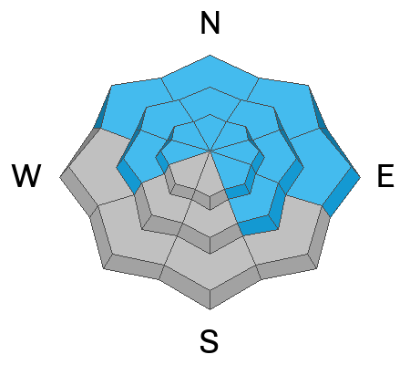
Strong winds have been all over the map, blowing and drifting recent storm snow into fresh slabs on all aspects near treeline and above. The avalanche danger is MODERATE and it is POSSIBLE for riders to trigger avalanches 6" to 12" deep in wind-drifted snow. The danger is most prominent on Northerly aspects where deeper drifts extend further down slope than you might expect.
Although it is becoming less likely, very deep and dangerous avalanches failing on a persistent weak layer remain POSSIBLE on slopes that face W-N-E-SE. The danger is most prominent on slopes that face NW-N-NE-E and you are most likely to trigger one of these avalanches in steep rocky terrain with a shallow snowpack.
Low
Moderate
Considerable
High
Extreme
Learn how to read the forecast here
Special Announcements
We are seeking a passionate individual to join us as Executive Director of the nonprofit Utah Avalanche Center. Click here for more information.
Road Conditions: The Geyser Pass Road is not plowed, expect to find a few inches of snow on top of a slick surface. There may be deeper drifts near the top of the road.
Grooming: Trails have not been groomed.
Weather and Snow
6:00 a.m. Snow and Weather Data
24 Hour Snow 3" 72 Hour Snow 3" Season Total Snow 135" Depth at Gold Basin 50"
Winds on Pre-Laurel Peak: NNW 17 G 22 TempPercent of Normal: 98%

Weather
Zonal flow aloft has set up overhead, advecting warmer air into the mid and upper levels. This is setting up a strong inversion across the region that will trap colder air in the valleys. It is a chilly 4 degrees in Gold Basin this morning. Plenty of sunshine will help to warm things up, and mountain temperatures should reach the mid-twenties. The strong winds will start to back off this morning, and will blow out of the NW at 5-10 MPH. Winds will shift and blow out of the WSW this afternoon. Temperatures will trend upward throughout the week with highs expected to peak around 10 degrees above normal by Friday afternoon. Winds will also be on the increase each day ahead of our next storm, which will impact the mountains this weekend.
General Conditions
Today will be a beautiful, cold, crisp winter day in the mountains. There is three inches of new snow and plenty of sunshine. Take advantage of the new snow and light winds today, as strong winds return over the next few days. Despite the strong winds, I was able to find great skiing yesterday in the trees. Three inches and some wind can really provide a nice refresh. The winds were all over the map with this storm creating fresh slabs of wind-drifted snow on all aspects. With only three inches of new snow, these drifts will be shallow, but they will remain sensitive to the weight of a skier or rider again today. Backcountry travelers should look for and avoid any slopes that have been recently loaded. Additionally, it remains possible to trigger very deep and dangerous avalanches failing down to our early season persistent weak layer. You are most likely to trigger one of these avalanches in areas with a shallow snowpack, particularly in steep, rocky, more radical terrain in the alpine.
I was out and about enjoying the new snow yesterday, and you can see a report of my travels here.
I poked around at a variety of aspects on Monday to get a lay of the land ahead of the storm. See Monday's report here.
Plumes of snow blow off Pilot Mt during yesterday's strong winds.
Snowpack and Weather Data
Gold Basin Storm Stake (10,000')
Gold Basin SNOTEL site (10,000')
SNOTEL site near Geyser Pass Winter Trailhead (9600')
Wind Station on Pre-Laurel Peak (11,400')
NWS forecast for the La Sal Mountains.
Ad
Avalanche Problem #1
Wind Drifted Snow
Type
Location
Likelihood
Size
Description
The storm came in with strong SW winds and I watched leeward slopes get loaded all day yesterday. Overnight, strong winds blew out of the North, blowing and drifting snow onto Southerly aspects as well. Today, fresh slabs of wind-drifted snow will be found on all aspects near treeline and above. These slabs will be 6-12 inches deep. The deepest drifts will be most prominent on Northerly facing slopes and with such a long duration of winds, these slabs will exist further down the slope than you might expect. Look for fresh drifts around any terrain features that facilitate loading, such as gully walls, under cliff bands, along sub-ridges, in scoops, saddles, and sinks. Hollow, drum-like sounds and/or cracking are good signs that you have found a fresh drift.
Look closely at this photo of Noriega's Face and you'll notice some fat, rounded pillows of snow that indicate recent loading. You'll want to avoid slopes that have this appearance.
Avalanche Problem #2
Persistent Weak Layer
Type
Location
Likelihood
Size
Description
Yesterday's storm only dropped three inches of snow and this will not be enough to affect the deeply buried persistent weak layer. It will take the weight of a human in just the right spot to trigger one of these avalanches. Likely trigger points are steep, rocky, radical terrain with a shallow snowpack. The odds of triggering one of these slides continue to decrease, but it is not impossible. If you were to trigger one of these avalanches, it would break out deep and wide, and could be potentially unsurvivable. Stack the odds in your favor by skiing in areas with a deeper snowpack.
If you happen to be poking around in alpine terrain, and you were to trigger a slab of wind-drifted snow, it could step down to the persistent weak layer, causing a much larger and much more dangerous avalanche.
Additional Information
Want some more insight into the La Sal Mountains as well as the communal impacts of a tragic avalanche? Check out the latest UAC podcast with forecaster Eric Trenbeath where he discusses the range, it's often treacherous snowpack, and how the devastating avalanche in February, 1992, affected the Moab community.
Our avalanche beacon checker sign and beacon training park are up and running. A huge thanks to Talking Mountain Yurts for sponsoring those this season!
Sign up for forecast region-specific text message alerts. You will receive messages about changing avalanche conditions, watches, warnings and road plowing closures.
Follow us on Instagram @utavy_moab
General Announcements
This forecast is from the U.S.D.A. Forest Service, which is solely responsible for its content. This forecast describes general avalanche conditions and local variations always occur.