Forecast for the Moab Area Mountains

Eric Trenbeath
Issued by Eric Trenbeath for
Thursday, February 22, 2024
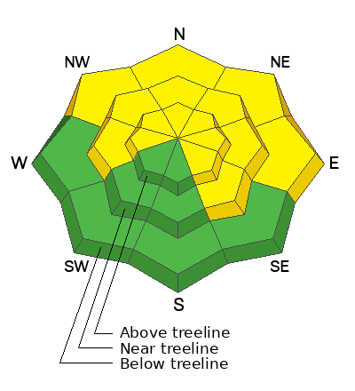
The overall danger remains MODERATE. Deep and dangerous human-triggered avalanches remain possible on steep slopes that face W-N-E-SE. The danger is most prominent on slopes that face NW-N-E. You are most likely to trigger an avalanche in thin snowpack areas. You can reduce your risk by avoiding steep, rocky areas and slopes with complex terrain features.

Strong southerly winds have produced stiff slabs of wind-drifted snow above treeline where it is possible to trigger small avalanches on slopes that face W-N-SE.

A generally LOW danger exists on slopes facing S-SW.
Low
Moderate
Considerable
High
Extreme
Learn how to read the forecast here
Special Announcements
We are seeking a passionate individual to join us as Executive Director of the nonprofit Utah Avalanche Center. Click here for more information.
Road Conditions: The Geyser Pass Road is plowed but snowpacked and slick!
Grooming: LUNA last groomed Gold Basin through Geyser Pass and set classic track on Sunday.
Weather and Snow
6:00 a.m. Snow and Weather Data
24 Hour Snow T" 72 Hour Snow 1" Season Total Snow 132" Depth at Gold Basin 49"
Winds on Pre-Laurel Peak: NW 5-10 Temp 13° Percent of Normal: 100%

Weather
Cool, westerly flow has taken over and mountains temperatures have tanked into the low teens. Look for sunny skies today with light northwesterly winds, and high temperatures climbing back up to near 30 degrees at 10,000'. We'll remain high and dry through the weekend with the next storm possibility shaping up for early next week. Stay tuned.
General Conditions
Thankfully, the relentless southerly winds have finally backed off, but after blowing for just over three straight days it's getting more difficult to find good skiing. Exposed southerly aspects are stripped and scoured while cross-loading and blowing have affected slopes facing W-N-SE. Mid and low elevation, sheltered, northerly aspects harbor the best chances for finding decent snow. Near and above treeline, stiff slabs of wind drifted snow have formed on northerly aspects. They'll be more stubborn today, but unfortunately exist on the same slopes where we have our lingering persistent weak layer problem. The likelihood of triggering a deep avalanche down into weak, faceted snow has decreased significantly, but keep the odds in your favor by avoiding areas of steep, rocky, radical terrain, or slopes with complex terrain features. Thinner snowpack areas remain suspect where your weight can much more easily affect the weak layer. Pull out your shovel, or simply probe around. I'd personally like to see close to 200 cms of snow before I'd feel good about skiing something steep.
Although this messaging may grow tiresome, the threat remains real. Over in the San Juan Mountains of Colorado, where they have a similar snowpack, folks continue to trigger dangerous avalanches failing on deeply buried faceted weak layers including this avalanche that caught and buried two people.
Check out this video Dave made for a discussion of our current, "Low probability - high consequence" scenario.
Snowpack and Weather Data
Gold Basin Storm Stake (10,000')
Gold Basin SNOTEL site (10,000')
SNOTEL site near Geyser Pass Winter Trailhead (9600')
Wind Station on Pre-Laurel Peak (11,400')
NWS forecast for the La Sal Mountains.
Recent Avalanches
See the full list of avalanche activity here
Ad
Avalanche Problem #1
Persistent Weak Layer
Type
Location
Likelihood
Size
Description
Persistent weak layers (PWL) of faceted snow that formed in November and December remain our primary concern. We saw widespread natural avalanche activity on these layers between Fec 2-8. The likelihood of triggering an avalanche on a deeply buried PWL has decreased significantly, but it is still possible. We are now in a low likelihood, high consequence scenario. If you are stepping out into avalanche terrain, evaluate each slope on an individual basis. Aim to ride in areas with a deep snowpack. Avoid steep, rocky terrain, thinner areas along slope margins, and steep, blind rollovers or convexities. These are all likely trigger points.
Avalanche Problem #2
Wind Drifted Snow
Type
Location
Likelihood
Size
Description
Strong southerly winds have blown and drifted snow into shallow stiff slabs, primarily on upper elevation, northerly facing slopes. Some cross-loading may have also occurred on slopes facing W and SE. These will be more stubborn to trigger today but keep an eye out for smooth, rounded areas of wind drifted snow, or hard surfaces that sound or feel hollow underneath. On northerly aspects, winds slabs have developed in precisely the same areas where we have our persistent weak layer problem, and these slopes should be approached with extra caution. Avoid, areas of steep, rocky, complex terrain where a triggered wind slab could result in a much deeper and more dangerous avalanche.
Additional Information
Want some more insight into the La Sal Mountains as well as the communal impacts of a tragic avalanche? Check out the latest UAC podcast with forecaster Eric Trenbeath where he discusses the range, it's often treacherous snowpack, and how the devastating avalanche in February, 1992, affected the Moab community.
Our avalanche beacon checker sign and beacon training park are up and running. A huge thanks to Talking Mountain Yurts for sponsoring those this season!
Sign up for forecast region-specific text message alerts. You will receive messages about changing avalanche conditions, watches, warnings and road plowing closures.
Follow us on Instagram @utavy_moab
General Announcements
This forecast is from the U.S.D.A. Forest Service, which is solely responsible for its content. This forecast describes general avalanche conditions and local variations always occur.