Join us at our 2nd Annual Blizzard Ball

Forecast for the Moab Area Mountains

Eric Trenbeath
Issued by Eric Trenbeath on
Monday morning, February 22, 2021
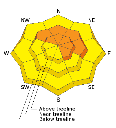
The avalanche danger remains CONSIDERABLE on steep slopes facing NW-NE-SE near and above treeline. In these areas, fresh deposits of wind drifted snow have added stress to buried persistent weak layers, and deep and deep and dangerous human-triggered avalanches up to 4' deep are likely. The avalanche danger is MODERATE on most south-facing slopes near treeline and below and human-triggered avalanches remain possible. As the day heats up, be alert to signs of loose wet instability such as rollerballs or pinwheels and stay out out from under steep slopes if they become wet and sloppy.
Low
Moderate
Considerable
High
Extreme
Learn how to read the forecast here
Special Announcements
The Geyser Pass Road was plowed on Tuesday, but 3"-5" of new snow has fallen since then. 4x4 with good tires is recommended.
The Lower Utah Nordic Alliance (LUNA) last packed and rolled the lower meadow through Gold Basin on Thursday.
Weather and Snow
24 Hour Snow 0" 72 Hour Snow 2" Base Depth in Gold Basin 50" Wind NW 10-15 G25 Temp 9F
Another beautiful day is on tap with sunny skies, light to moderate WNW ridgetop winds, and high temps at 10,000' near 30F. We'll see more of the same for the next couple of days before a weak disturbance brings clouds and a slight chance for snow on Wed.
Wind, temperature, humidity on Pre Laurel Peak (11,700')
Snotel site near Geyser Pass Trailhead (9600')
Storm totals at the Gold Basin study plot (10,000')
Snowpack Discussion
It was another beautiful day in the mountains yesterday with a surprising amount of soft snow still to be found. SW aspects are crusted over and shifting winds in the high country have also affected exposed surfaces, but sheltered slopes out of the wind zone still have good snow. Just remember to keep your slope angles under 30 degrees. Persistent weak layers of sugary, faceted snow still exist on most aspects, but it's been more than a week since the last significant load. Travis Nauman reported signs of a strengthening snowpack in this observation. By contrast, I also received this observation from the Corksrew Glades. where collapsing and whumphing were reported to be fairly widespread in that dark and shady zone. Bottom line is that a weak, faceted snowpack is not to be trusted, especially on northerly aspects where deep and dangerous, human triggered avalanches remain likely.
Safe riding for conditions on February 21:
Recent Avalanches
It's been a week since any natural avalanche activity has occurred. Natural activity from last weekend's storm was surprisingly low. With the current poor snowpack structure, this means many steep slopes are hanging in balance just waiting for a human trigger.
Ad
Avalanche Problem #1
Persistent Weak Layer
Type
Location
Likelihood
Size
Description
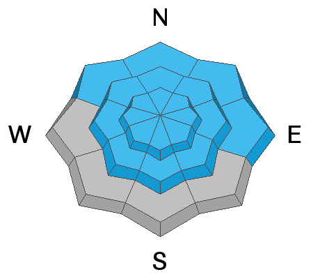
More than 2' of snow has fallen since last weekend adding significant stress to buried persistent weak layers of loose, sugary, faceted snow. On steep slopes facing NW-N-SE, deep and dangerous human triggered avalanches 2'-4' deep remain likely. Weak layers of faceted snow exist on all aspects and the recent snow load has heightened concerns on south facing slopes. Persistent weak layer problems are deceptive and avoidance of avalanche terrain, or slopes steeper than about 30 degrees is the only sure bet.
Avalanche Problem #2
Wind Drifted Snow
Type
Location
Likelihood
Size
Description
SW-NW winds over the past few days have formed fresh deposits of wind drifted snow, primarily in upper elevation, wind-exposed terrain. They are not likely to be very sensitive today, but they have added stress to slopes with buried persistent weak layers, and once triggered they will likely produce deeper and even more dangerous avalanches. Wind drifts are recognizable by their smooth, rounded appearance, and they may sound or feel hollow underneath. Avoid steep slopes that have recent deposits of wind drifted snow.
Avalanche Problem #3
Wet Snow
Type
Location
Likelihood
Size
Description
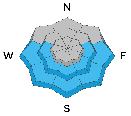
With a strong sun and warm temps today we may some some loose, wet slide activity on sun exposed slopes. Be alert to signs of loose wet instability such as rollerballs or pinwheels and stay out out from under steep slopes if they become wet and sloppy.
Additional Information
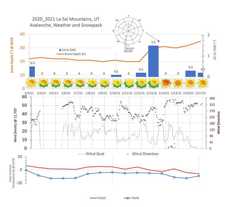
Chris Benson has compiled the following data for the period between Feb 3 - 17. Note the single greatest loading event of the season with more than 15" of snow 1.5" Snow Water Equivalent (SWE) in a 12 hour period on Feb 13.
General Announcements
This forecast is from the U.S. Forest Service, which is solely responsible for its content. This forecast describes general avalanche conditions and local variations always occur.