Join us at our 2nd Annual Blizzard Ball

Forecast for the Moab Area Mountains

Eric Trenbeath
Issued by Eric Trenbeath on
Friday morning, February 19, 2021
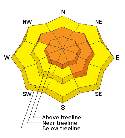
The avalanche danger remains CONSIDERABLE on steep slopes on all aspects above treeline, and on slopes facing NW-NE-SE near treeline. Blowing and drifting of new snow has added additional stress to buried persistent weak layers and deep and dangerous human-triggered avalanches up to 4' deep remain likely. The avalanche danger is MODERATE on mid and lower elevations slopes facing S-W and human-triggered avalanches remain possible in these areas.
Low
Moderate
Considerable
High
Extreme
Learn how to read the forecast here
Special Announcements
The Geyser Pass Road was plowed on Tuesday, but 3"-5" of new snow has fallen since then. 4x4 with good tires is recommended.
The Lower Utah Nordic Alliance (LUNA) packed and rolled the lower meadow through Gold Basin yesterday.
Weather and Snow
24 Hour Snow 0" 72 Hour Snow 10" Base Depth in Gold Basin 52" Wind WNW 10-15 Temp 11F
Skies are cloudy, and WNW winds overnight have been mostly light except for about a three-hour period between 8:00-11:00 p.m. where they bumped up into the 20-25 mph range. A weak disturbance on a NW flow is currently passing by to the north. We should see some partial clearing later today as this system moves on followed by a similar system on Saturday. Again favoring points north, we shouldn't see much out of this beyond clouds, an increase in winds, and a slight chance for snow. Sunday and Monday look to be sunny and dry with long-range models not currently showing much on the horizon.
Wind, temperature, humidity on Pre Laurel Peak (11,700')
Snotel site near Geyser Pass Trailhead (9600')
Storm totals at the Gold Basin study plot (10,000')
Snowpack Discussion
The good news is that conditions are as good as they've been all season and that cold temps and relatively well-behaved winds have preserved the fine powder snow. The bad news is that we have persistent weak layers of sugary faceted snow on most aspects, and the last two storm events have heaped a significant load of snow on top of these weak layers. Wind loaded, northerly aspects are the most likely areas to trigger deep, and dangerous avalanches, but you can also trigger avalanches on more southerly aspects. Avoidance of avalanche terrain or slopes steeper than about 30 degrees is the only sure strategy right now.
Conditions report from Thursday, Feb 18:
Recent Avalanches
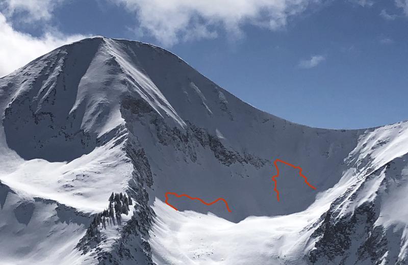
In our travels on Sunday, we observed these two natural avalanches from a distance beneath the N Face of Mount Tukuhnikivatz in Red Snow Cirque. Somewhat "pockety" in nature, they nevertheless had crowns up to 4' deep and could have easily buried or killed someone. Human-triggered avalanches such as this remain likely.
Charlie Ramser was up in Horse Creek Monday where he reported seeing this avalanche.
Ad
Avalanche Problem #1
Persistent Weak Layer
Type
Location
Likelihood
Size
Description
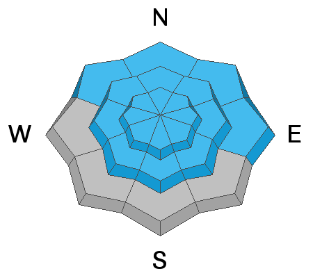
More than 2' of snow has fallen since last weekend adding significant stress to buried persistent weak layers of loose, sugary, faceted snow. On steep slopes facing NW-N-SE, deep and dangerous human triggered avalanches 2'-4' deep remain likely. Weak layers of faceted snow exist on all aspects and the recent snow load has heightened concerns on south facing slopes. Persistent weak layer problems are deceptive and avoidance of avalanche terrain, or slopes steeper than about 30 degrees is the only sure bet.
Avalanche Problem #2
Wind Drifted Snow
Type
Location
Likelihood
Size
Description
Moderate to strong NW winds on Wed night blew and drifted the most recent low density snow. Today, continue to be on the lookout for recent deposits of wind drifted snow on the leeward sides of ridge crests and terrain features, primarily in upper elevation, wind-exposed terrain. Fresh wind drifts are recognizable by their smooth, rounded appearance and cracking is a sign of instability. On northerly aspects, fresh drifts have added additional stress to buried persistent weak layers, and once triggered they will likely produce deeper and even more dangerous avalanches. Avoid steep slopes with recent deposits of wind drifted snow.
General Announcements
This forecast is from the U.S. Forest Service, which is solely responsible for its content. This forecast describes general avalanche conditions and local variations always occur.