Join us at our 2nd Annual Blizzard Ball

Forecast for the Moab Area Mountains

Eric Trenbeath
Issued by Eric Trenbeath on
Sunday morning, February 14, 2021
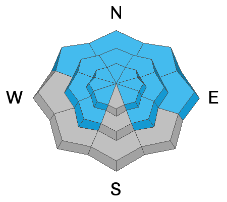
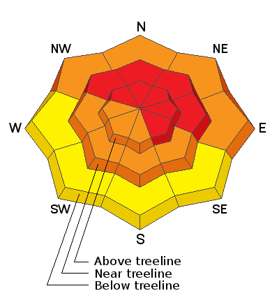
Dangerous avalanche conditions exist! New and wind drifted snow has stressed buried persistent weak layers to their breaking point and the avalanche danger is HIGH on steep slopes near treeline and above that face NW-NE-SE. Deep and dangerous human triggered avalanches are very likely in these areas. Additionally, avalanches involving the most recent snow can be triggered on all aspects at all elevations. Backcountry travelers need to have excellent route finding skills and know how to stay off of and out from under steep, avalanche prone terrain.
Low
Moderate
Considerable
High
Extreme
Learn how to read the forecast here
Avalanche Warning
THE FOREST SERVICE UTAH AVALANCHE CENTER IN MOAB HAS ISSUED A BACKCOUNTRY AVALANCHE WARNING.
* TIMING... 6 AM MST SUNDAY THROUGH 6 AM MST MONDAY.
* AFFECTED AREA...FOR THE LA SAL AND ABAJO MOUNTAINS OF SOUTHEASTERN UTAH
* AVALANCHE DANGER...THE AVALANCHE DANGER HAS RISEN TO HIGH.
* REASON/IMPACTS...HEAVY SNOW COMBINED WITH WIND HAS CREATED WIDESPREAD AREAS OF UNSTABLE SNOW AND DANGEROUS AVALANCHE CONDITIONS EXIST. BOTH HUMAN TRIGGERED AND NATURAL AVALANCHES ARE LIKELY. STAY OFF OF AND OUT FROM UNDER SLOPES STEEPER THAN 30 DEGREES. AVOID TRAVEL IN AVALANCHE TERRAIN.
Special Announcements
Test your avalanche advisory comprehension skills by taking this short quiz. Go here to learn why we are asking you to take this quiz.
The accident report for the tragic avalanche that killed four skiers in Millcreek Canyon on Saturday, Feb 6, is complete. All were well-known members of the backcountry community and all of us at the UAC are deeply affected. Our deep and sincere condolences go out to the family and friends so affected by this accident.
The Geyser Pass Road is not plowed. Expect new and drifted snow up to a foot deep. 4x4 high clearance with good tires and or chains required.
The Lower Utah Nordic Alliance (LUNA) will be up in the next few days to groom. Deep snow will cover all trails today.
Weather and Snow
24 Hour Snow 14" 72 Hour Snow 16" Base Depth in Gold Basin 52" Wind N 20 G39 Temp 22 F

Finally, a real storm! Data is somewhat difficult to decipher this morning but around 15" at 1.5" SWE (Snow Water Equivalent) seems reasonable. Snow began to fall mid-morning yesterday accompanied by moderate to strong SW winds. By evening, 6" had stacked up in Gold Basin with what looks like another 8" overnight. Winds began to wind down and shift to the NW a little after 10:00 p.m. averaging only about 10 mph for most of the night. They've ramped up again significantly this morning. Today look for a chance for lingering showers and clouds this morning with perhaps some clearing later today. Northerly winds will average 10-15 mph with gusts as high as 30. High temps will be in the mid to upper teens. The next storm system moves onshore in the Pacific Northwest on Monday bringing us a chance for snow Mon night into Tues.
Wind, temperature, humidity on Pre Laurel Peak (11,700')
Snotel site near Geyser Pass Trailhead (9600')
Storm totals at the Gold Basin study plot (10,000')
Snowpack Discussion
New and wind drifted snow has dangerously stressed pre-existing slabs overriding buried persistent weak layers of loose, sugary, faceted snow to their breaking point. Though any natural avalanche activity likely occurred overnight, deep and dangerous, human triggered avalanches are very likely today, especially on steep slopes facing the north half of the compass. In these areas, avalanches may be triggered remotely and could break farther and wider than anticipated. Avoid locally connected lower angle slopes and run out zones. Additionally, avalanches involving the new snow are likely on steep slopes of all aspects. Avalanche terrain should be avoided on all aspects today.
Travis Nauman and Dave Garcia sent in this observation from yesterday where they noted periods of heavy snowfall and lots of blowing and drifting snow.
Recent Avalanches
Ad
Avalanche Problem #1
Persistent Weak Layer
Type
Location
Likelihood
Size
Description
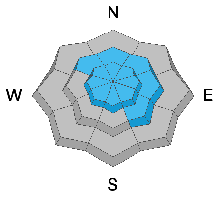
New and wind drifted snow has dangerously stressed pre-existing slabs overriding buried persistent weak layers of loose, sugary, faceted snow to their breaking point. Though any natural avalanche activity likely occurred overnight, deep and dangerous, human triggered avalanches are very likely today, especially on steep slopes facing the north half of the compass.
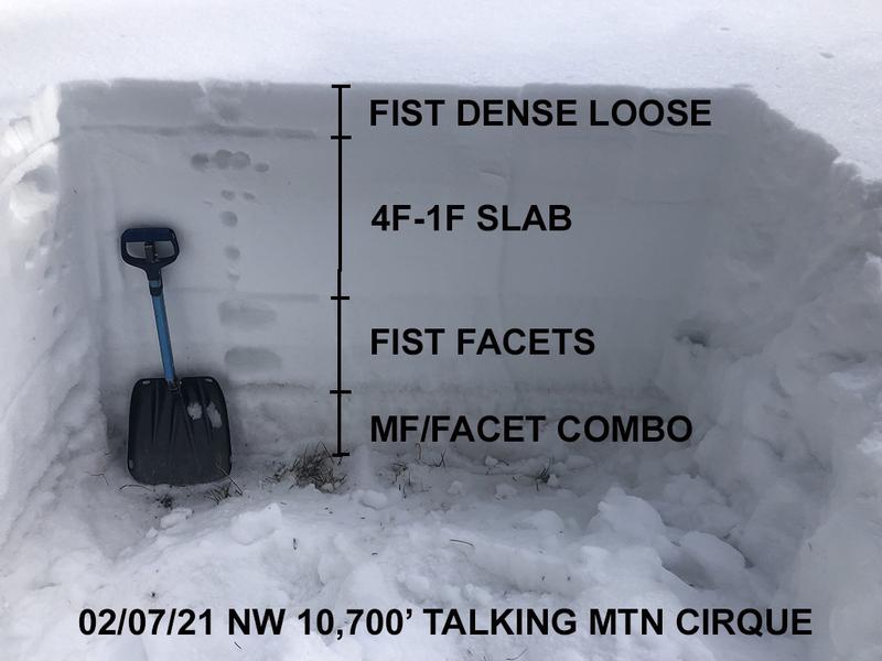
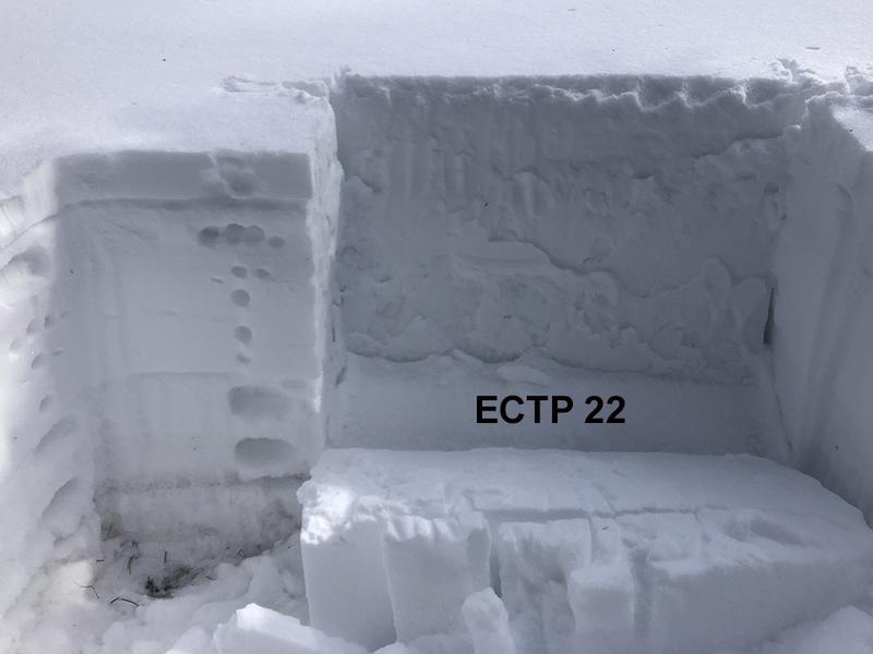
The photos below illustrates the classically poor snowpack structure that existed before this storm. Note the clearly defined fist to 4 finger hard slab on top of weak, sugary, facets. In other words - strong snow over weak snow. The additional load of new snow on top has created a dangerous, unstable situation.
Avalanche Problem #2
Wind Drifted Snow
Type
Location
Likelihood
Size
Description
Wind drifted snow has exacerbated an already dangerous situation. Fresh, unstable drifts 15"-20" deep will be very susceptible to human triggers today. They have also added additional stress to buried persistent weak layers, and once triggered they will likely produce deeper and even more dangerous avalanches. Though steep, wind drifted slopes should definitley be avoided, overall travel advice remains the same. Avoid avalanche terrain today.
Avalanche Problem #3
New Snow
Type
Location
Likelihood
Size
Description
Human triggered avalanches within the new snow will be likely on steep slopes on all aspects today. These may occur in the form of loose snow sluffs or cohesive soft slabs. On slopes facing the north half of the compass, storm snow has increased the likelihood of triggering a deeper and more dangerous avalanche. Travel advice remains the same, avoid avalanche terrain or slopes steeper than 30 degrees.
General Announcements
This forecast is from the U.S. Forest Service, which is solely responsible for its content. This forecast describes general avalanche conditions and local variations always occur.