UDOT PLANNED AVALANCHE CLOSURES!!

Forecast for the Moab Area Mountains

Eric Trenbeath
Issued by Eric Trenbeath for
Thursday, February 14, 2019
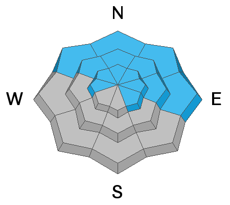
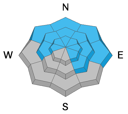
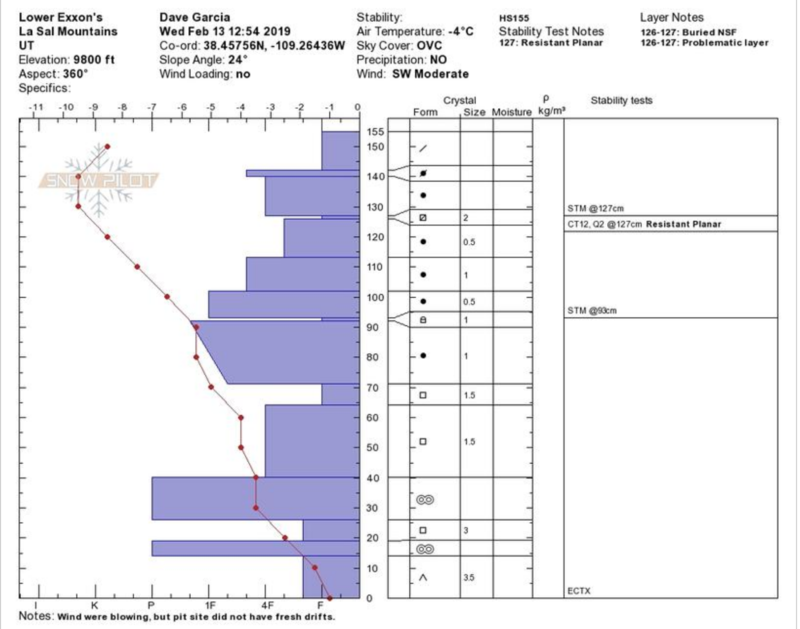
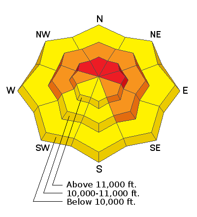
The avalanche danger is CONSIDERABLE today. Human triggered avalanches involving new and wind drifted snow are likely, and natural avalanches are possible. The danger will increase with the next wave of snow and will likely reach HIGH by sometime this evening. The danger is greatest on slopes that face NW-N-E and human triggered avalanches involving buried, persistent weak layers, are also possible in these areas. Backcountry travelers need to have excellent route finding and snow stability analysis skills. Stay off of, and out from under steep, avalanche prone terrain.
Low
Moderate
Considerable
High
Extreme
Learn how to read the forecast here
Avalanche Watch
THE FOREST SERVICE UTAH AVALANCHE CENTER IN MOAB HAS ISSUED A BACKCOUNTRY AVALANCHE WATCH.
* TIMING…IN EFFECT FROM 6 AM MST THIS MORNING TO 6 AM MST FRIDAY
* AFFECTED AREA…FOR THE LA SAL AND ABAJO MOUNTAINS OF SOUTHEASTERN UTAH
* AVALANCHE DANGER…THE AVALANCHE DANGER FOR THE WATCH AREA IS EXPECTED TO RISE TO HIGH.
* IMPACTS…STRONG WINDS WITH PERIODS OF HEAVY SNOW WILL CREATE WIDESPREAD AREAS OF UNSTABLE SNOW. THE AVALANCHE DANGER WILL REMAIN ELEVATED THROUGH THE WEEKEND WITH BOTH HUMAN TRIGGERED AND NATURAL AVALANCHES BECOMING LIKELY. TRAVEL IN AVALANCHE TERRAIN IS NOT RECOMMENDED. STAY OFF OF AND OUT FROM UNDER SLOPES STEEPER THAN 30 DEGREES.
Special Announcements
I'm sorry to report more sad news from the backcountry. On Saturday, a 49 year old man was killed in an avalanche accident on the west side of Humpy Peak in the East Fork of the Chalk Creek drainage while riding with his son and a friend. That makes four avalanche fatalities in Utah this month. A preliminary investigation is found here.
Or deepest sympathies go out to the families and friends of the victims.
Weather and Snow
A fast moving wave put down 6" of new snow between 5:00 and 8:00 p.m. yesterday. This brings storm totals for the week up to a foot at around 1" of water weight. Overnight, southerly winds continued to blow in the 20-30 mph range. We'll see a break in the action today with the next, more powerful wave arriving sometime this afternoon. Another 6"-12" is possible from this system. Today look for cloudy skies, and scattered snow showers before the main event later today. WSW winds will calm down a bit averaging 15-20 mph along ridge tops with gusts into the 30's. High temps will be near freezing. We'll see a break in the action on Friday before the next system slides through in Friday night. This storm looks like it will favor points north but we should still see a few inches.
Dave Garcia braved the windy conditions yesterday and sent in this observation, with a great clip of strong winds and blowing snow, as well as his usual careful analysis of the snowpack. He also reported lots of scoured and wind damaged surfaces in spite of Monday's 6" of snow. The additional snow from yesterday evening should help improve things, but it sounds like wind sheltered terrain is still where you want to be.
New snow totals in Gold Basin (10,000')
Snow totals at the Geyser Pass Trailhead (9600')
Wind, temperature, and humidity on Pre Laurel Peak (11,700')
National Weather Service point forecast.
Ad
Avalanche Problem #1
Wind Drifted Snow
Type
Location
Likelihood
Size
Description
Wind drifted snow continues to be our primary concern. Strong southerly winds have blown for more than a week drifting snow on to slopes facing W-N-SE, and we now have new wind slabs on top of old. Most of the older slabs have gained strength, but fresh drifts will continue to form in the most recent snow. Be alert to recent deposits of wind drifted snow on the lee sides of ridge crests and terrain features. Due to the intense winds, cross-loading will also be a factor so beware of the sides of gully walls and down slope sub ridges. Fresh drifts are often recognizable by their smooth, rounded appearance, and they may sound, and feel hollow underneath. Cracking in the snow surface is a sign of instability.
Avalanche Problem #2
Persistent Weak Layer
Type
Location
Likelihood
Size
Description
The added snow load over the next few days will be a good test for buried persistent weak layers in the snowpack. Our primary layer of concern continues to be the early December snow that has turned into weak, sugary facets on top of the October crust. Where the snowpack is deepest, this layer is mostly non-reactive. Where the pack is shallow and weak, alarming results occasionally pop up. This puts us squarely in the MODERATE category where deep and dangerous, human triggered avalanches are still possible. And as our old buddy Clint would say, "Do you feel lucky?" In addition, Dave Garcia has noted some weak layers that have formed in the upper portion of the snowpack. For the time being, I'm going to continue to avoid steep, northerly facing terrain while waiting to see how it holds up to this storm cycle.
Dave Garcia's pit profile. Primary layer of concern continues to be the December facets at 70 cms, but buried near surface facet layers exist in the upper portion of the pack.
Avalanche Problem #3
New Snow
Type
Location
Likelihood
Size
Description
As dense, wind driven snow begins to pile up, we may see avalanches within the new snow. These can occur as both loose snow sluffs, and soft, cohesive slabs. Look for cracking in the most recent snow, as well as the presence of an overriding dense slab as clues to potential instability. Long running natural avalanches within the new snow will be possible off the higher peaks and steep faces, stay out from under this type of terrain.
General Announcements
Your information can save lives. If you see anything we should know about, please help us out by submitting snow and avalanche observations HERE. You can also call me at 801-647-8896, or send me an email: [email protected].
Support the UAC through your daily shopping. When you shop at Smith's, or online at REI, Backcountry.com, Patagonia, NRS, Amazon, eBay by clicking on these links, they donate a portion of your purchase to the UAC. If you sell on eBay, you can have your See our Affiliate Page for more details on how you can support the UAC when you shop
This advisory is from the U.S.D.A. Forest Service, which is solely responsible for its content. This advisory describes general avalanche conditions and local variations always occur.