Forecast for the Moab Area Mountains

Eric Trenbeath
Issued by Eric Trenbeath for
Monday, February 11, 2019
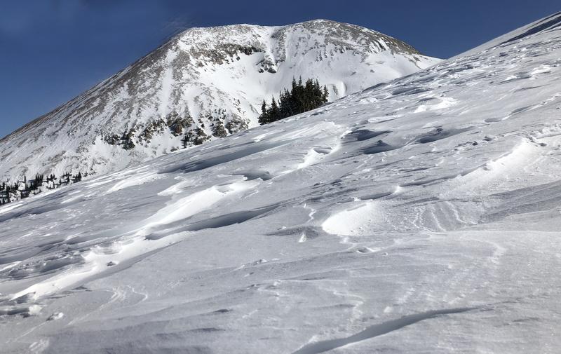
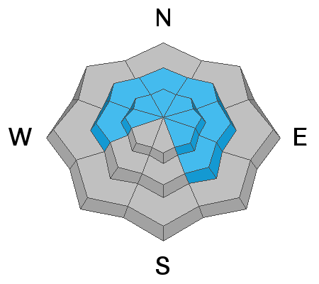
Blowing and drifting snow continue to create dangerous avalanche conditions, and the avalanche danger remains CONSIDERABLE on all steep, wind drifted slopes. The danger is greatetest on slopes that face NW-N-SE and human triggered avalanches involving wind drifted snow, and buried, persistent weak layers, are likely in these areas. Natural sluffing and wind slab releases will be possible off of the higher steep faces that have a northeasterly component to their aspect. Stay out from under this type of terrain. Most south facing terrain at mid and lower elevations has MODERATE danger.
Low
Moderate
Considerable
High
Extreme
Learn how to read the forecast here
Special Announcements
The road is plowed.
I'm sorry to report more sad news from the backcountry. On Saturday, a 49 year old man was killed in an avalanche accident on the west side of Humpy Peak in the East Fork of the Chalk Creek drainage while riding with his son and a friend. That makes four avalanche fatalities this month. A preliminary investigation is found here.
Or deepest sympathies go out to the families and friends of the victims.
Weather and Snow
A fast moving storm system is upon us. Starting just before 5:00 a.m. precipitation rates have been hammering at about 2" an hour and it looks like about 6" so far at the Geyser Pass Trailhead. The Gold Basin sensor has been unable to keep up. The storm will quickly exit the area but we may see a couple more inches. Current Pre-Laurel wind data is also unavailable but 700 mb charts (10,000') show a shift to the west with speeds in the 30 mph range. Today look for mostly cloudy skies, blustery NW winds averaging 20-25 mph, with high temps in the upper teens. Skies should begin to clear later today with dry conditions through tomorrow. A significant storm system on an "atmospheric river" looks to be headed our way on Thursday, with more snow through the weekend.
Strong southerly winds throughout the week have wreaked havoc on the snow surface, and in the words of local skier Thatcher Vagts, "It's quite remarkable how bad conditions can be with so much new snow last week." The new snow will help freshen things up quite a bit, but winds continue to blow, scour, and drift, so sheltered locations will be your best option for finding soft snow.
Base depth in Gold Basin: 60"
New snow totals in Gold Basin (10,000')
Snow totals at the Geyser Pass Trailhead (9600')
Wind, temperature, and humidity on Pre Laurel Peak (11,700')
National Weather Service point forecast.
Great conditions for learning about avalanches at our Backcountry 101 class this weekend. Thanks to all who attended!
Ad
Avalanche Problem #1
Wind Drifted Snow
Type
Location
Likelihood
Size
Description
Blowing and drifitng snow continues to be the primary concern. Sensitive new drifts will form today, and strong southerly winds throuhgout the week have drifted snow on to slopes facing NW-N-SE. Human triggered avalanches are likely on steep, wind drifted slopes in these areas. Natural avalanches are also possible. Be alert to recent deposits of wind drifted snow on the lee sides of upper elevation ridge crests and terrain features. They are often recognizable by their smooth, rounded appearance, and they may sound, and feel hollow underneath. Cracking in the snow surface is a sign of instability.
Avalanche Problem #2
Persistent Weak Layer
Type
Location
Likelihood
Size
Description
Snow stability test are starting to show varying degrees of reactivity with regard to buried, persistent weak layers. Where the snowpack is deepest, these layers are showing signs of healing, and Travis Naumnan was unable to produce any results yesterday, even with what he described as a "gorilla slap" to the column. On the other hand, I found the snow to be very reactive earlier in the week. Our primary layer of concern is the early December snow that has turned into weak, sugary facets on top of the October crust. With 21" of new snow, and almost 2" of water weight since then, I'm going to assume this layer is guilty until proven innocent. This means assuming that deep and dangerous, human triggered avalanches are possible, primarily on steep slopes at mid and upper elevations that face NW-N-E. The only way to know for sure will be to perform your own stability test on a slope by slope basis.
General Announcements
Your information can save lives. If you see anything we should know about, please help us out by submitting snow and avalanche observations HERE. You can also call me at 801-647-8896, or send me an email: [email protected].
Support the UAC through your daily shopping. When you shop at Smith's, or online at REI, Backcountry.com, Patagonia, NRS, Amazon, eBay by clicking on these links, they donate a portion of your purchase to the UAC. If you sell on eBay, you can have your See our Affiliate Page for more details on how you can support the UAC when you shop
This advisory is from the U.S.D.A. Forest Service, which is solely responsible for its content. This advisory describes general avalanche conditions and local variations always occur.