Join us at our 2nd Annual Blizzard Ball

Forecast for the Moab Area Mountains

Eric Trenbeath
Issued by Eric Trenbeath on
Saturday morning, December 31, 2022
Dangerous conditions exist and the avalanche danger will be on the rise through Monday!
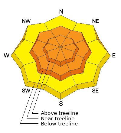
The avalanche danger remains CONSIDERABLE and human triggered avalanches are likely on all aspects near and above treeline. Dense, heavy, and wind drifted snow has overloaded buried persistent weak layers creating dangerous conditions in the backcountry. On northerly aspects, deep and dangerous, human triggered avalanches up to 4' deep are likely. Below treeline, a MODERATE danger exists and human triggered avalanches are possible.
Low
Moderate
Considerable
High
Extreme
Learn how to read the forecast here
Special Announcements
Road Conditions: Grand County plowed on Thursday but it's still kind of sporty and soft near the top. 4x4 with good tires recommended.
Grooming: LUNA groomed all trails yesterday. They will be covered in a few inches of fresh snow today.
Weather and Snow
24 Hour Snow 4" 72 Hour Snow 10" Season Total Snow 103" Base Depth at Gold Basin 54"
Winds on Pre Laurel Peak SW 15-20 Temp 26F
Weather
A deep plume of Pacific Moisture is streaming into the region. We don't seem to be in the direct flow but we should still see a decent amount of snow when it's all said and done by Monday. Today we'll see mostly cloudy skies, breezy SW winds, and some light snow. Breezy SW winds and a chance for a couple inches of snow will continue tonight with the main event arriving tomorrow. 6"-12" by Monday morning seems a safe bet for now.

General Conditions
The mid-week storm dumped a heavy load of dense snow on our fragile snowpack. The recent load has re-awakened buried persistent weak layers and we have problems on all aspects. Blowing and drifting snow continues to add more stress to these weak layers on northerly aspects, and deep and dangerous, human triggered avalanches up to 4' deep remain likely in those areas. Turning and riding conditions remain excellent but it's imperative that you avoid slopes steeper than 30 degrees. Nate Ament and company were out and about yesterday and they continued to observe red flag warning signs of instability. See their report here.
Dave Garcia and I were up on Thursday and had a good look around under mostly sunny skies. See the video below.

Snowpack and Weather Data
Gold Basin Storm Stake (10,000')
Gold Basin SNOTEL site (10,000')
SNOTEL site near Geyser Pass Winter Trailhead (9600')
Wind Station on Pre-Laurel Peak (11,400')
NWS forecast for the La Sal Mountains.
Recent Avalanches
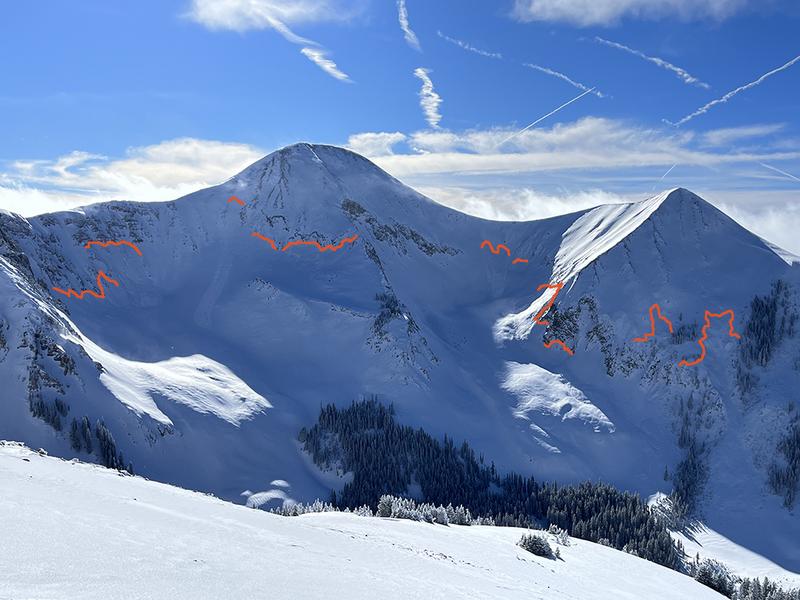
In our travels on Thursday we viewed many large avalanches on northerly aspects in Gold Basin that ran during the height of the storm cycle.
We also observed this somewhat anomalous avalanche that failed on a persistent weak layer on a SW aspect.
I'll update a complete list of avalanches in the La Sals soon.
Ad
Avalanche Problem #1
Persistent Weak Layer
Type
Location
Likelihood
Size
Description
A persistent weak layer (PWL) of faceted snow that developed during the cold dry period in mid November exists on all aspects and elevation bands in the La Sal range. Dangerous avalanche conditions exist on any slope that harbors this buried PWL including those facing south. On northerly aspects, wind drifted snow has added more stress to this buried weak layer, and human triggered avalanches up to 4' deep are likely. The snowpack is undergoing a severe test right now, and this process will continue into next week. Once this next load is applied, we'll have a better idea about the future of our snowpack. For now, all slopes steeper than 30 degrees should be avoided.
Avalanche Problem #2
Wind Drifted Snow
Type
Location
Likelihood
Size
Description
Increasing southerly winds will blow and drift snow on to leeward northerly aspects. In most cases, only shallow wind slabs will develop today. In and of themselves, they won't pose too much of a threat. The greater concern is continued accumulation on top of buried persistent weak layers. And for this reason, all steep, wind drifted slopes should be avoided.
Additional Information
General Announcements
This forecast is from the U.S.D.A. Forest Service, which is solely responsible for its content. This forecast describes general avalanche conditions and local variations always occur. This forecast will be updated by 7:30 tomorrow morning.