Forecast for the Moab Area Mountains

Eric Trenbeath
Issued by Eric Trenbeath for
Monday, December 3, 2018
The avalanche danger is HIGH today in steep, mid to upper elevation terrain that faces NW-N-E, and human triggered avalanches breaking down into buried, persistent weak layers are certain in these areas. Travel in avalanche terrain is not recommended. Avalanches can also be triggered remotely so stay clear of run out zones. Stick to low angle, or low elevation terrain and slopes that face the southern half of the compass.
Low
Moderate
Considerable
High
Extreme
Learn how to read the forecast here
Special Announcements
Grand County will be plowing routes on the mountain today and will get to Geyser Pass Trailhead later today or tomorrow. Be advised that the gate will be closed whenever they commence. For now the road is currently snow covered, rutted, and drifted with more than a foot of new snow on it though several vehicles pushed through yesterday afternoon. 4x4 and probably chains are a must, and even then it will be a challenge to reach the parking lot.
Weather and Snow
Wow, did we really get a shot! Yesterday's storm put down 19" of new snow in Gold Basin bringing totals since Friday up to 29". WSW winds averaged 25 mph along ridge tops during the first part of the storm before tapering off and shifting to the NW. Winds are currently light and it's a frigid 6 degrees at 10,000'. Today we'll see mostly sunny skies, high temps at 10,000' in the single digits, and westerly winds averaging 10-15 mph. We'll see drying conditions over the next couple of days before the next system moves in on Thursday.
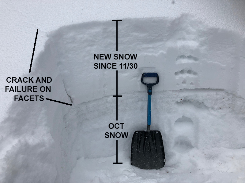
It's officially game on for winter recreation in the La Sals but it's also dangerous. Almost 30" of snow since Friday has been dumped on top of our weak, fragile base and it isn't rocket science to know that this has created an unstable situation. In addition, trail breaking today will be arduous, and low angle slopes that are safe enough to ski will be difficult to get moving on.
The following video was shot around noon yesterday, an additional 13" of snow has fallen since then.
New snow totals in Gold Basin (10,000')
Snow totals at the Geyser Pass Trailhead (9600')
Wind, temperature, and humidity on Pre Laurel Peak (11,700')
National Weather Service point forecast.
Ad
Avalanche Problem #1
Persistent Weak Layer
Type
Location
Likelihood
Size
Description
Almost 30" of snow since Friday has been added to persistent weak layers in the snowpack. These layers of weak, sugary, faceted snow are prevalent on any slope that has held snow since October. Basically any slope above about 10,000' that faces NW-N-E, and this type of terrain needs to be avoided. Human triggered avalanches up to 3' deep or more are certain in these areas. In addition, slides may be triggered remotely, and run out zones need to be given a wide berth.
This snowpit was dug around noon yesterday, an additional foot of snow now sits on top.
Avalanche Problem #2
Wind Drifted Snow
Type
Location
Likelihood
Size
Description
In my travels yesterday I observed wind drifts up to 30" deep along ridge crests along with cracking in the snow surface. Many of these drifts reach far back on to convex ridge crests. If walking along ridges, stay well back from the edge. A triggered wind slab on northerly facing aspects will most certainly step down into buried, persistent weak layers causing a much deeper avalanche. Avoid slopes with wind drifted snow.