Forecast for the Moab Area Mountains

Eric Trenbeath
Issued by Eric Trenbeath for
Tuesday, December 4, 2018
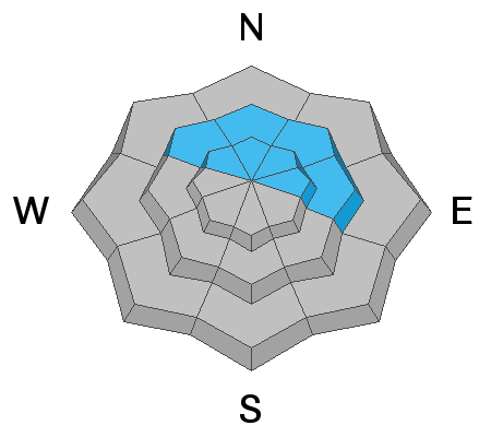
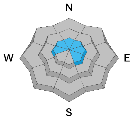
The avalanche danger is CONSIDERABLE today in steep, mid to upper elevation terrain that faces NW-N-E, and human triggered avalanches breaking down into buried, persistent weak layers are likely in these areas. Stick to low angle, or low elevation terrain and slopes that face the southern half of the compass where you'll find Moderate to Low danger.
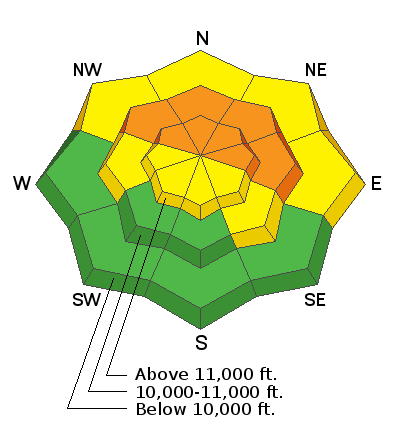
Low
Moderate
Considerable
High
Extreme
Learn how to read the forecast here
Special Announcements
Grand County plowed the road to Geyser Pass Trailhead yesterday. It is snowpacked and all wheel drive is advised.
Weather and Snow
Skies are clear, WNW winds are light, and it's a frigid 1 degree at the Geyser Pass Trailhead. 10,000' temps will rise into the mid teens today, but wind chill values will keep things well below 0. Clouds will move in tonight as a weak system clips by to the north. Wednesday will be partly cloudy and warmer with temps climbing into the low to mid 20's. Our next chance for snow comes on Thursday when a Pacific storm system will track mainly across northern Arizona and New Mexico.
It's officially game on for winter recreation in the La Sals but it's also dangerous. Almost 30" of snow since Friday has been dumped on top of our weak, fragile base and it isn't rocket science to know that this has created an unstable situation.
The following video was shot around noon on Sunday, an additional 13" of snow fell through the remainder of the day.
New snow totals in Gold Basin (10,000')
Snow totals at the Geyser Pass Trailhead (9600')
Wind, temperature, and humidity on Pre Laurel Peak (11,700')
National Weather Service point forecast.
Ad
Avalanche Problem #1
Persistent Weak Layer
Type
Location
Likelihood
Size
Description
Almost 30" of snow since Friday has been added to persistent weak layers in the snowpack. These layers of weak, sugary, faceted snow are prevalent on any slope that has held snow since October. Basically any slope above about 10,000' that faces NW-N-E, and this type of terrain needs to be avoided. Human triggered avalanches up to 3' deep are likely in these areas.
This snowpit was dug around noon on Sunday, an additional foot of snow now sits on top.
Avalanche Problem #2
Wind Drifted Snow
Type
Location
Likelihood
Size
Description
In my travels on Sunday I observed wind drifts up to 30" deep along ridge crests along with cracking in the snow surface. Many of these drifts reach far back on to convex ridge crests. If walking along ridges, stay well back from the edge. A triggered wind slab on northerly facing aspects will most certainly step down into buried, persistent weak layers causing a much deeper avalanche. Avoid slopes with wind drifted snow.