Forecast for the Moab Area Mountains

Eric Trenbeath
Issued by Eric Trenbeath for
Sunday, December 2, 2018
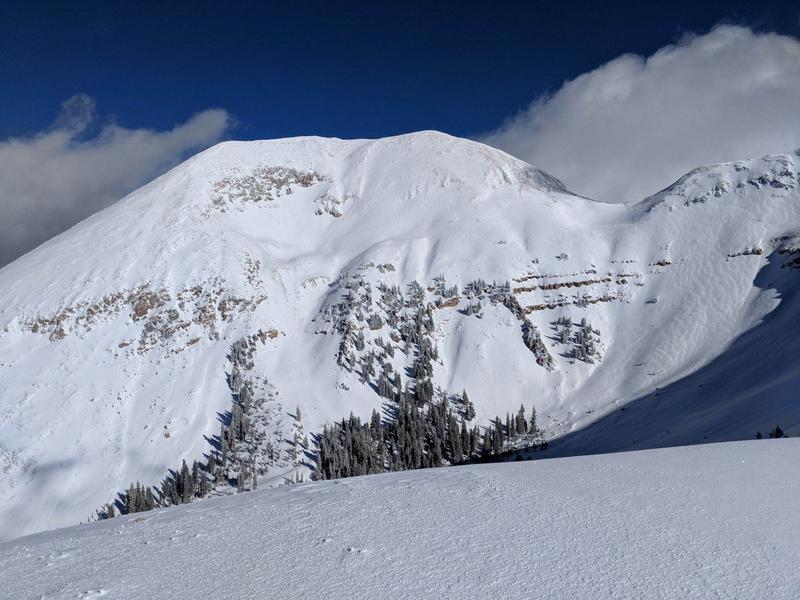
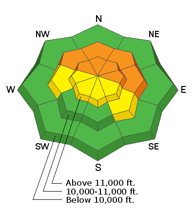
The avalanche danger is CONSIDERABLE on mid to upper elevation terrain that faces NW-N-E, and human triggered avalanches breaking down into buried, persistent weak layers are likely in these areas. Pay special attention to slopes with areas of wind drifted snow. Look for signs of instability such as cracking in the snow surface and avoid terrain that has a smooth, rounded, pillowy appearance. Below about 10,000' the avalanche danger is generally LOW.
Low
Moderate
Considerable
High
Extreme
Learn how to read the forecast here
Weather and Snow
If you look outside you'll see what you need to know! Snow began to fall in the mountains about 6:00 a.m. and southerly winds are on the increase averaging 15-20 mph range along ridge tops. 10,000' foot temps are in the mid teens, and in the single digits on Pre-Laurel Peak. We should see 4-6" of new snow today with some lingering flurries this evening. Ridge top winds will continue to blow in the 15-20 mph range shifting to westerly and finally NW as the storm exits the area. Daytime highs will be in the mid teens at 10,000'. Dry conditions move in for the first part of the week with the next storm developing Wed-Thu.
Reports from the backcountry yesterday indicated good skiing on low angle terrain with up to a foot of fluffy powder around 11,000'. Prior to this weekend's storm event, 18-24" was on the ground on northerly aspects above about 10,000'. Due south facing slopes were still bare ground. If you do venture out, be advised that low snow conditions are in effect and that many obstacles such as rocks and deadfall lay just below the surface.
New snow totals in Gold Basin (10,000')
Snow totals at the Geyser Pass Trailhead (9600')
Wind, temperature, and humidity on Pre Laurel Peak (11,700')
National Weather Service point forecast.
Looks like winter up there! Photo courtesy of Ed Grote.
Ad
Avalanche Problem #1
Persistent Weak Layer
Type
Location
Likelihood
Size
Description
The recent snowfall has begun to apply pressure on persistent weak layers in our snowpack and all it will take is the additional weight of a skier or rider to trigger an avalanche. Yesterday I received reports of collapsing, and in the words of local observer Travis Nauman, "there is a lot going on under there." On northerly aspects above 10,000' 18-24" of snow has been sitting on the ground since mid-October. This snow has been been deteriorating into weak, sugary, faceted snow near the ground, and at different levels in the snowpack. For now, the strategy is to avoid steep slopes above about 10,000' that face NW-N-E. Human triggered avalanches up to 2' deep or more are likely in these areas.
Avalanche Problem #2
Wind Drifted Snow
Type
Location
Likelihood
Size
Description
With plenty of snow available for transport, moderate winds today will drift snow and create new wind slabs in upper elevation, wind exposed terrain. Look for fresh drifts on the leeward sides of ridge crests and terrain features, and avoid steep slopes that have recent deposits of wind drifted snow. Be alert to signs of instability such as collapsing or cracking in the snow surface.
General Announcements
We are very proud to introduce our new website for the 2018-19 winter season. This will provide an easier and cleaner way to view all of the snow and avalanche information that you've come to rely on. We are quite happy with how the new website performs on mobile devices as well. We think you'll find the desktop or laptop experience pleasant as well. We are still tying up some loose ends so bear with us.