Forecast for the Moab Area Mountains

Dave Garcia
Issued by Dave Garcia for
Friday, December 29, 2023
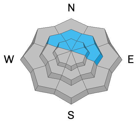
Today there is a MODERATE danger of triggering an avalanche involving persistent weak layers of faceted snow. Human-triggered avalanches are POSSIBLE on slopes near treeline and above that face NW-N-NE-E. The danger will be most pronounced on slopes that have been previously loaded by blowing and drifting snow.

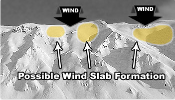
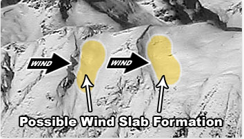
Strong Northerly winds overnight have created sensitive soft slabs of wind-drifted snow on all aspects above treeline. Avoid any steep slopes that have been recently wind-loaded.
The snowpack is still very shallow and rocks, logs, and stumps are a very real hazard right now.
Low
Moderate
Considerable
High
Extreme
Learn how to read the forecast here
Special Announcements
To fulfill our mission, the UAC relies on our amazing backcountry community. Your support helps pay for the daily avalanche forecast, free awareness presentations across the state, and new tools like the new Avalanche and Observation Explorer. As the end of the year approaches, please consider donating to the UAC.
Road Conditions: The road is plowed but the surface remains soft. AWD with good tires are required.
Grooming: Trails have not been groomed since Sunday.
Weather and Snow
6:00 a.m. Snow and Weather Data
24 Hour Snow 0" 72 Hour Snow 0" Season Total Snow 42" Base Depth at Gold Basin 24"
Winds on Pre-Laurel Peak: N 7 G 11 Temp 17˚ F

Weather
Another warm sunny day is on tap for the mountains. High temperatures will reach 30 degrees. Strong overnight winds have died down and will blow 5-10 mph out of the Northwest today. High pressure and sunshine dominate through the weekend and into early next week. Our next chance for precipitation will come around January 4th.

General Conditions
The 8 inches of snow that fell on Saturday has slightly improved conditions, but unfortunately, there is still not enough coverage for serious skiing and riding. The snowpack is weak and faceting, and not supportive enough to keep you on top of the rocks. Strong winds overnight gusted into the upper 30's adding insult to injury. The high peaks were already scoured from the weekend's strong winds. In the alpine, you will find a mix of scoured slopes alternating with a variety of wind-sculpted snow, old hard wind crusts and slabs, and shallow, sensitive, soft slabs of recently wind-drifted snow. On Wednesday I was up with Nate and Chloe and we bailed on our bigger objective because of rocks. We found the best option to be grassy slopes in low-angle meadows. See our report here. Other options include nordic skiing on the groomed summer roads. There is enough snow on the ground to bury some beacons and practice your rescue skills. Backcountry skiing is generally a game of patience, but at least we have options for enjoying winter in the mountains right now.
Snowpack and Weather Data
Gold Basin Storm Stake (10,000')
Gold Basin SNOTEL site (10,000')
SNOTEL site near Geyser Pass Winter Trailhead (9600')
Wind Station on Pre-Laurel Peak (11,400')
NWS forecast for the La Sal Mountains.
Recent Avalanches
On our tour up Horse Creek on Wednesday, we observed this small natural avalanche involving wind-drifted snow. This slide most likely occurred on Sunday or Monday during the peak of the strong winds. This is a NE aspect around 11,200 ft. This D1 avalanche is enough to knock you off your feet, rake you through some rocks, or push you off a cliff.
Ad
Avalanche Problem #1
Persistent Weak Layer
Type
Location
Likelihood
Size
Description
Overall the snow pack is very shallow, with an average depth of about two feet. The slopes that hold the most snow are where we are looking to ski right now. These are the same slopes where you can find avalanche danger involving persistent weak layers of faceted snow. The cold, shady slopes on the North side of the compass have very weak snow throughout the pack. The good news is a lot of slopes lack a proper slab right now. Be sure to read my recent obs for the nuts and bolts of it all.
To get avalanches we need strong snow over weak snow, or a cohesive slab on top of a weak layer. Slopes that might have a slab in place are the slopes that were previously loaded by the strong Northerly winds that blew Sunday and Monday. It will be possible for a skier or rider to trigger an avalanche breaking down deep into old, weak snow on these previously loaded slopes. I would be suspicious of any slope in the alpine that looks fat and filled in. Dig down and feel for strong snow on top of the weak sugary facets. If the snow feels supportive beneath your feet, chances are good that you have found a slab.
Avalanche Problem #2
Wind Drifted Snow
Type
Location
Likelihood
Size
Description
Overnight strong winds out of the Northeast gusted into the upper 30's. Northerly winds create some atypical loading patterns in the La Sals, and today it will be possible to trigger small avalanches in fresh soft slabs of wind-drifted snow on all aspects above treeline. These avalanches will be shallow and pockety in nature, but could pack enough punch to knock you off your feet. On slopes that face NW-N-NE-E, any triggered wind slab has the potential to step down to the more deeply buried facets, causing a larger and more dangerous avalanche.
The top photo shows a classic top-loading pattern and the bottom photo shows a cross-loading pattern. Northerly wind events in the La Sals will often cross load slopes and today it is possible to find sensitive soft slabs on any aspect. The recent avalanche in the Horse Creek Chutes is a good example of a cross-loaded slope.
General Announcements
This forecast is from the U.S.D.A. Forest Service, which is solely responsible for its content. This forecast describes general avalanche conditions and local variations always occur.