Forecast for the Moab Area Mountains

Eric Trenbeath
Issued by Eric Trenbeath for
Saturday, December 23, 2023
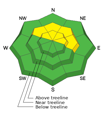
As new snow accumulates the danger will likely rise to MODERATE today on steep, upper elevation slopes that face NW-N-E. In these areas, human triggered soft slabs of new and wind drifted snow are possible. In some cases, slabs may step down into buried weak layers of sugary, faceted snow. These areas are extremely difficult to access due to low snow conditions, but if a slope looks like it has enough snow to ride, it has enough to slide. Suspect the deepest snow areas on the leeward sides of ridge crests and terrain features. Even a small avalanche triggered could take you for a very bumpy ride.
Low
Moderate
Considerable
High
Extreme
Learn how to read the forecast here
Special Announcements
The Geyser Pass Road will be covered in a few inches of fresh snow over a snowpacked surface. AWD and good tires required.
Grooming: Expect grooming to commence after this storm.
Weather and Snow
General Conditions
We're finally getting something. The Gold Basin storm stake is reporting 3.5" as of 7:00 a.m. and it's forecasted to snow throughout the day with another 6" possible. Southerly winds overnight blew in the 20-30 mph range for several hours but are now mostly light, averaging 10 mph along ridge tops. We are riding a fine line between 1) having enough snow to finally get around on, and 2) having enough snow to create avalanche problems. The existing snowpack is very weak (see this observation from Dave Garcia) and it won't take much of a load to set it off but I don't think this is going to be quite enough. The bottom line is that you'll need to be alert to changing conditions today. If we see more than about 6" of new snow we may start to see some problems, primarily on upper elevation, northerly aspects where human triggered soft slabs of recent, and wind drifted snow may pack enough of a punch to step down into weaker, faceted snow beneath.
Your greatest danger right now will come from sliding around in low-tide conditions. Rocks, stumps and deadfall are lurking everywhere, and the new snow will just barely cover them. Stick to roads and known grassy meadows and slopes.
Check out this video of Dave Garcia describing the underlying snowpack:
Snowpack and Weather Data
Gold Basin Storm Stake (10,000')
Gold Basin SNOTEL site (10,000')
SNOTEL site near Geyser Pass Winter Trailhead (9600')
Wind Station on Pre-Laurel Peak (11,400')
NWS forecast for the La Sal Mountains.
Recent Avalanches
No recent avalanches have been reported.
Ad
Avalanche Problem #1
New Snow
Type
Location
Likelihood
Size
Description
Areas of new and wind drifted snow may become problematic today if totals exceede more than 6". Human triggered, soft slab avalanches will be possible on steep, upper elevation, northerly aspects. In some cases, a triggered new snow avalanche may step down into weaker, buried facets. Any avalanche triggered, even a small one, could result in a very rough and bumpy ride.
Additional Information
Several inches of pre-existing snow has turned to weak, sugary facets at the base of the snowpack on northerly aspects. Time will tell how big of a problem this becomes, but we'll be keeping an eye on it. For now, it's only a concern in upper elevation, northerly facing terrain where winds have drifted slabs over top. Most of the areas where you would encounter a problem are difficult to access because of the low coverage, but if you find yourself in the upper elevations, remember that if it has enough snow to ride, it has enough snow to slide. Suspect the deepest snow areas on the leeward sides of ridge crests and terrain features. Even a small avalanche triggered could take you for a very bumpy ride.
The snowpit below illustrates the weak, fragile nature of the underlying snowpack. This will undoubtedly become a persistent weak layer problem as snow accumulates on top.
General Announcements
This forecast is from the U.S.D.A. Forest Service, which is solely responsible for its content. This forecast describes general avalanche conditions and local variations always occur.